Milstead Topo Map Georgia
To zoom in, hover over the map of Milstead
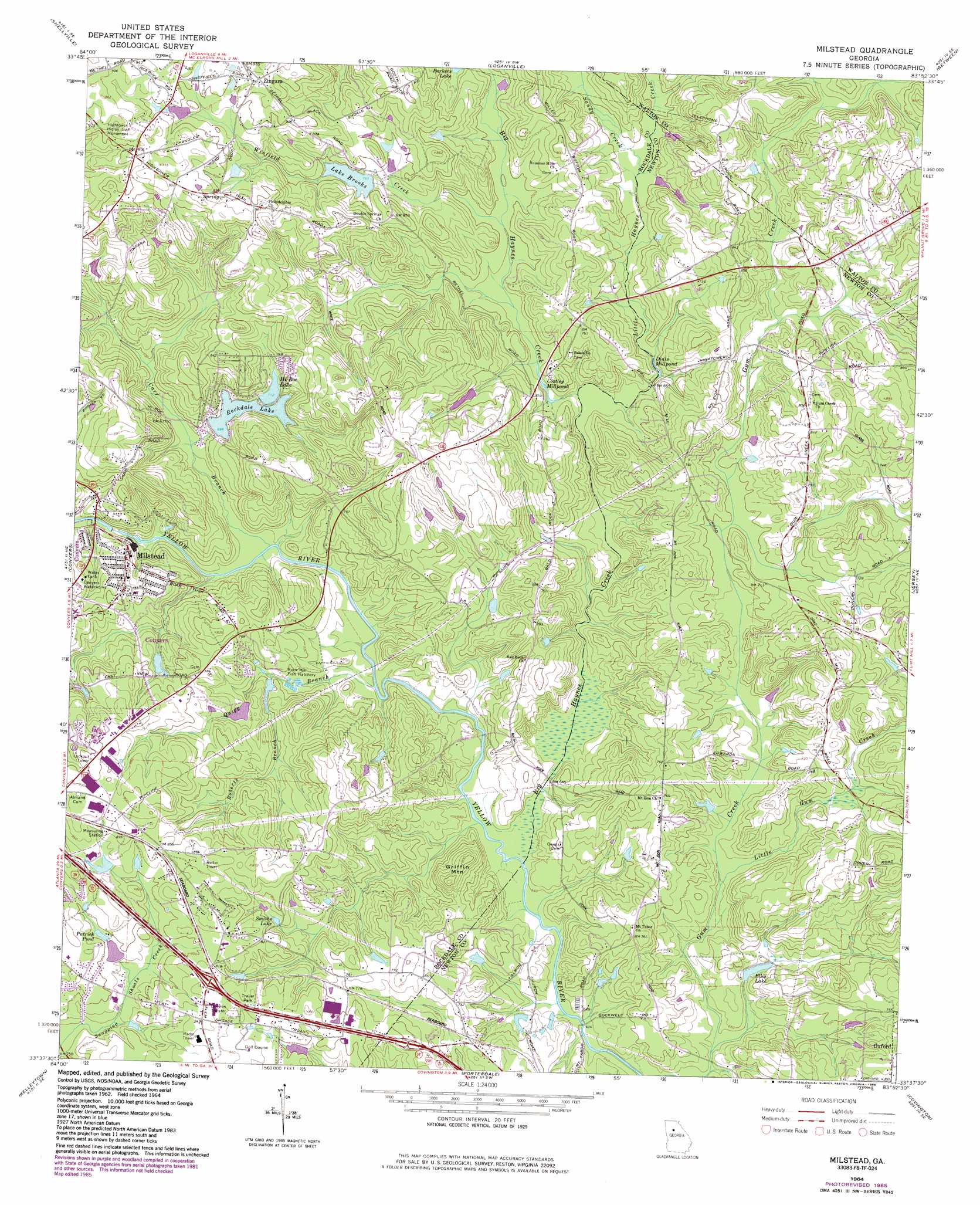
USGS Topo Quad 33083f8 - 1:24,000 scale
| Topo Map Name: | Milstead |
| USGS Topo Quad ID: | 33083f8 |
| Print Size: | ca. 21 1/4" wide x 27" high |
| Southeast Coordinates: | 33.625° N latitude / 83.875° W longitude |
| Map Center Coordinates: | 33.6875° N latitude / 83.9375° W longitude |
| U.S. State: | GA |
| Filename: | o33083f8.jpg |
| Download Map JPG Image: | Milstead topo map 1:24,000 scale |
| Map Type: | Topographic |
| Topo Series: | 7.5´ |
| Map Scale: | 1:24,000 |
| Source of Map Images: | United States Geological Survey (USGS) |
| Alternate Map Versions: |
Milstead GA 1964, updated 1966 Download PDF Buy paper map Milstead GA 1964, updated 1976 Download PDF Buy paper map Milstead GA 1964, updated 1985 Download PDF Buy paper map Milstead GA 1993, updated 2000 Download PDF Buy paper map Milstead GA 1999, updated 2002 Download PDF Buy paper map Milstead GA 2011 Download PDF Buy paper map Milstead GA 2014 Download PDF Buy paper map |
1:24,000 Topo Quads surrounding Milstead
Norcross |
Luxomni |
Lawrenceville |
Bold Springs |
Winder South |
Stone Mountain |
Snellville |
Loganville |
Between |
Monroe |
Redan |
Conyers |
Milstead |
Jersey |
Social Circle |
Stockbridge |
Kelleytown |
Porterdale |
Covington |
Mansfield |
Mcdonough |
Ola |
Worthville |
Stewart |
Farrar |
> Back to 33083e1 at 1:100,000 scale
> Back to 33082a1 at 1:250,000 scale
> Back to U.S. Topo Maps home
Milstead topo map: Gazetteer
Milstead: Airports
Lola Landing Airport elevation 277m 908′Milstead: Areas
The Rocks elevation 266m 872′Milstead: Bridges
McDaniel Bridge elevation 194m 636′Pine Log Bridge elevation 200m 656′
Milstead: Crossings
Exit 43 elevation 255m 836′Milstead: Dams
Coursey Lake Dam elevation 255m 836′Cousins Lake Dam elevation 231m 757′
East View Lake Dam elevation 221m 725′
Georges Lake Dam elevation 231m 757′
Hi-Roc Lake Dam elevation 217m 711′
Lake Brooks Dam elevation 234m 767′
Rockdale Lake Dam elevation 215m 705′
Sheppards Lake Dam elevation 244m 800′
Weaver Lake Dam elevation 230m 754′
Milstead: Lakes
Costley Millpond elevation 208m 682′Dials Millpond elevation 202m 662′
Milstead: Parks
Big Haynes Creek Recreation Area elevation 213m 698′Georgia International Horse Park elevation 227m 744′
Hightower Indian Trail Monument elevation 272m 892′
Pine Log Park elevation 271m 889′
Milstead: Populated Places
Ashley Grove elevation 248m 813′Cambridge Forest elevation 239m 784′
Hi Roc Shores elevation 253m 830′
Hightower Forest elevation 220m 721′
Horseshoe Springs elevation 232m 761′
Milstead elevation 237m 777′
North Conyers Farms elevation 239m 784′
Princeton (historical) elevation 238m 780′
Spring Valley elevation 255m 836′
Twin Haynes Creek elevation 207m 679′
Zingara elevation 284m 931′
Milstead: Reservoirs
Coursey Lake elevation 255m 836′Cousins Lake elevation 231m 757′
East View Lake elevation 221m 725′
Ellis Lake elevation 199m 652′
Georges Lake elevation 231m 757′
Hi-Roc Lake elevation 217m 711′
Lake Brooks elevation 234m 767′
Lake Brooks Dam elevation 231m 757′
Patrick Pond elevation 240m 787′
Rockdale elevation 252m 826′
Rockdale Lake elevation 215m 705′
Sheppards Lake elevation 244m 800′
Smiths Lake elevation 233m 764′
Weaver Lake elevation 230m 754′
Milstead: Streams
Big Haynes Creek elevation 194m 636′Boar Tusk Branch elevation 200m 656′
Carr Branch elevation 200m 656′
Little Gum Creek elevation 194m 636′
Little Haynes Creek elevation 199m 652′
Quigg Branch elevation 195m 639′
Roberts Branch elevation 207m 679′
Sandy Creek elevation 209m 685′
Winfield Creek elevation 212m 695′
Milstead: Summits
Griffin Mountain elevation 250m 820′Milstead digital topo map on disk
Buy this Milstead topo map showing relief, roads, GPS coordinates and other geographical features, as a high-resolution digital map file on DVD:
South Carolina, Western North Carolina & Northeastern Georgia
Buy digital topo maps: South Carolina, Western North Carolina & Northeastern Georgia