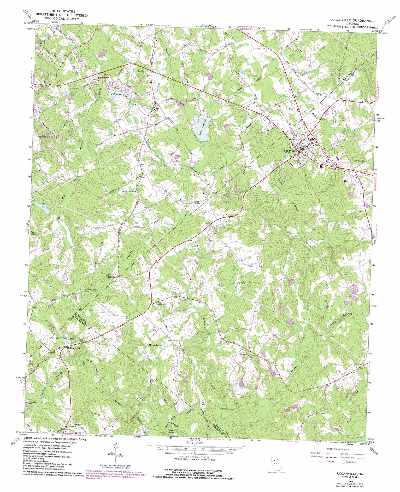
Loganville Topo Map Georgia
To zoom in, hover over the map of Loganville
USGS Topo Quad 33083g8 - 1:24,000 scale
| Topo Map Name: | Loganville |
| USGS Topo Quad ID: | 33083g8 |
| Print Size: | ca. 21 1/4" wide x 27" high |
| Southeast Coordinates: | 33.75° N latitude / 83.875° W longitude |
| Map Center Coordinates: | 33.8125° N latitude / 83.9375° W longitude |
| U.S. State: | GA |
| Filename: | o33083g8.jpg |
| Download Map JPG Image: | Loganville topo map 1:24,000 scale |
| Map Type: | Topographic |
| Topo Series: | 7.5´ |
| Map Scale: | 1:24,000 |
| Source of Map Images: | United States Geological Survey (USGS) |
| Alternate Map Versions: |
Loganville GA 1964, updated 1965 Download PDF Buy paper map Loganville GA 1964, updated 1985 Download PDF Buy paper map Loganville GA 2011 Download PDF Buy paper map Loganville GA 2014 Download PDF Buy paper map |
1:24,000 Topo Quads surrounding Loganville
Duluth |
Suwanee |
Hog Mountain |
Auburn |
Winder North |
Norcross |
Luxomni |
Lawrenceville |
Bold Springs |
Winder South |
Stone Mountain |
Snellville |
Loganville |
Between |
Monroe |
Redan |
Conyers |
Milstead |
Jersey |
Social Circle |
Stockbridge |
Kelleytown |
Porterdale |
Covington |
Mansfield |
> Back to 33083e1 at 1:100,000 scale
> Back to 33082a1 at 1:250,000 scale
> Back to U.S. Topo Maps home
Loganville topo map: Gazetteer
Loganville: Airports
Lenora Airport elevation 281m 921′Whispering Pines Airport elevation 277m 908′
Loganville: Bars
Black Shoals elevation 217m 711′Indian Shoals elevation 226m 741′
Loganville: Dams
Amatriain Lake Dam elevation 279m 915′Anderson Lake Dam elevation 232m 761′
Anderson Lake Dam III elevation 236m 774′
Bushy Haynes Creek Watershed Structure Number 21 Dam elevation 287m 941′
Carls Twin Lakes Dam elevation 262m 859′
Dew Dam 25 elevation 275m 902′
Henderson Dam elevation 239m 784′
Hickman Dam elevation 225m 738′
Johnson Lake Dam elevation 275m 902′
Lake Carlton Dam elevation 282m 925′
Tuggle Dam 22 elevation 294m 964′
Loganville: Lakes
Parkers Lake elevation 215m 705′Loganville: Parks
Rosebud Park elevation 307m 1007′Vines Botanical Gardens elevation 305m 1000′
Loganville: Populated Places
Abington Park elevation 302m 990′Compton Woods elevation 299m 980′
Falcon Ridge elevation 290m 951′
Lake Carlton elevation 291m 954′
Loganville elevation 305m 1000′
McElroys Mill elevation 271m 889′
Overlook Point elevation 286m 938′
Rose Garden elevation 305m 1000′
Rosebud elevation 274m 898′
Saddle Club Estates elevation 300m 984′
Summit Chase elevation 290m 951′
Sunny Acres elevation 314m 1030′
The Station elevation 278m 912′
Walkers Park elevation 294m 964′
Willow Wind elevation 306m 1003′
Loganville: Post Offices
Loganville Post Office elevation 306m 1003′Loganville: Reservoirs
Amatriain Lake elevation 279m 915′Anderson Lake elevation 232m 761′
Anderson Lake III elevation 236m 774′
Beaver Lake elevation 267m 875′
Brooks Lake elevation 287m 941′
Carls Twin Lakes elevation 262m 859′
Dew Lake elevation 275m 902′
Henderson Lake elevation 239m 784′
Hickman Lake elevation 225m 738′
Johnson Lake elevation 275m 902′
Lake Carlton elevation 282m 925′
Moons Lake elevation 273m 895′
Tuggle Lake elevation 294m 964′
Loganville: Streams
Brushy Fork elevation 256m 839′Little Panther Creek elevation 232m 761′
Rocky Branch elevation 230m 754′
Loganville digital topo map on disk
Buy this Loganville topo map showing relief, roads, GPS coordinates and other geographical features, as a high-resolution digital map file on DVD:
South Carolina, Western North Carolina & Northeastern Georgia
Buy digital topo maps: South Carolina, Western North Carolina & Northeastern Georgia