Winder South Topo Map Georgia
To zoom in, hover over the map of Winder South
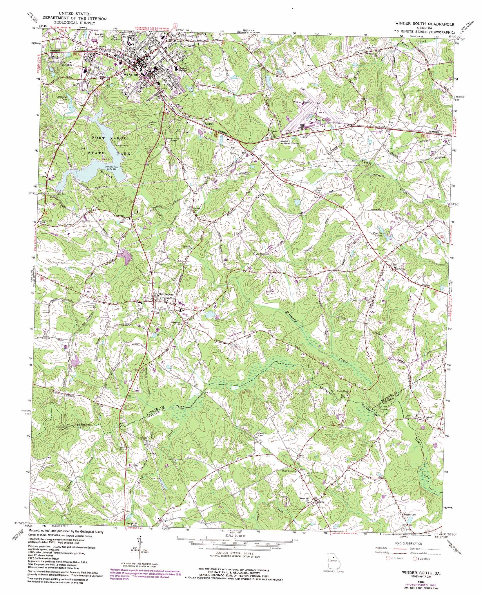
USGS Topo Quad 33083h6 - 1:24,000 scale
| Topo Map Name: | Winder South |
| USGS Topo Quad ID: | 33083h6 |
| Print Size: | ca. 21 1/4" wide x 27" high |
| Southeast Coordinates: | 33.875° N latitude / 83.625° W longitude |
| Map Center Coordinates: | 33.9375° N latitude / 83.6875° W longitude |
| U.S. State: | GA |
| Filename: | o33083h6.jpg |
| Download Map JPG Image: | Winder South topo map 1:24,000 scale |
| Map Type: | Topographic |
| Topo Series: | 7.5´ |
| Map Scale: | 1:24,000 |
| Source of Map Images: | United States Geological Survey (USGS) |
| Alternate Map Versions: |
Winder South GA 1964, updated 1965 Download PDF Buy paper map Winder South GA 2011 Download PDF Buy paper map Winder South GA 2014 Download PDF Buy paper map |
1:24,000 Topo Quads surrounding Winder South
Flowery Branch |
Chestnut Mountain |
Pendergrass |
Apple Valley |
Commerce |
Hog Mountain |
Auburn |
Winder North |
Jefferson |
Nicholson |
Lawrenceville |
Bold Springs |
Winder South |
Statham |
Athens West |
Loganville |
Between |
Monroe |
High Shoals |
Watkinsville |
Milstead |
Jersey |
Social Circle |
Rutledge North |
Apalachee |
> Back to 33083e1 at 1:100,000 scale
> Back to 33082a1 at 1:250,000 scale
> Back to U.S. Topo Maps home
Winder South topo map: Gazetteer
Winder South: Airports
Winder Airport elevation 280m 918′Winder South: Bridges
Kilgore Mill Covered Bridge elevation 232m 761′Sims Bridge elevation 219m 718′
Winder South: Dams
Harrison Dam elevation 237m 777′Lower Twin Lake Dam elevation 258m 846′
Masseys Lake Dam elevation 258m 846′
Winder South: Parks
Athens-Candler-Church Street Historic District elevation 299m 980′Broad Street Commercial Historic District elevation 301m 987′
Fort Yargo State Park elevation 260m 853′
Jackson Street Commerical Historic District elevation 301m 987′
North Broad Street Residential Historic District elevation 295m 967′
Russell Homeplace Historic District elevation 292m 958′
Winder South: Populated Places
Barrow Heights elevation 290m 951′Bethlehem elevation 263m 862′
Bradley elevation 232m 761′
Gratis elevation 250m 820′
Russell elevation 298m 977′
Winder elevation 301m 987′
Winder South: Post Offices
Winder Post Office elevation 300m 984′Winder South: Reservoirs
Harrison Lake elevation 237m 777′Lower Twin Lake elevation 258m 846′
Marburg Creek elevation 261m 856′
Masseys Lake elevation 258m 846′
Perkins Lakes elevation 261m 856′
Winder South: Streams
Camp Creek elevation 226m 741′Marbury Creek elevation 218m 715′
Rocky Creek elevation 225m 738′
Wildcat Creek elevation 231m 757′
Winder South digital topo map on disk
Buy this Winder South topo map showing relief, roads, GPS coordinates and other geographical features, as a high-resolution digital map file on DVD:
South Carolina, Western North Carolina & Northeastern Georgia
Buy digital topo maps: South Carolina, Western North Carolina & Northeastern Georgia