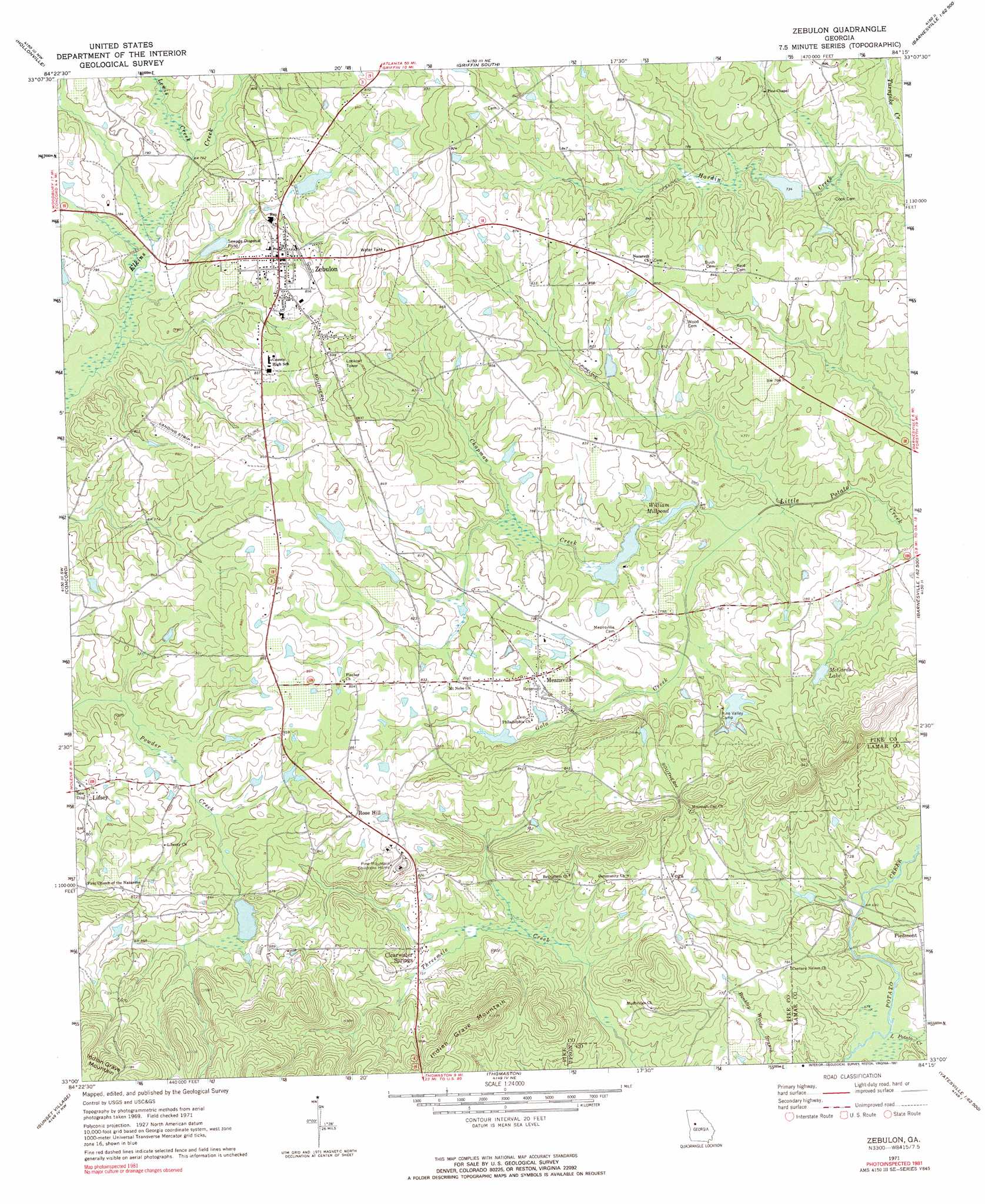
Zebulon Topo Map Georgia
To zoom in, hover over the map of Zebulon
USGS Topo Quad 33084a3 - 1:24,000 scale
| Topo Map Name: | Zebulon |
| USGS Topo Quad ID: | 33084a3 |
| Print Size: | ca. 21 1/4" wide x 27" high |
| Southeast Coordinates: | 33° N latitude / 84.25° W longitude |
| Map Center Coordinates: | 33.0625° N latitude / 84.3125° W longitude |
| U.S. State: | GA |
| Filename: | o33084a3.jpg |
| Download Map JPG Image: | Zebulon topo map 1:24,000 scale |
| Map Type: | Topographic |
| Topo Series: | 7.5´ |
| Map Scale: | 1:24,000 |
| Source of Map Images: | United States Geological Survey (USGS) |
| Alternate Map Versions: |
Zebulon GA 1971, updated 1973 Download PDF Buy paper map Zebulon GA 1971, updated 1991 Download PDF Buy paper map Zebulon GA 2011 Download PDF Buy paper map Zebulon GA 2014 Download PDF Buy paper map |
1:24,000 Topo Quads surrounding Zebulon
Senoia |
Brooks |
Griffin North |
Luella |
Locust Grove |
Haralson |
Hollonville |
Griffin South |
Orchard Hill |
High Falls |
Gay |
Concord |
Zebulon |
Barnesville |
Johnstonville |
Woodbury |
Sunset Village |
Thomaston |
Yatesville |
Strouds |
Manchester |
Roland |
Lincoln Park |
Logtown |
Culloden |
> Back to 33084a1 at 1:100,000 scale
> Back to 33084a1 at 1:250,000 scale
> Back to U.S. Topo Maps home
Zebulon topo map: Gazetteer
Zebulon: Airports
Brown Field elevation 258m 846′Hilltop Airport elevation 264m 866′
Ridgeview Farm Airport elevation 254m 833′
Zebulon: Dams
Edwards Lake Dam elevation 247m 810′Hankins Lake Dam elevation 253m 830′
Hawkins Lake Dam elevation 253m 830′
McCards Lake Dam elevation 234m 767′
Middlebrooks Lake Dam elevation 237m 777′
Pine Valley Camp Lake Dam elevation 241m 790′
Potato Creek Structure Number 33 Dam elevation 239m 784′
Potato Creek Structure Number 66 Dam elevation 236m 774′
Zebulon: Lakes
William Millpond elevation 223m 731′Zebulon: Populated Places
Clearwater Springs elevation 231m 757′Lifsey elevation 236m 774′
Meansville elevation 241m 790′
Old Newman (historical) elevation 255m 836′
Piedmont elevation 220m 721′
Rose Hill elevation 269m 882′
Vega elevation 250m 820′
Weaver (historical) elevation 263m 862′
Zebulon elevation 263m 862′
Zebulon: Reservoirs
Edwards Lake elevation 247m 810′Hankins Lake elevation 253m 830′
Harden Lake elevation 225m 738′
Hawkins Lake elevation 253m 830′
McCards Lake elevation 234m 767′
Middlebrooks Lake elevation 237m 777′
Pine Valley Camp Lake elevation 241m 790′
Potato Creek Structure Number 33 Lake elevation 239m 784′
Potato Creek Structure Number 66 Lake elevation 236m 774′
Zebulon: Streams
Chapman Creek elevation 215m 705′Gola Creek elevation 215m 705′
Lewis Creek elevation 229m 751′
Little Potato Creek elevation 205m 672′
Zebulon digital topo map on disk
Buy this Zebulon topo map showing relief, roads, GPS coordinates and other geographical features, as a high-resolution digital map file on DVD: