Concord Topo Map Georgia
To zoom in, hover over the map of Concord
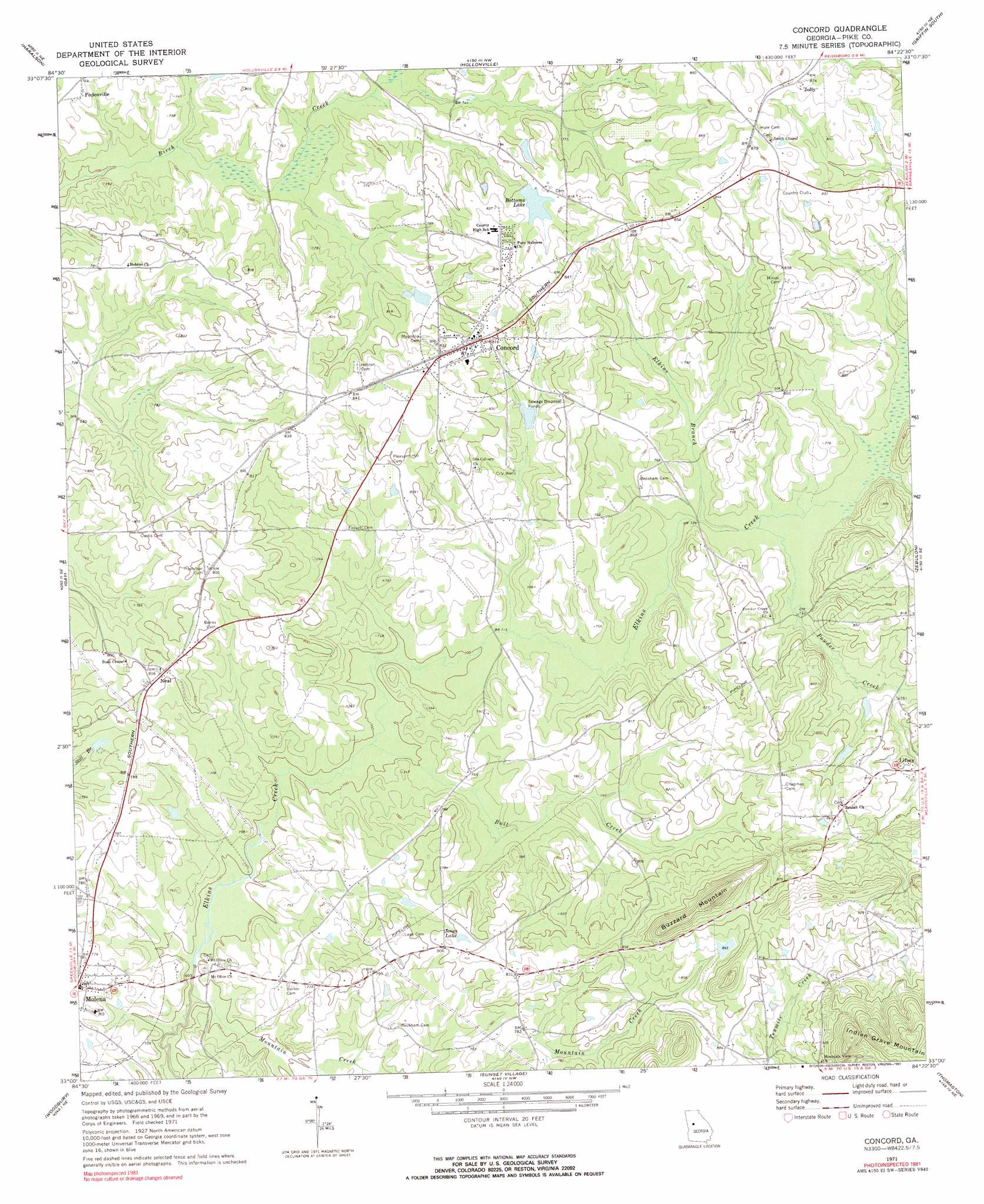
USGS Topo Quad 33084a4 - 1:24,000 scale
| Topo Map Name: | Concord |
| USGS Topo Quad ID: | 33084a4 |
| Print Size: | ca. 21 1/4" wide x 27" high |
| Southeast Coordinates: | 33° N latitude / 84.375° W longitude |
| Map Center Coordinates: | 33.0625° N latitude / 84.4375° W longitude |
| U.S. State: | GA |
| Filename: | o33084a4.jpg |
| Download Map JPG Image: | Concord topo map 1:24,000 scale |
| Map Type: | Topographic |
| Topo Series: | 7.5´ |
| Map Scale: | 1:24,000 |
| Source of Map Images: | United States Geological Survey (USGS) |
| Alternate Map Versions: |
Concord GA 1971, updated 1973 Download PDF Buy paper map Concord GA 1971, updated 1991 Download PDF Buy paper map Concord GA 2011 Download PDF Buy paper map Concord GA 2014 Download PDF Buy paper map |
1:24,000 Topo Quads surrounding Concord
Sharpsburg |
Senoia |
Brooks |
Griffin North |
Luella |
Luthersville |
Haralson |
Hollonville |
Griffin South |
Orchard Hill |
Greenville |
Gay |
Concord |
Zebulon |
Barnesville |
Warm Springs |
Woodbury |
Sunset Village |
Thomaston |
Yatesville |
Shiloh |
Manchester |
Roland |
Lincoln Park |
Logtown |
> Back to 33084a1 at 1:100,000 scale
> Back to 33084a1 at 1:250,000 scale
> Back to U.S. Topo Maps home
Concord topo map: Gazetteer
Concord: Airports
Flying 'H' Ranch Airport elevation 238m 780′Meadowlark Airport elevation 240m 787′
Takle Field elevation 243m 797′
Thacker Field elevation 258m 846′
Triple Snap Ranch Airport elevation 235m 770′
Windrift Aerodrome elevation 236m 774′
Concord: Dams
Bates Pond Dam elevation 263m 862′Bottoms Lake Dam elevation 246m 807′
Johnson Lake Dam elevation 224m 734′
Jones Lake Dam elevation 225m 738′
Upper Wildwood Farms Lake Dam elevation 232m 761′
Wildwood Farms Lake Dam elevation 224m 734′
Concord: Lakes
Jones Lake elevation 246m 807′Concord: Populated Places
Barker elevation 229m 751′Bottoms elevation 263m 862′
Concord elevation 245m 803′
Hilltop elevation 259m 849′
Jolly elevation 268m 879′
Neal elevation 247m 810′
Pedenville elevation 233m 764′
Smiths Chapel elevation 264m 866′
Concord: Reservoirs
Bates Pond elevation 263m 862′Bottoms Lake elevation 246m 807′
Johnson Lake elevation 224m 734′
Jones Lake elevation 225m 738′
Upper Wildwood Farms Lake elevation 232m 761′
Wildwood Farms Lake elevation 224m 734′
Concord: Streams
Bull Creek elevation 211m 692′Clear Creek elevation 215m 705′
Elkins Branch elevation 219m 718′
Mountain Creek elevation 204m 669′
Powder Creek elevation 220m 721′
Concord: Summits
Buzzard Mountain elevation 336m 1102′Concord digital topo map on disk
Buy this Concord topo map showing relief, roads, GPS coordinates and other geographical features, as a high-resolution digital map file on DVD: