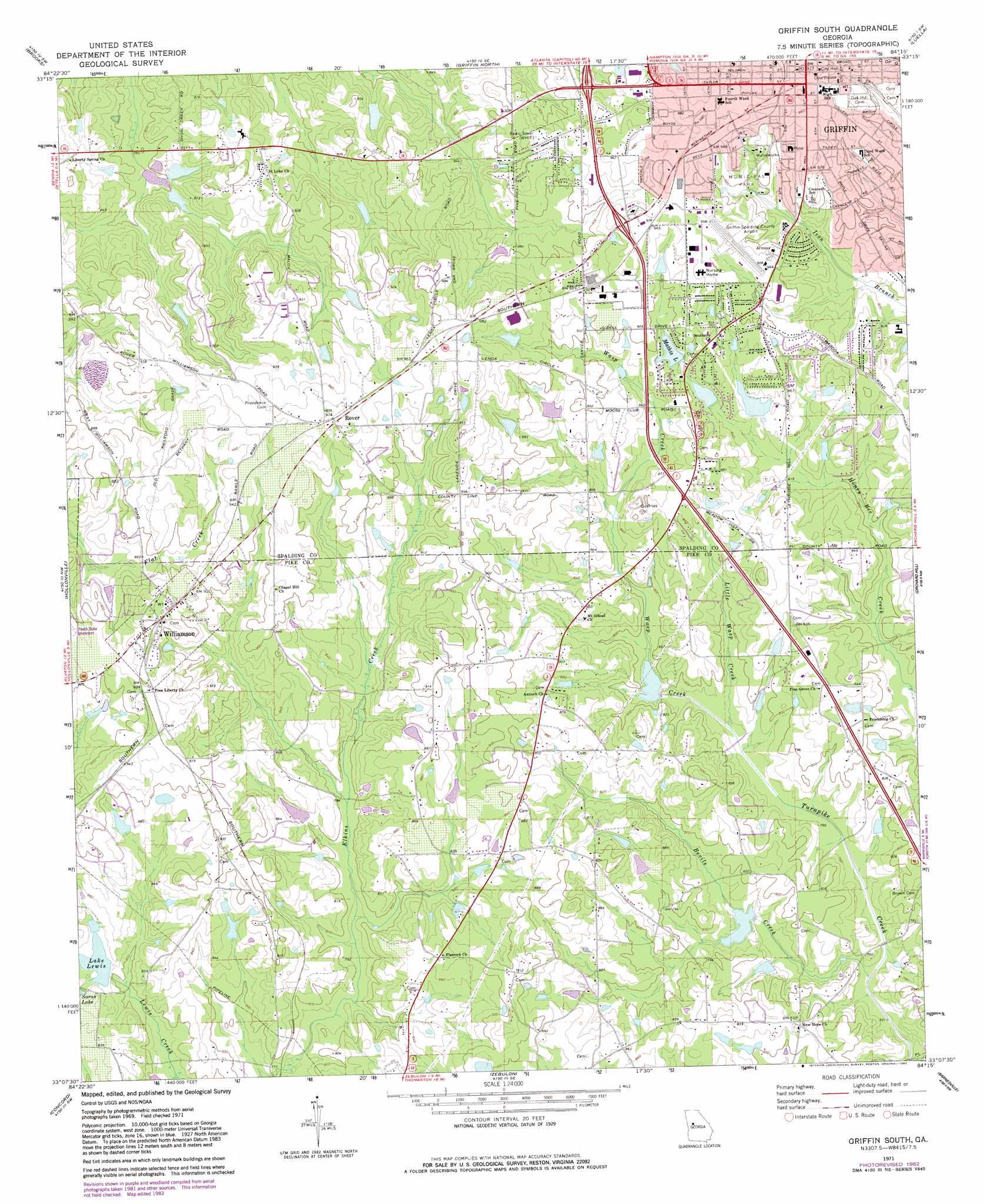
Griffin South Topo Map Georgia
To zoom in, hover over the map of Griffin South
USGS Topo Quad 33084b3 - 1:24,000 scale
| Topo Map Name: | Griffin South |
| USGS Topo Quad ID: | 33084b3 |
| Print Size: | ca. 21 1/4" wide x 27" high |
| Southeast Coordinates: | 33.125° N latitude / 84.25° W longitude |
| Map Center Coordinates: | 33.1875° N latitude / 84.3125° W longitude |
| U.S. State: | GA |
| Filename: | o33084b3.jpg |
| Download Map JPG Image: | Griffin South topo map 1:24,000 scale |
| Map Type: | Topographic |
| Topo Series: | 7.5´ |
| Map Scale: | 1:24,000 |
| Source of Map Images: | United States Geological Survey (USGS) |
| Alternate Map Versions: |
Griffin South GA 1971, updated 1973 Download PDF Buy paper map Griffin South GA 1971, updated 1983 Download PDF Buy paper map Griffin South GA 2011 Download PDF Buy paper map Griffin South GA 2014 Download PDF Buy paper map |
1:24,000 Topo Quads surrounding Griffin South
Tyrone |
Fayetteville |
Hampton |
Mcdonough |
Ola |
Senoia |
Brooks |
Griffin North |
Luella |
Locust Grove |
Haralson |
Hollonville |
Griffin South |
Orchard Hill |
High Falls |
Gay |
Concord |
Zebulon |
Barnesville |
Johnstonville |
Woodbury |
Sunset Village |
Thomaston |
Yatesville |
Strouds |
> Back to 33084a1 at 1:100,000 scale
> Back to 33084a1 at 1:250,000 scale
> Back to U.S. Topo Maps home
Griffin South topo map: Gazetteer
Griffin South: Airports
Eagles Landing Airport elevation 276m 905′Griffin-Spalding County Airport elevation 287m 941′
Kitchens Field elevation 237m 777′
Peach State Airport elevation 274m 898′
S and S Landing Strip elevation 258m 846′
Griffin South: Dams
Brown Lake Dam elevation 263m 862′Browns Pond Dam elevation 256m 839′
Corley Lake Dam elevation 257m 843′
Eagles Landing Estates Dam elevation 259m 849′
Ferrel Lake Dam elevation 272m 892′
Johnson Lake Dam elevation 259m 849′
Lake Lewis Dam elevation 250m 820′
Leach Lake Dam elevation 229m 751′
Louise Lake Dam elevation 259m 849′
Mathis Lake Dam elevation 265m 869′
Morris Lake Dam elevation 251m 823′
Potato Creek Watershed Structure 56 Dam elevation 235m 770′
Potato Creek Watershed Structure 58 Dam elevation 229m 751′
Griffin South: Lakes
Saras Lake elevation 256m 839′Griffin South: Mines
Griffin Quarry elevation 269m 882′Griffin South: Parks
Griffin Commerical Historic District elevation 298m 977′Griffin South: Populated Places
Griffin elevation 298m 977′Rover elevation 289m 948′
Williamson elevation 281m 921′
Griffin South: Post Offices
Griffin Post Office elevation 296m 971′Griffin South: Reservoirs
Bevils Creek Lake elevation 229m 751′Brown Lake elevation 263m 862′
Browns Pond elevation 256m 839′
Corley Lake elevation 257m 843′
Eagles Landing Lake elevation 259m 849′
Ferrel Lake elevation 272m 892′
Gore Lake elevation 235m 770′
Johnson Lake elevation 259m 849′
Lake Lewis elevation 250m 820′
Leach Lake elevation 229m 751′
Louise Lake elevation 259m 849′
Mathis Lake elevation 265m 869′
Morris Lake elevation 251m 823′
Griffin South: Streams
Bevils Creek elevation 219m 718′Little Wasp Creek elevation 231m 757′
Wasp Creek elevation 231m 757′
Griffin South digital topo map on disk
Buy this Griffin South topo map showing relief, roads, GPS coordinates and other geographical features, as a high-resolution digital map file on DVD: