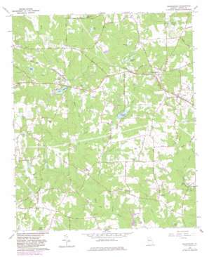
Sharpsburg Topo Map Georgia
To zoom in, hover over the map of Sharpsburg
USGS Topo Quad 33084c6 - 1:24,000 scale
| Topo Map Name: | Sharpsburg |
| USGS Topo Quad ID: | 33084c6 |
| Print Size: | ca. 21 1/4" wide x 27" high |
| Southeast Coordinates: | 33.25° N latitude / 84.625° W longitude |
| Map Center Coordinates: | 33.3125° N latitude / 84.6875° W longitude |
| U.S. State: | GA |
| Filename: | o33084c6.jpg |
| Download Map JPG Image: | Sharpsburg topo map 1:24,000 scale |
| Map Type: | Topographic |
| Topo Series: | 7.5´ |
| Map Scale: | 1:24,000 |
| Source of Map Images: | United States Geological Survey (USGS) |
| Alternate Map Versions: |
Sharpsburg GA 1965, updated 1967 Download PDF Buy paper map Sharpsburg GA 1965, updated 1983 Download PDF Buy paper map Sharpsburg GA 2011 Download PDF Buy paper map Sharpsburg GA 2014 Download PDF Buy paper map |
1:24,000 Topo Quads surrounding Sharpsburg
> Back to 33084a1 at 1:100,000 scale
> Back to 33084a1 at 1:250,000 scale
> Back to U.S. Topo Maps home
Sharpsburg topo map: Gazetteer
Sharpsburg: Dams
Chandlers Lake Dam elevation 251m 823′Clearwater Lake Dam elevation 243m 797′
Cole Lake Dam elevation 253m 830′
Lake Raymond Dam elevation 239m 784′
New Rainwater Lake Dam elevation 245m 803′
North Paradise Lake Dam elevation 274m 898′
North Steward Lake Dam elevation 260m 853′
Reese Lake Dam elevation 247m 810′
South Paradise Lake Dam elevation 270m 885′
South Steward Lake Dam elevation 265m 869′
West Steward Lake Dam elevation 265m 869′
Sharpsburg: Lakes
Hunter Pond elevation 262m 859′Sharpsburg: Populated Places
Bexton elevation 277m 908′Blackjack elevation 267m 875′
Elders Mill elevation 256m 839′
Oak Ridge elevation 275m 902′
Pope Hills Estate elevation 272m 892′
Raymond elevation 244m 800′
Sharpsburg elevation 282m 925′
Turin elevation 276m 905′
Sharpsburg: Reservoirs
Banks Lake elevation 262m 859′Beavers Lake elevation 263m 862′
Chandlers Lake elevation 251m 823′
Clearwater Lake elevation 243m 797′
Cole Lake elevation 253m 830′
Couch Lake elevation 244m 800′
Cox Lake elevation 253m 830′
Elders Millpond elevation 239m 784′
Hughie Lake elevation 254m 833′
Lake Raymond elevation 240m 787′
Neal Pond elevation 276m 905′
New Rainwater Lake elevation 245m 803′
North Paradise Lake elevation 274m 898′
North Steward Lake elevation 260m 853′
Paradise Lakes elevation 268m 879′
Rainwater Lake elevation 241m 790′
Reese Lake elevation 247m 810′
South Paradise Lake elevation 270m 885′
South Steward Lake elevation 265m 869′
Stevens Lake elevation 247m 810′
Steward Lakes elevation 265m 869′
West Steward Lake elevation 265m 869′
Whitelock Lake elevation 263m 862′
Whites Pond elevation 273m 895′
Sharpsburg: Streams
Chandlers Creek elevation 237m 777′Linch Branch elevation 243m 797′
Little White Oak Creek elevation 233m 764′
Pete Branch elevation 243m 797′
Pine Creek elevation 237m 777′
Sullivan Branch elevation 243m 797′
Turkey Creek elevation 231m 757′
Turkey Creek elevation 240m 787′
Whatley Branch elevation 225m 738′
Sharpsburg digital topo map on disk
Buy this Sharpsburg topo map showing relief, roads, GPS coordinates and other geographical features, as a high-resolution digital map file on DVD:


