Newnan South Topo Map Georgia
To zoom in, hover over the map of Newnan South
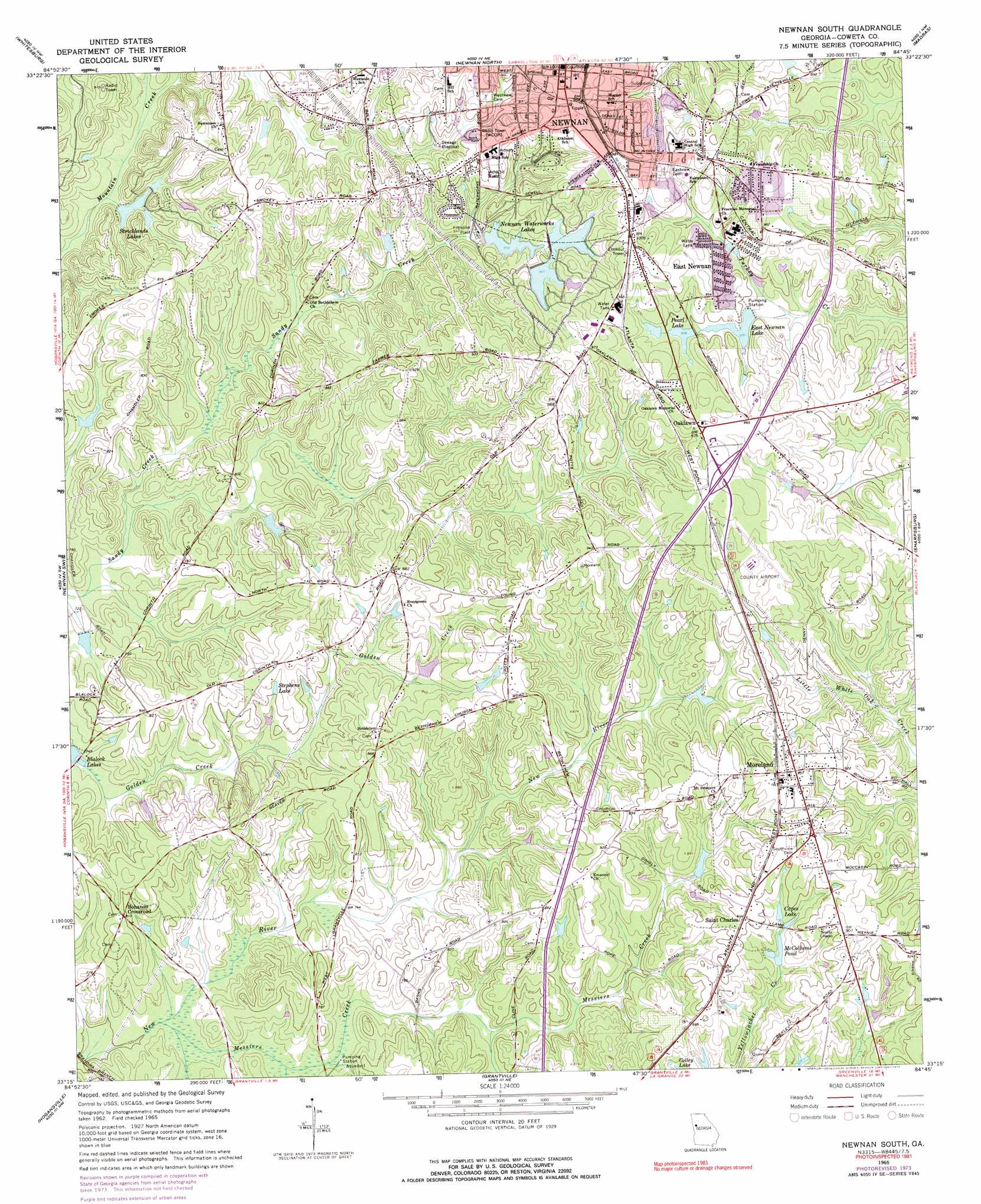
USGS Topo Quad 33084c7 - 1:24,000 scale
| Topo Map Name: | Newnan South |
| USGS Topo Quad ID: | 33084c7 |
| Print Size: | ca. 21 1/4" wide x 27" high |
| Southeast Coordinates: | 33.25° N latitude / 84.75° W longitude |
| Map Center Coordinates: | 33.3125° N latitude / 84.8125° W longitude |
| U.S. State: | GA |
| Filename: | o33084c7.jpg |
| Download Map JPG Image: | Newnan South topo map 1:24,000 scale |
| Map Type: | Topographic |
| Topo Series: | 7.5´ |
| Map Scale: | 1:24,000 |
| Source of Map Images: | United States Geological Survey (USGS) |
| Alternate Map Versions: |
Newnan South GA 1965, updated 1966 Download PDF Buy paper map Newnan South GA 1965, updated 1974 Download PDF Buy paper map Newnan South GA 1965, updated 1974 Download PDF Buy paper map Newnan South GA 2011 Download PDF Buy paper map Newnan South GA 2014 Download PDF Buy paper map |
1:24,000 Topo Quads surrounding Newnan South
Carrollton |
Hulett |
Rico |
Palmetto |
Fairburn |
Lowell |
Whitesburg |
Newnan North |
Madras |
Tyrone |
Franklin |
Newnan Sw |
Newnan South |
Sharpsburg |
Senoia |
Hillcrest |
Hogansville |
Grantville |
Luthersville |
Haralson |
La Grange |
Mountville |
Odessadale |
Greenville |
Gay |
> Back to 33084a1 at 1:100,000 scale
> Back to 33084a1 at 1:250,000 scale
> Back to U.S. Topo Maps home
Newnan South topo map: Gazetteer
Newnan South: Airports
Murphys Landing Airport elevation 241m 790′Newnan-Coweta County Airport elevation 290m 951′
Newnan South: Dams
Ambrose Lake Dam elevation 226m 741′East Newnan Lake Dam elevation 275m 902′
Lassetter Lake Dam elevation 235m 770′
Newman Waterworks Dam Number Two elevation 267m 875′
Newnan Water and Light Lake Number Four Dam elevation 283m 928′
Newnan Water and Light Lake Number Six Dam elevation 283m 928′
Newnan Waterworks Dam Number 5 elevation 286m 938′
Newnan Waterworks Dam Number One elevation 249m 816′
Newnan Waterworks Dam Number Three elevation 275m 902′
Pearl Lake Dam elevation 276m 905′
Smith Lake Dam elevation 253m 830′
Strickland Lake Dam elevation 228m 748′
Ware Lake Dam elevation 235m 770′
Newnan South: Parks
General Joe Wheeler Monument elevation 242m 793′Greenville Street-La Grange Street Historic District elevation 300m 984′
Newnan South: Populated Places
Bohanon Crossroad elevation 246m 807′Cedar Trace elevation 245m 803′
Cureton Springs (historical) elevation 244m 800′
East Newnan elevation 276m 905′
Hearthstone Subdivision elevation 263m 862′
Moreland elevation 285m 935′
Oaklawn elevation 294m 964′
Pine Hills elevation 275m 902′
Quail Hollow Mobile Home Park elevation 272m 892′
Saint Charles elevation 275m 902′
Smith City elevation 285m 935′
Smokey Acres elevation 275m 902′
Stephens Crossroad elevation 269m 882′
Timberland Trail Subdivision elevation 265m 869′
Woodsmoke elevation 258m 846′
Newnan South: Post Offices
Newnan Post Office elevation 301m 987′Newnan South: Reservoirs
Ambrose Lake elevation 226m 741′Capes Lake elevation 262m 859′
East Newnan Lake elevation 275m 902′
Lassetter Lake elevation 235m 770′
McCollums Pond elevation 258m 846′
Newnan Water and Light Lake Number Four elevation 283m 928′
Newnan Water and Light Lake Number Six elevation 283m 928′
Newnan Waterworks Lakes elevation 279m 915′
Newnan Waterworks Reservoir Number 5 elevation 286m 938′
Newnan Waterworks Reservoir Number One elevation 249m 816′
Newnan Waterworks Reservoir Number Three elevation 275m 902′
Newnan Waterworks Reservoir Number Two elevation 267m 875′
Pearl Lake elevation 276m 905′
Smith Lake elevation 253m 830′
Stephens Lake elevation 243m 797′
Strickland Lake elevation 228m 748′
Stricklands Lakes elevation 229m 751′
Ware Lake elevation 235m 770′
Newnan South: Springs
Pearl Springs elevation 276m 905′Newnan South: Streams
Messiers Creek elevation 214m 702′Newnan South digital topo map on disk
Buy this Newnan South topo map showing relief, roads, GPS coordinates and other geographical features, as a high-resolution digital map file on DVD: