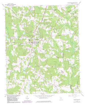
Fayetteville Topo Map Georgia
To zoom in, hover over the map of Fayetteville
USGS Topo Quad 33084d4 - 1:24,000 scale
| Topo Map Name: | Fayetteville |
| USGS Topo Quad ID: | 33084d4 |
| Print Size: | ca. 21 1/4" wide x 27" high |
| Southeast Coordinates: | 33.375° N latitude / 84.375° W longitude |
| Map Center Coordinates: | 33.4375° N latitude / 84.4375° W longitude |
| U.S. State: | GA |
| Filename: | o33084d4.jpg |
| Download Map JPG Image: | Fayetteville topo map 1:24,000 scale |
| Map Type: | Topographic |
| Topo Series: | 7.5´ |
| Map Scale: | 1:24,000 |
| Source of Map Images: | United States Geological Survey (USGS) |
| Alternate Map Versions: |
Fayetteville GA 1965, updated 1967 Download PDF Buy paper map Fayetteville GA 1965, updated 1983 Download PDF Buy paper map Fayetteville GA 2011 Download PDF Buy paper map Fayetteville GA 2014 Download PDF Buy paper map |
1:24,000 Topo Quads surrounding Fayetteville
> Back to 33084a1 at 1:100,000 scale
> Back to 33084a1 at 1:250,000 scale
> Back to U.S. Topo Maps home
Fayetteville topo map: Gazetteer
Fayetteville: Airports
Adams Airport elevation 269m 882′Bishops Airport elevation 263m 862′
McLendon Airport elevation 281m 921′
Walker Field elevation 264m 866′
Willow Pond Aviation Inc Airport elevation 256m 839′
Fayetteville: Bridges
Dixons Bridge elevation 236m 774′Gilbert Bridge elevation 242m 793′
Hills Bridge elevation 230m 754′
Fayetteville: Dams
Arrowhead East Dam elevation 243m 797′Arrowhead West Dam elevation 249m 816′
City of Fayetteville Lake Dam elevation 253m 830′
Fievet Lake Dam elevation 245m 803′
Ford Dam elevation 269m 882′
Fowler Dam elevation 255m 836′
Fowler Lake Dam elevation 248m 813′
Lake Bennett Dam elevation 244m 800′
Mills Dam elevation 249m 816′
Mundys Mill Dam elevation 246m 807′
Neelys Lake Dam elevation 256m 839′
Phillips Lake Dam elevation 253m 830′
Phillips Lake Dam West elevation 253m 830′
Pye Dam elevation 261m 856′
Sams Lake Dam elevation 248m 813′
Stinchcomb Lake Dam elevation 254m 833′
Thames Lake Dam elevation 244m 800′
Vickery Dam elevation 250m 820′
Walker Dam elevation 253m 830′
Wellborn Lake Dam elevation 248m 813′
Fayetteville: Populated Places
Beverly Manor elevation 267m 875′Blakely Woods elevation 276m 905′
Briarwood Park elevation 263m 862′
Brookcliff elevation 254m 833′
Calebs Meadows elevation 269m 882′
Chandler Acres elevation 274m 898′
Chanticleer elevation 266m 872′
Cottonwood elevation 283m 928′
Coventry Estates elevation 262m 859′
Cross Creek elevation 254m 833′
Deep Forest elevation 261m 856′
Deer Glen Forest elevation 262m 859′
Fayette Acres elevation 282m 925′
Fayetteville elevation 286m 938′
Fenwyck elevation 279m 915′
Fernway Estates elevation 275m 902′
Forest Estates elevation 254m 833′
Forest Hills elevation 268m 879′
Ginger Hills elevation 274m 898′
Greenlea elevation 267m 875′
Gregory Estates elevation 275m 902′
Harp elevation 287m 941′
Hickory Acres elevation 280m 918′
Huntington Creek elevation 266m 872′
Huntington South elevation 268m 879′
Inman elevation 267m 875′
Keyland Woods elevation 279m 915′
Kingswood elevation 279m 915′
Lakeview Estates elevation 257m 843′
Marilyn Acres elevation 273m 895′
Marion elevation 278m 912′
McIntosh Village elevation 260m 853′
Medford Manor elevation 276m 905′
Mitchell Estates elevation 284m 931′
Mundys Mill elevation 257m 843′
Oak Hills elevation 287m 941′
Ponderosa elevation 272m 892′
Quail Hollow elevation 255m 836′
Rest (historical) elevation 271m 889′
Rolling Meadows Estates elevation 250m 820′
Shannon elevation 248m 813′
Sharon Heights elevation 267m 875′
Tunis Trace elevation 263m 862′
Wellington Manor elevation 272m 892′
Whipporwill Ridge elevation 265m 869′
Windsor Estates elevation 264m 866′
Winterthur Woods elevation 262m 859′
Fayetteville: Post Offices
Fayetteville Post Office elevation 283m 928′Inman Post Office elevation 268m 879′
Fayetteville: Reservoirs
Arrowhead Lake elevation 243m 797′Arrowhead Lakes elevation 249m 816′
City of Fayetteville Lake elevation 253m 830′
Fievet Lake elevation 245m 803′
Ford Lake elevation 269m 882′
Fowler Lake elevation 248m 813′
Fowler Lake elevation 255m 836′
Indian Lake elevation 253m 830′
Lake Bennett elevation 244m 800′
Lake Fayette elevation 262m 859′
Mills Lake elevation 249m 816′
Mundys Mill Pond elevation 243m 797′
Mundys Millpond elevation 246m 807′
Neelys Lake elevation 256m 839′
Phillips Lake elevation 253m 830′
Phillips Lake West elevation 253m 830′
Pye Lake elevation 261m 856′
Sams Lake elevation 248m 813′
Stinchcomb Lake elevation 254m 833′
Thames Lake elevation 244m 800′
Vickery Lake elevation 250m 820′
Walker Lake elevation 253m 830′
Wellborn Lake elevation 248m 813′
Fayetteville: Streams
Beaverdam Creek elevation 240m 787′Camp Creek elevation 241m 790′
Gay Creek elevation 230m 754′
Geese Chant Creek elevation 230m 754′
Ginger Cake Creek elevation 235m 770′
Hurricane Creek elevation 234m 767′
Morning Creek elevation 237m 777′
Murphy Creek elevation 230m 754′
Nash Creek elevation 236m 774′
Sandy Creek elevation 244m 800′
Shoal Creek elevation 231m 757′
Swamp Creek elevation 240m 787′
Fayetteville digital topo map on disk
Buy this Fayetteville topo map showing relief, roads, GPS coordinates and other geographical features, as a high-resolution digital map file on DVD:


