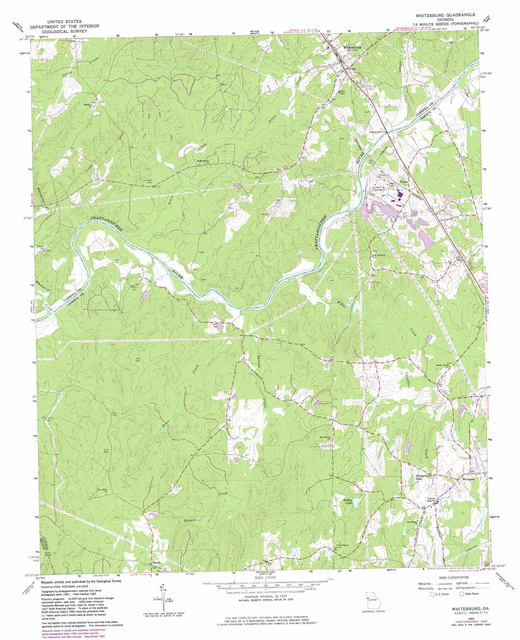
Whitesburg Topo Map Georgia
To zoom in, hover over the map of Whitesburg
USGS Topo Quad 33084d8 - 1:24,000 scale
| Topo Map Name: | Whitesburg |
| USGS Topo Quad ID: | 33084d8 |
| Print Size: | ca. 21 1/4" wide x 27" high |
| Southeast Coordinates: | 33.375° N latitude / 84.875° W longitude |
| Map Center Coordinates: | 33.4375° N latitude / 84.9375° W longitude |
| U.S. State: | GA |
| Filename: | o33084d8.jpg |
| Download Map JPG Image: | Whitesburg topo map 1:24,000 scale |
| Map Type: | Topographic |
| Topo Series: | 7.5´ |
| Map Scale: | 1:24,000 |
| Source of Map Images: | United States Geological Survey (USGS) |
| Alternate Map Versions: |
Whitesburg GA 1965, updated 1966 Download PDF Buy paper map Whitesburg GA 1965, updated 1983 Download PDF Buy paper map Whitesburg GA 2011 Download PDF Buy paper map Whitesburg GA 2014 Download PDF Buy paper map |
1:24,000 Topo Quads surrounding Whitesburg
Bremen |
Temple |
Villa Rica |
Winston |
Campbellton |
Bowdon East |
Carrollton |
Hulett |
Rico |
Palmetto |
Roopville |
Lowell |
Whitesburg |
Newnan North |
Madras |
Frolona |
Franklin |
Newnan Sw |
Newnan South |
Sharpsburg |
Glenn |
Hillcrest |
Hogansville |
Grantville |
Luthersville |
> Back to 33084a1 at 1:100,000 scale
> Back to 33084a1 at 1:250,000 scale
> Back to U.S. Topo Maps home
Whitesburg topo map: Gazetteer
Whitesburg: Bridges
Jones Bridge (historical) elevation 209m 685′Whitesburg: Crossings
New Ferry (historical) elevation 209m 685′Whitesburg: Dams
Kimbrough Lake Dam elevation 231m 757′Whitesburg: Lakes
Lewis Lakes (historical) elevation 207m 679′Whitesburg: Populated Places
Handy elevation 259m 849′Whitesburg elevation 259m 849′
Yates elevation 238m 780′
Whitesburg: Reservoirs
Bridgehaven Lake elevation 250m 820′Kimbrough Lake elevation 231m 757′
McKay Lake elevation 241m 790′
Whitesburg: Streams
Acorn Creek elevation 203m 666′Cavender Creek elevation 219m 718′
Cedar Creek elevation 211m 692′
Moore Creek elevation 205m 672′
Snake Creek elevation 211m 692′
Thomas Creek elevation 205m 672′
Wahoo Creek elevation 207m 679′
Whooping Creek elevation 202m 662′
Whitesburg digital topo map on disk
Buy this Whitesburg topo map showing relief, roads, GPS coordinates and other geographical features, as a high-resolution digital map file on DVD: