Stockbridge Topo Map Georgia
To zoom in, hover over the map of Stockbridge
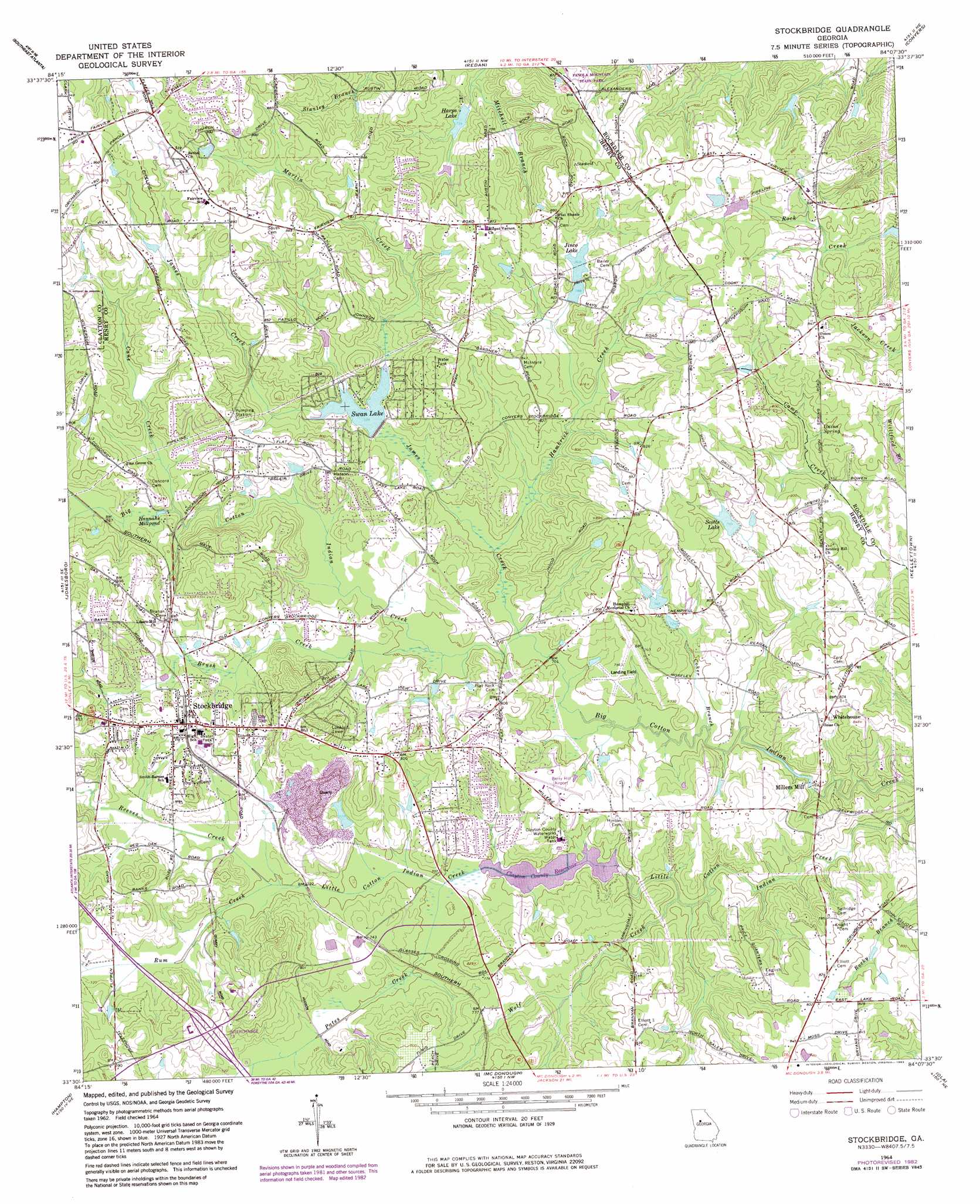
USGS Topo Quad 33084e2 - 1:24,000 scale
| Topo Map Name: | Stockbridge |
| USGS Topo Quad ID: | 33084e2 |
| Print Size: | ca. 21 1/4" wide x 27" high |
| Southeast Coordinates: | 33.5° N latitude / 84.125° W longitude |
| Map Center Coordinates: | 33.5625° N latitude / 84.1875° W longitude |
| U.S. State: | GA |
| Filename: | o33084e2.jpg |
| Download Map JPG Image: | Stockbridge topo map 1:24,000 scale |
| Map Type: | Topographic |
| Topo Series: | 7.5´ |
| Map Scale: | 1:24,000 |
| Source of Map Images: | United States Geological Survey (USGS) |
| Alternate Map Versions: |
Stockbridge GA 1964, updated 1966 Download PDF Buy paper map Stockbridge GA 1964, updated 1974 Download PDF Buy paper map Stockbridge GA 1964, updated 1983 Download PDF Buy paper map Stockbridge GA 2011 Download PDF Buy paper map Stockbridge GA 2014 Download PDF Buy paper map |
1:24,000 Topo Quads surrounding Stockbridge
Northwest Atlanta |
Northeast Atlanta |
Stone Mountain |
Snellville |
Loganville |
Southwest Atlanta |
Southeast Atlanta |
Redan |
Conyers |
Milstead |
Riverdale |
Jonesboro |
Stockbridge |
Kelleytown |
Porterdale |
Fayetteville |
Hampton |
Mcdonough |
Ola |
Worthville |
Brooks |
Griffin North |
Luella |
Locust Grove |
Jackson |
> Back to 33084e1 at 1:100,000 scale
> Back to 33084a1 at 1:250,000 scale
> Back to U.S. Topo Maps home
Stockbridge topo map: Gazetteer
Stockbridge: Airports
Berry Hill Airport elevation 227m 744′Gorden E Bellah International Airport elevation 225m 738′
Grant Airport elevation 233m 764′
Jims Private Airport elevation 263m 862′
Stockbridge: Crossings
Interchange 73 elevation 245m 803′Stockbridge: Dams
Agresearch Lake Dam elevation 252m 826′Clayton County Reservoir Dam elevation 209m 685′
Dailey Dam elevation 236m 774′
Ingram Dam elevation 245m 803′
Ingram Lake Dam elevation 245m 803′
Lower Haizlip Lake Dam elevation 250m 820′
Pine Wood Shores Lake Dam elevation 269m 882′
Scotts Dam elevation 231m 757′
Swan Lake Dam elevation 223m 731′
Upper Haizlip Lake Dam elevation 259m 849′
Vulcan Materials Quarry Lake Dam elevation 223m 731′
Stockbridge: Mines
Mathers Quarry elevation 235m 770′Stockbridge Quarry elevation 245m 803′
Stockbridge: Parks
Cochran Park elevation 229m 751′Richardson Park elevation 260m 853′
Stockbridge: Populated Places
Autumn Chase elevation 281m 921′Belair Woods elevation 242m 793′
Belmount Farms elevation 290m 951′
Brannan elevation 216m 708′
Bridgewood elevation 229m 751′
Brownwood elevation 242m 793′
Brownwood Acres elevation 238m 780′
Carriage Trace elevation 241m 790′
Chimney Ridge elevation 232m 761′
Circle Creek elevation 225m 738′
Club Drive elevation 248m 813′
Colonial Coach Estates elevation 270m 885′
Cotton Indian Creek elevation 240m 787′
Country Roads elevation 258m 846′
Dove Rest elevation 261m 856′
Duval elevation 228m 748′
Fairfield Glen elevation 277m 908′
Fairview Manor elevation 260m 853′
Fairview Station elevation 293m 961′
Fay (historical) elevation 287m 941′
Flakes Crossing elevation 223m 731′
Flintlook elevation 260m 853′
Hidden Lakes elevation 235m 770′
Hidden Valley elevation 251m 823′
Highland Village elevation 223m 731′
Knob (historical) elevation 277m 908′
Mahers (historical) elevation 232m 761′
Martin Creek Country Estates elevation 248m 813′
Millers Mill elevation 212m 695′
Oakhill elevation 256m 839′
Oakwood Manor elevation 242m 793′
Parkwood elevation 236m 774′
Patillo Point elevation 252m 826′
Pine Valley Estates elevation 233m 764′
Pinecrest elevation 244m 800′
Pinehurst elevation 257m 843′
Richardson elevation 260m 853′
Ridgecrest elevation 239m 784′
Southbridge elevation 230m 754′
Springfield Acres elevation 241m 790′
Springwood Valley elevation 270m 885′
Stockbridge elevation 244m 800′
Stockbridge North elevation 254m 833′
Stokes Crossing elevation 258m 846′
Swan Lake elevation 235m 770′
Tunis (historical) elevation 238m 780′
Whitehouse elevation 245m 803′
Woodhaven Estates elevation 238m 780′
Stockbridge: Post Offices
Stockbridge Post Office elevation 249m 816′Stockbridge: Reservoirs
Agresearch Lake elevation 252m 826′Clayton County Reservoir elevation 209m 685′
Dailey Lake elevation 236m 774′
Hannahs Millpond elevation 223m 731′
Harps Lake elevation 224m 734′
Ingram Lake elevation 245m 803′
Ingrams Lake elevation 245m 803′
Jinco Lake elevation 244m 800′
Lower Haizlip Lake elevation 250m 820′
Pine Wood Shores Lake elevation 269m 882′
Scotts Lake elevation 231m 757′
Swan Lake elevation 223m 731′
Upper Haizlip Lake elevation 259m 849′
Vulcan Materials Quarry Lake elevation 223m 731′
Stockbridge: Springs
Union Spring elevation 235m 770′Stockbridge: Streams
Brush Creek elevation 210m 688′Cane Creek elevation 221m 725′
Coker Branch elevation 207m 679′
Hambrick Creek elevation 209m 685′
James Creek elevation 209m 685′
Martin Creek elevation 225m 738′
Pates Creek elevation 211m 692′
Reeves Creek elevation 210m 688′
Rum Creek elevation 211m 692′
Wolf Creek elevation 207m 679′
Stockbridge digital topo map on disk
Buy this Stockbridge topo map showing relief, roads, GPS coordinates and other geographical features, as a high-resolution digital map file on DVD: