Villa Rica Topo Map Georgia
To zoom in, hover over the map of Villa Rica
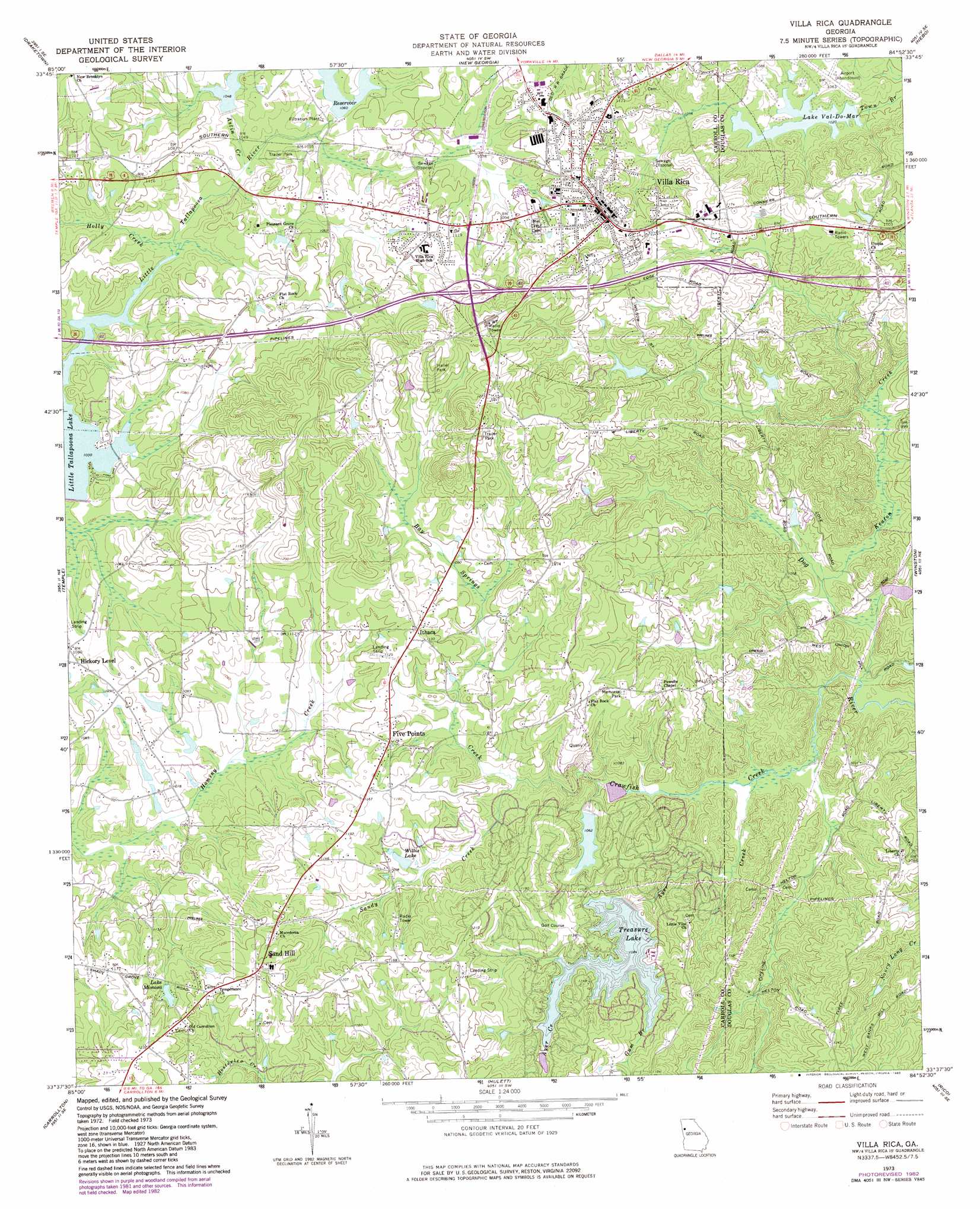
USGS Topo Quad 33084f8 - 1:24,000 scale
| Topo Map Name: | Villa Rica |
| USGS Topo Quad ID: | 33084f8 |
| Print Size: | ca. 21 1/4" wide x 27" high |
| Southeast Coordinates: | 33.625° N latitude / 84.875° W longitude |
| Map Center Coordinates: | 33.6875° N latitude / 84.9375° W longitude |
| U.S. State: | GA |
| Filename: | o33084f8.jpg |
| Download Map JPG Image: | Villa Rica topo map 1:24,000 scale |
| Map Type: | Topographic |
| Topo Series: | 7.5´ |
| Map Scale: | 1:24,000 |
| Source of Map Images: | United States Geological Survey (USGS) |
| Alternate Map Versions: |
Villa Rica GA 1973, updated 1975 Download PDF Buy paper map Villa Rica GA 1973, updated 1983 Download PDF Buy paper map Villa Rica GA 2011 Download PDF Buy paper map Villa Rica GA 2014 Download PDF Buy paper map |
1:24,000 Topo Quads surrounding Villa Rica
Felton |
Rockmart South |
Yorkville |
Dallas |
Lost Mountain |
Buchanan |
Draketown |
New Georgia |
Nebo |
Austell |
Bremen |
Temple |
Villa Rica |
Winston |
Campbellton |
Bowdon East |
Carrollton |
Hulett |
Rico |
Palmetto |
Roopville |
Lowell |
Whitesburg |
Newnan North |
Madras |
> Back to 33084e1 at 1:100,000 scale
> Back to 33084a1 at 1:250,000 scale
> Back to U.S. Topo Maps home
Villa Rica topo map: Gazetteer
Villa Rica: Airports
Diamond R Ranch Airport elevation 353m 1158′Hickory Level Airfield elevation 326m 1069′
Villa Rica: Crossings
Exit 5 elevation 363m 1190′Exit 6 elevation 346m 1135′
Villa Rica: Dams
Fishing Lake Dam elevation 311m 1020′Hudson Lake Dam elevation 320m 1049′
Lake Val-Do-Mar Dam elevation 304m 997′
Lake Val-Do-Mar Dam Number Two elevation 311m 1020′
Little Tallapoosa Structure 29 Dam elevation 324m 1062′
Little Tallapoosa Structure 31 Dam elevation 320m 1049′
Sims Dam elevation 312m 1023′
Treasure Lake Dam elevation 319m 1046′
Villa Rica Water Works Lake Dam elevation 335m 1099′
Willis Lake Dam elevation 329m 1079′
Villa Rica: Lakes
Lake Val-Do-Mar elevation 304m 997′Villa Rica: Mines
Chambers Mine elevation 335m 1099′Hart Mine elevation 324m 1062′
Jones Mine elevation 335m 1099′
Villa Rica Quarry elevation 347m 1138′
Villa Rica: Populated Places
Chestnut Hill (historical) elevation 389m 1276′Driskolls elevation 331m 1085′
Five Points elevation 345m 1131′
Flying S Ranchettes elevation 321m 1053′
Hart Town elevation 321m 1053′
Ithaca elevation 348m 1141′
Old Villa Rica elevation 342m 1122′
Paradise Estates elevation 328m 1076′
Sand Hill elevation 372m 1220′
Villa Rica elevation 347m 1138′
Villa Rica: Post Offices
Villa Rica Post Office elevation 342m 1122′Villa Rica: Reservoirs
Fishing Lake elevation 311m 1020′Hudson Lake elevation 320m 1049′
Lake Mimosa elevation 355m 1164′
Lake Val-Do Mar elevation 311m 1020′
Lake Val-Do-Mar elevation 309m 1013′
Muse Lake elevation 320m 1049′
Payne Lakes elevation 318m 1043′
Sims Lake elevation 312m 1023′
Treasure Lake elevation 319m 1046′
Tumlin Lake elevation 324m 1062′
Villa Rica Water Works Lake elevation 335m 1099′
Willis Lake elevation 329m 1079′
Villa Rica: Streams
Astin Creek elevation 316m 1036′Ayer Creek elevation 289m 948′
Bay Springs Creek elevation 314m 1030′
Crawfish Creek elevation 282m 925′
Gum Branch elevation 330m 1082′
Holly Creek elevation 315m 1033′
Keaton Creek elevation 286m 938′
Sandy Creek elevation 314m 1030′
Villa Rica: Summits
William Mountain elevation 419m 1374′Villa Rica digital topo map on disk
Buy this Villa Rica topo map showing relief, roads, GPS coordinates and other geographical features, as a high-resolution digital map file on DVD: