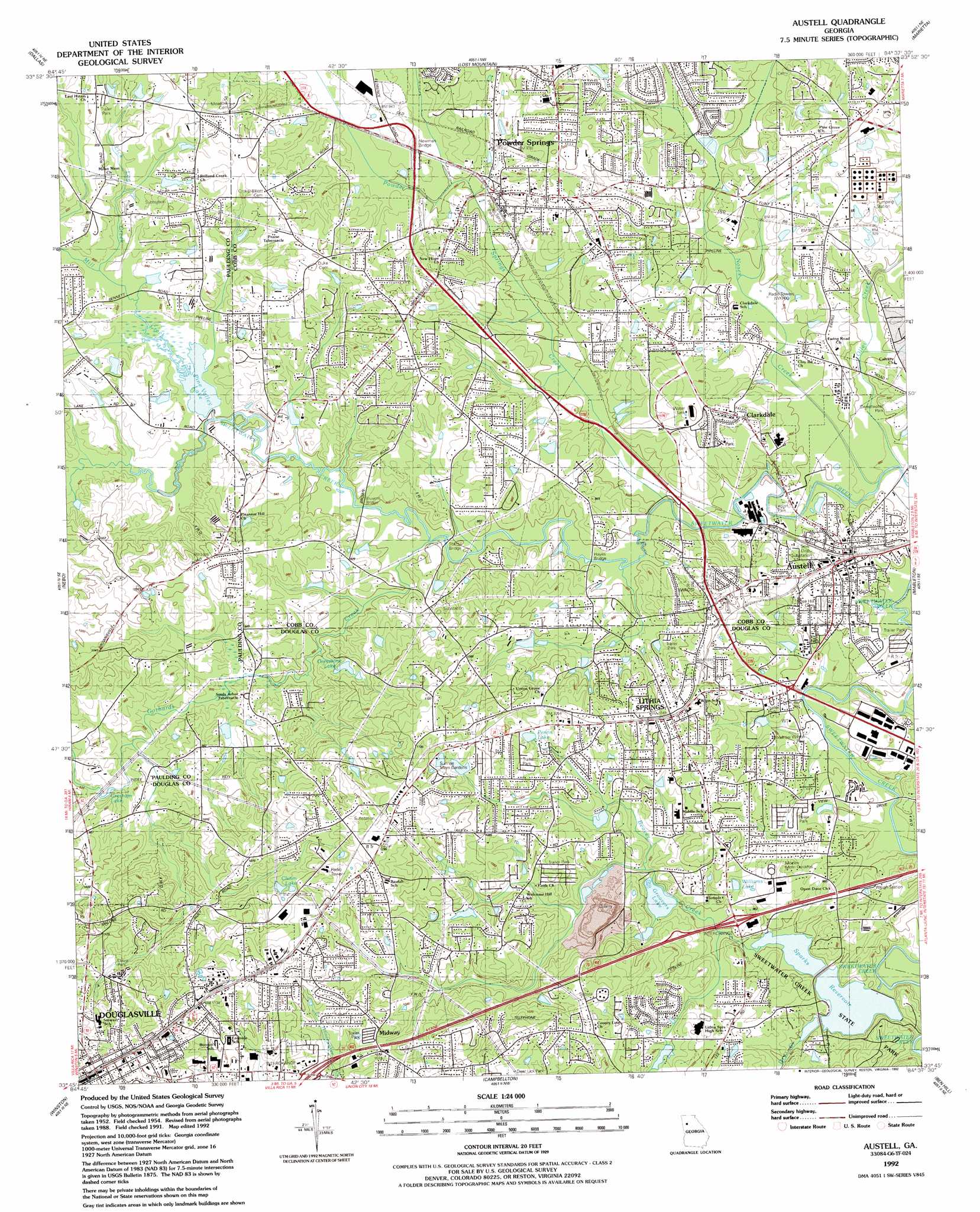
Austell Topo Map Georgia
To zoom in, hover over the map of Austell
USGS Topo Quad 33084g6 - 1:24,000 scale
| Topo Map Name: | Austell |
| USGS Topo Quad ID: | 33084g6 |
| Print Size: | ca. 21 1/4" wide x 27" high |
| Southeast Coordinates: | 33.75° N latitude / 84.625° W longitude |
| Map Center Coordinates: | 33.8125° N latitude / 84.6875° W longitude |
| U.S. State: | GA |
| Filename: | o33084g6.jpg |
| Download Map JPG Image: | Austell topo map 1:24,000 scale |
| Map Type: | Topographic |
| Topo Series: | 7.5´ |
| Map Scale: | 1:24,000 |
| Source of Map Images: | United States Geological Survey (USGS) |
| Alternate Map Versions: |
Austell GA 1954, updated 1956 Download PDF Buy paper map Austell GA 1954, updated 1968 Download PDF Buy paper map Austell GA 1954, updated 1969 Download PDF Buy paper map Austell GA 1954, updated 1974 Download PDF Buy paper map Austell GA 1954, updated 1983 Download PDF Buy paper map Austell GA 1992, updated 1992 Download PDF Buy paper map Austell GA 1999, updated 2003 Download PDF Buy paper map Austell GA 2011 Download PDF Buy paper map Austell GA 2014 Download PDF Buy paper map |
1:24,000 Topo Quads surrounding Austell
Tayorsville |
Burnt Hickory Ridge |
Acworth |
Kennesaw |
Mountain Park |
Yorkville |
Dallas |
Lost Mountain |
Marietta |
Sandy Springs |
New Georgia |
Nebo |
Austell |
Mableton |
Northwest Atlanta |
Villa Rica |
Winston |
Campbellton |
Ben Hill |
Southwest Atlanta |
Hulett |
Rico |
Palmetto |
Fairburn |
Riverdale |
> Back to 33084e1 at 1:100,000 scale
> Back to 33084a1 at 1:250,000 scale
> Back to U.S. Topo Maps home
Austell topo map: Gazetteer
Austell: Bridges
Browns Bridge elevation 272m 892′Newman Bridge elevation 285m 935′
Stansil Bridge elevation 271m 889′
Austell: Crossings
Interchange 10 elevation 323m 1059′Interchange 11 elevation 280m 918′
Austell: Dams
Clark Lake Dam elevation 288m 944′Coats and Clark Dam elevation 271m 889′
George H Sparks Reservoir Dam Number 2 elevation 269m 882′
George H Sparks Reservoir Dam Number One elevation 262m 859′
Groovers Lake Dam elevation 275m 902′
Pine Valley Lake Dam elevation 275m 902′
Vaughn Lake Dam elevation 322m 1056′
Austell: Lakes
Gresham Lake elevation 280m 918′Austell: Mines
Lithia Springs Quarry elevation 238m 780′Austell: Parks
Beulah Park elevation 316m 1036′Clarkdale Historic District elevation 293m 961′
Clarkdale Park elevation 287m 941′
Collar Park elevation 289m 948′
Douglasville Commercial Historic District elevation 368m 1207′
Legion Park elevation 269m 882′
Powder Springs Park elevation 273m 895′
Sweetwater Creek State Park elevation 269m 882′
Sweetwater Park elevation 280m 918′
Wortham Park elevation 368m 1207′
Austell: Populated Places
Anna Bella Estates elevation 311m 1020′Ansley Park elevation 306m 1003′
Austell elevation 283m 928′
Bannister Acres elevation 296m 971′
Beech Gum Mobile Home Park elevation 286m 938′
Beechwood Hills elevation 291m 954′
Beulah elevation 360m 1181′
Boulder Park Estates elevation 310m 1017′
Brannons Branch elevation 276m 905′
Brook Forest Mobile Home Park elevation 269m 882′
Brookstone elevation 281m 921′
Brookwood Acres elevation 294m 964′
Burnt Hickory Estates elevation 280m 918′
Burnt Hickory Farms elevation 293m 961′
Clarkdale elevation 291m 954′
Colonial Estates elevation 330m 1082′
Connally elevation 349m 1145′
County Line Heights elevation 332m 1089′
County Line Place elevation 329m 1079′
Cumberland Forest elevation 292m 958′
Deerbrook Estates elevation 304m 997′
Deerfield elevation 283m 928′
Douglasville elevation 366m 1200′
Durelle elevation 336m 1102′
Ellis elevation 354m 1161′
English Heights elevation 342m 1122′
Fairfax elevation 309m 1013′
Falcon Acres elevation 286m 938′
Forest Acres elevation 277m 908′
Forest Glen elevation 285m 935′
Forest Heights elevation 339m 1112′
Forkwood elevation 294m 964′
Foxboro elevation 299m 980′
Georgian Heights elevation 302m 990′
Greenfield Chase elevation 305m 1000′
Harpers Lake elevation 292m 958′
Heritage Square elevation 302m 990′
Hickory Forest elevation 336m 1102′
Hickory Glen elevation 300m 984′
High Point elevation 309m 1013′
Hillsdale Heights elevation 285m 935′
Indian Rose elevation 286m 938′
James Heights elevation 292m 958′
Kellogg elevation 346m 1135′
Killarney Hills elevation 324m 1062′
Lake Estates elevation 285m 935′
Lakeland Hills elevation 323m 1059′
Lakeside Mobile Home Park elevation 320m 1049′
Lawrence Estates elevation 273m 895′
Leeward Park elevation 294m 964′
Leisure Acres elevation 287m 941′
Lithia Mobile Home Estates elevation 294m 964′
Lithia Springs elevation 318m 1043′
Malone Park elevation 347m 1138′
Mann Manor elevation 299m 980′
McKenny Acres elevation 351m 1151′
McKown elevation 328m 1076′
Merlin Meadows elevation 330m 1082′
Midway elevation 330m 1082′
Midway Estates elevation 333m 1092′
Midway Mobile Home Park elevation 325m 1066′
North Kingsley Estates elevation 286m 938′
Oak Hill elevation 311m 1020′
Paris Manor elevation 296m 971′
Park Forest elevation 314m 1030′
Park Place elevation 287m 941′
Parkway Estates elevation 338m 1108′
Pine Oaks elevation 291m 954′
Pine Valley Estates elevation 293m 961′
Pinebrook Mobile Home Park elevation 326m 1069′
Pinecrest Estates elevation 287m 941′
Pineview elevation 322m 1056′
Plantation Estates Mobile Home Park elevation 333m 1092′
Pleasant Hills elevation 299m 980′
Powder Ridge elevation 286m 938′
Powder Springs elevation 288m 944′
Powder Springs Chase elevation 297m 974′
Rocky Hills elevation 308m 1010′
Sherwood Park elevation 300m 984′
Skyview elevation 296m 971′
Skyview Heights elevation 309m 1013′
Southern Pines Estates elevation 322m 1056′
Springbrook elevation 286m 938′
Springtime Mobile Home Park elevation 309m 1013′
Steeplechase elevation 294m 964′
Stonewood elevation 313m 1026′
Stoneybrook elevation 307m 1007′
Sullivan Heights elevation 288m 944′
Sunset Hill elevation 330m 1082′
Tammy Heights elevation 297m 974′
The Willows elevation 332m 1089′
Trail Creek elevation 296m 971′
Walker Place elevation 336m 1102′
Wasilla Estates elevation 306m 1003′
Wesley Station elevation 275m 902′
West Springs elevation 291m 954′
Westridge elevation 294m 964′
Wexford Estates elevation 348m 1141′
Whitaker Hills elevation 305m 1000′
Young Park elevation 310m 1017′
Austell: Post Offices
Austell Post Office elevation 286m 938′Clarkdale Post Office elevation 291m 954′
Lithia Springs Post Office elevation 316m 1036′
Powder Springs Post Office elevation 294m 964′
Austell: Reservoirs
Chism Lake elevation 330m 1082′Clark Lake elevation 288m 944′
Coats and Clark Lake elevation 271m 889′
George H Sparks Reservoir elevation 262m 859′
George H Sparks Reservoir elevation 269m 882′
Greystone Lake elevation 296m 971′
Groovers Lake elevation 275m 902′
Penns Lake elevation 310m 1017′
Pine Valley Lake elevation 275m 902′
Shues Lake elevation 289m 948′
Vaughn Lake elevation 322m 1056′
Williams Lake elevation 285m 935′
Austell: Streams
Dry Creek elevation 274m 898′Gothards Creek elevation 272m 892′
Lick Log Creek elevation 278m 912′
Mill Creek elevation 274m 898′
Noses Creek elevation 267m 875′
Olley Creek elevation 269m 882′
Powder Springs Creek elevation 268m 879′
Austell digital topo map on disk
Buy this Austell topo map showing relief, roads, GPS coordinates and other geographical features, as a high-resolution digital map file on DVD: