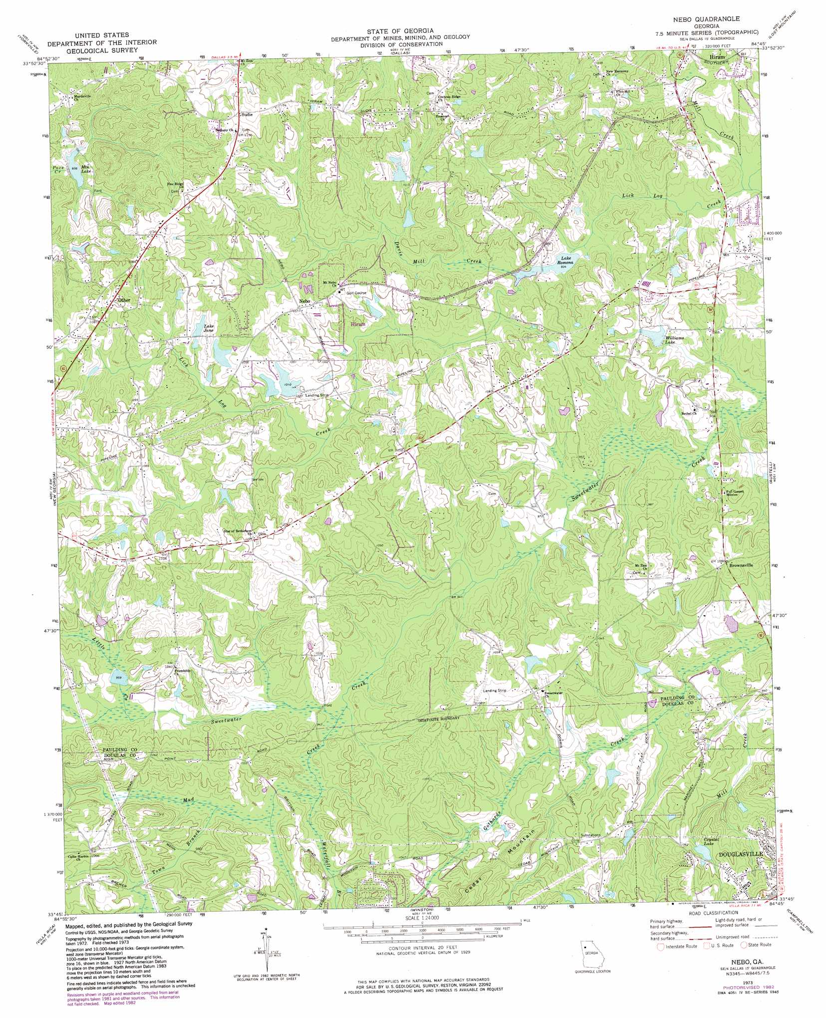
Nebo Topo Map Georgia
To zoom in, hover over the map of Nebo
USGS Topo Quad 33084g7 - 1:24,000 scale
| Topo Map Name: | Nebo |
| USGS Topo Quad ID: | 33084g7 |
| Print Size: | ca. 21 1/4" wide x 27" high |
| Southeast Coordinates: | 33.75° N latitude / 84.75° W longitude |
| Map Center Coordinates: | 33.8125° N latitude / 84.8125° W longitude |
| U.S. State: | GA |
| Filename: | o33084g7.jpg |
| Download Map JPG Image: | Nebo topo map 1:24,000 scale |
| Map Type: | Topographic |
| Topo Series: | 7.5´ |
| Map Scale: | 1:24,000 |
| Source of Map Images: | United States Geological Survey (USGS) |
| Alternate Map Versions: |
Nebo GA 1973, updated 1975 Download PDF Buy paper map Nebo GA 1973, updated 1983 Download PDF Buy paper map Nebo GA 2011 Download PDF Buy paper map Nebo GA 2014 Download PDF Buy paper map |
1:24,000 Topo Quads surrounding Nebo
Rockmart North |
Tayorsville |
Burnt Hickory Ridge |
Acworth |
Kennesaw |
Rockmart South |
Yorkville |
Dallas |
Lost Mountain |
Marietta |
Draketown |
New Georgia |
Nebo |
Austell |
Mableton |
Temple |
Villa Rica |
Winston |
Campbellton |
Ben Hill |
Carrollton |
Hulett |
Rico |
Palmetto |
Fairburn |
> Back to 33084e1 at 1:100,000 scale
> Back to 33084a1 at 1:250,000 scale
> Back to U.S. Topo Maps home
Nebo topo map: Gazetteer
Nebo: Airports
Pinewood Airport elevation 324m 1062′Nebo: Dams
Crystal Lake Dam elevation 324m 1062′Douglas Lake Dam elevation 302m 990′
Ellis Lake Dam elevation 306m 1003′
Hatcher Lake Dam elevation 311m 1020′
Hatcher Lake East Dam elevation 311m 1020′
Jones Lake Dam elevation 306m 1003′
Jones Lake Dam elevation 298m 977′
Lake Jane Dam elevation 312m 1023′
Lake Romona Dam elevation 285m 935′
McCravy Lake Dam elevation 300m 984′
Pumpkinvine Creek Structure Number 26 Dam elevation 286m 938′
Williams Lake Dam elevation 293m 961′
Nebo: Mines
Roach Prospect elevation 311m 1020′Nebo: Populated Places
Arbor Walk elevation 325m 1066′Asbury Woods elevation 336m 1102′
Ash elevation 337m 1105′
Ashley Acres elevation 311m 1020′
Bakers Bridge Estates elevation 332m 1089′
Baldwin Hills elevation 324m 1062′
Black Forest elevation 294m 964′
Bromley Estates elevation 299m 980′
Brownsville elevation 321m 1053′
Campground School Estates elevation 325m 1066′
Colonial Hills elevation 299m 980′
Corn Crib Mobile Home Park elevation 336m 1102′
Country Club Estates elevation 302m 990′
Deer Run elevation 287m 941′
Denton Estates elevation 327m 1072′
Denton Farms elevation 312m 1023′
Emerald Forest elevation 338m 1108′
Fleetwood Hills elevation 336m 1102′
Gordon Estates elevation 334m 1095′
Green Meadows elevation 291m 954′
Greenfield Summit elevation 348m 1141′
Hartfield Acres elevation 338m 1108′
Hartfield Estates elevation 338m 1108′
Hollyberry elevation 322m 1056′
Home Place Acres elevation 337m 1105′
Honeysuckle Plantation elevation 347m 1138′
Joseph Estates elevation 348m 1141′
Lake Swan elevation 320m 1049′
Lincoln Heights elevation 343m 1125′
Meadowbrook elevation 311m 1020′
Mill Creek Place elevation 318m 1043′
Mountainview Estates elevation 329m 1079′
Nebo elevation 325m 1066′
Nebo Gardens elevation 310m 1017′
Nebo Place elevation 331m 1085′
Oak Creek elevation 342m 1122′
Oberlochen elevation 320m 1049′
Old Davis Mill Estates elevation 318m 1043′
Paces Lakes elevation 341m 1118′
Paces Meadows elevation 330m 1082′
Pilgrim North elevation 319m 1046′
Pine Forest elevation 347m 1138′
Quail Run elevation 341m 1118′
Quail Run East elevation 329m 1079′
Ridge Corners elevation 341m 1118′
Ridgeview Heights elevation 324m 1062′
South Paulding Woods elevation 314m 1030′
Sprayberry Farms elevation 304m 997′
Spring Ridge Estates elevation 331m 1085′
Sudie elevation 340m 1115′
Swan Lake elevation 306m 1003′
Sweetwater Estates elevation 324m 1062′
The Highlands elevation 312m 1023′
The South Forty elevation 300m 984′
Victoria Cove elevation 352m 1154′
Westwood Heights elevation 324m 1062′
Nebo: Reservoirs
Aiken Lake elevation 292m 958′Crystal Lake elevation 324m 1062′
Ellis Lake elevation 306m 1003′
Hatcher Lake elevation 311m 1020′
Hatcher Lake East elevation 311m 1020′
Jones Lake elevation 306m 1003′
Jones Lake elevation 298m 977′
Lake Douglas elevation 302m 990′
Lake Jane elevation 312m 1023′
Lake Romona elevation 285m 935′
McCravy Lake elevation 300m 984′
Mountain Lake elevation 286m 938′
Williams Lake elevation 293m 961′
Nebo: Streams
Davis Mill Creek elevation 284m 931′Lick Log Creek elevation 278m 912′
Little Creek elevation 289m 948′
Mill Creek elevation 277m 908′
Mud Creek elevation 283m 928′
Town Branch elevation 289m 948′
Waterfall Branch elevation 285m 935′
Nebo digital topo map on disk
Buy this Nebo topo map showing relief, roads, GPS coordinates and other geographical features, as a high-resolution digital map file on DVD: