New Site Topo Map Alabama
To zoom in, hover over the map of New Site
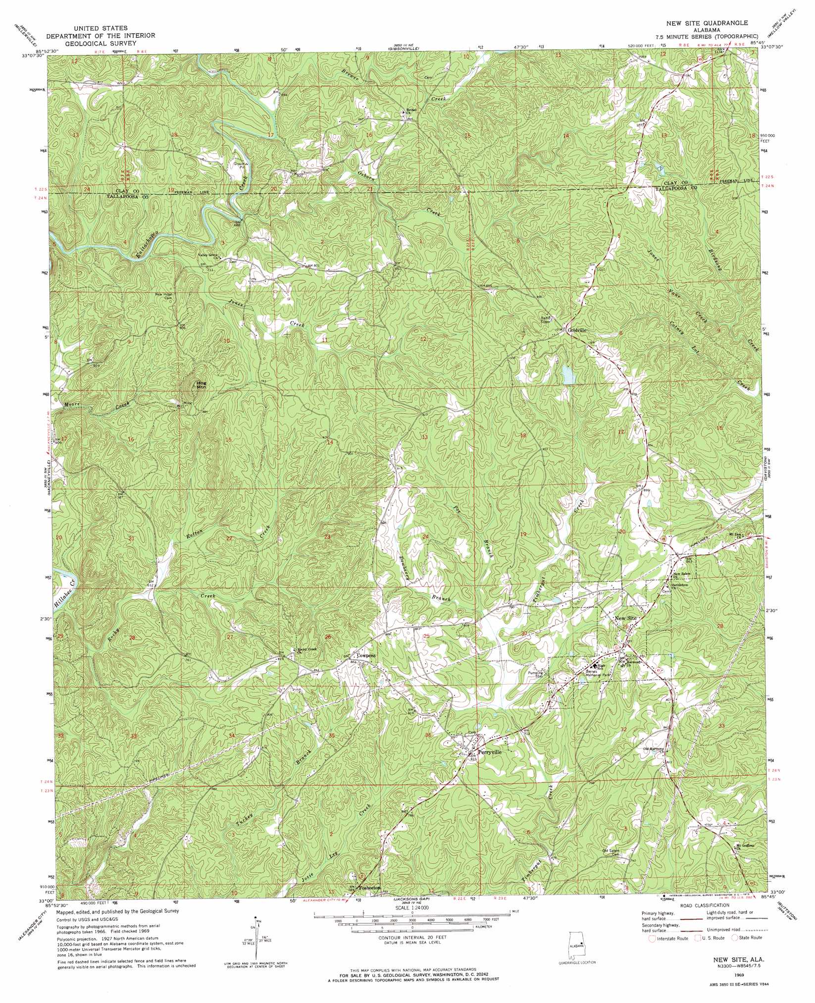
USGS Topo Quad 33085a7 - 1:24,000 scale
| Topo Map Name: | New Site |
| USGS Topo Quad ID: | 33085a7 |
| Print Size: | ca. 21 1/4" wide x 27" high |
| Southeast Coordinates: | 33° N latitude / 85.75° W longitude |
| Map Center Coordinates: | 33.0625° N latitude / 85.8125° W longitude |
| U.S. State: | AL |
| Filename: | o33085a7.jpg |
| Download Map JPG Image: | New Site topo map 1:24,000 scale |
| Map Type: | Topographic |
| Topo Series: | 7.5´ |
| Map Scale: | 1:24,000 |
| Source of Map Images: | United States Geological Survey (USGS) |
| Alternate Map Versions: |
New Site AL 1969, updated 1973 Download PDF Buy paper map New Site AL 2011 Download PDF Buy paper map New Site AL 2014 Download PDF Buy paper map |
1:24,000 Topo Quads surrounding New Site
Porter Gap |
Clairmont Springs |
Lineville West |
Lineville East |
Ofelia |
Bulls Gap |
Millerville |
Gibsonville |
Mellow Valley |
Wadley North |
Goodwater |
Hackneyville |
New Site |
Daviston |
Wadley South |
Kellyton |
Alexander City |
Jacksons Gap |
Buttston |
Dudleyville |
Equality |
Our Town |
Dadeville |
Camp Hill |
Camp Hill Se |
> Back to 33085a1 at 1:100,000 scale
> Back to 33084a1 at 1:250,000 scale
> Back to U.S. Topo Maps home
New Site topo map: Gazetteer
New Site: Areas
Piedmont Upland elevation 222m 728′New Site: Dams
Patterson Dam elevation 284m 931′Whatley Dam elevation 243m 797′
New Site: Mines
Hog Mountain Goldmine elevation 260m 853′New Site: Parks
Barnes Memorial Park elevation 247m 810′New Site: Populated Places
Bethleham (historical) elevation 265m 869′Cowpens elevation 264m 866′
Goldville elevation 308m 1010′
Harmony (historical) elevation 252m 826′
New Site elevation 270m 885′
Perryville elevation 246m 807′
New Site: Reservoirs
Patterson Lake elevation 284m 931′Whatley Pond elevation 243m 797′
New Site: Springs
Reedy Spring elevation 238m 780′New Site: Streams
Brewer Creek elevation 212m 695′Cotney Lot Creek elevation 225m 738′
Dewberry Branch elevation 222m 728′
Jones Creek elevation 203m 666′
Jones Vane Creek elevation 239m 784′
Kennedy Branch elevation 218m 715′
Osborn Creek elevation 208m 682′
Poe Branch elevation 221m 725′
Rocky Creek elevation 170m 557′
Rotton Creek elevation 181m 593′
New Site: Summits
Hog Mountain elevation 333m 1092′New Site digital topo map on disk
Buy this New Site topo map showing relief, roads, GPS coordinates and other geographical features, as a high-resolution digital map file on DVD: