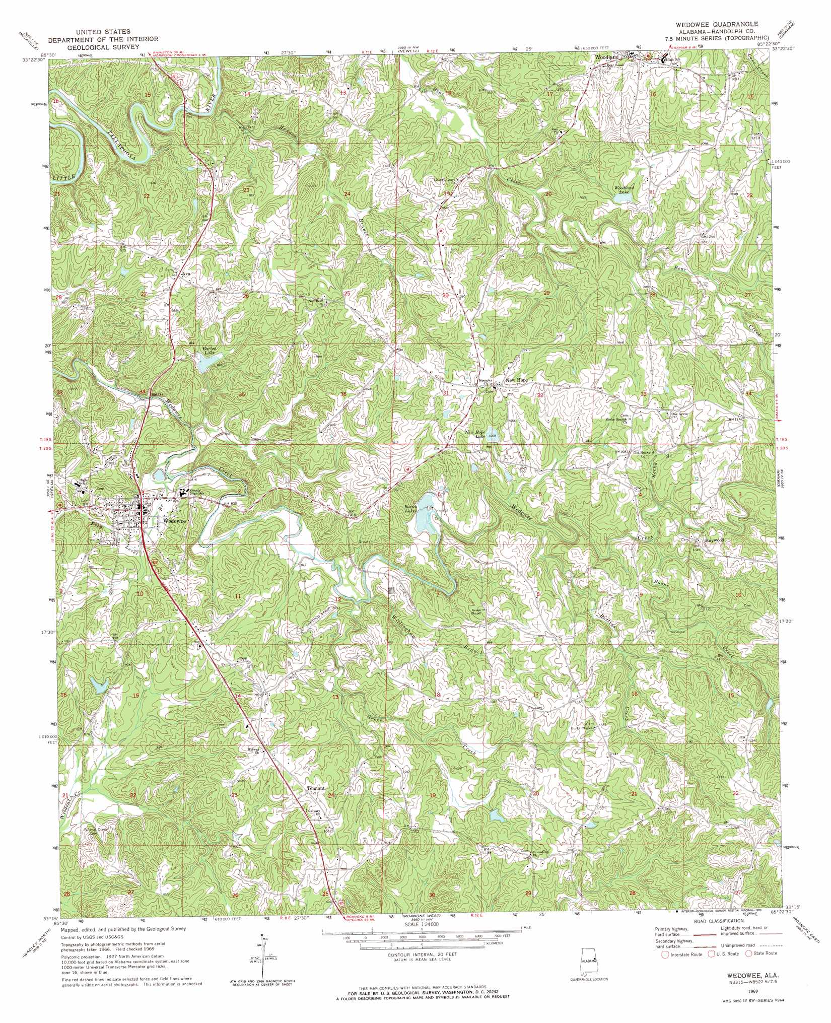
Wedowee Topo Map Alabama
To zoom in, hover over the map of Wedowee
USGS Topo Quad 33085c4 - 1:24,000 scale
| Topo Map Name: | Wedowee |
| USGS Topo Quad ID: | 33085c4 |
| Print Size: | ca. 21 1/4" wide x 27" high |
| Southeast Coordinates: | 33.25° N latitude / 85.375° W longitude |
| Map Center Coordinates: | 33.3125° N latitude / 85.4375° W longitude |
| U.S. State: | AL |
| Filename: | o33085c4.jpg |
| Download Map JPG Image: | Wedowee topo map 1:24,000 scale |
| Map Type: | Topographic |
| Topo Series: | 7.5´ |
| Map Scale: | 1:24,000 |
| Source of Map Images: | United States Geological Survey (USGS) |
| Alternate Map Versions: |
Wedowee AL 1969, updated 1973 Download PDF Buy paper map Wedowee AL 2011 Download PDF Buy paper map Wedowee AL 2014 Download PDF Buy paper map |
1:24,000 Topo Quads surrounding Wedowee
Hollis Crossroads |
Ross Mountain |
Hightower |
Bowdon West |
Bowdon East |
Delta |
Micaville |
Newell |
Graham |
Roopville |
Lineville East |
Ofelia |
Wedowee |
Napoleon |
Frolona |
Mellow Valley |
Wadley North |
Roanoke West |
Roanoke East |
Glenn |
Daviston |
Wadley South |
Milltown |
Five Points |
Abbottsford |
> Back to 33085a1 at 1:100,000 scale
> Back to 33084a1 at 1:250,000 scale
> Back to U.S. Topo Maps home
Wedowee topo map: Gazetteer
Wedowee: Crossings
McBurnett Ford (historical) elevation 295m 967′Wedowee: Dams
Burns Number 2 Dam elevation 281m 921′Carpenter Dam elevation 290m 951′
McCain Dam elevation 284m 931′
McManus Dam elevation 308m 1010′
New Hope Dam elevation 305m 1000′
Strain Dam elevation 302m 990′
Wedowee Club Lake Dam elevation 272m 892′
Wedowee: Populated Places
Ava elevation 293m 961′Corbin elevation 306m 1003′
Curt elevation 284m 931′
Haywood elevation 319m 1046′
Hobson elevation 335m 1099′
Liberty Grove elevation 304m 997′
Midway elevation 317m 1040′
Mount Pleasant elevation 309m 1013′
New Hope elevation 340m 1115′
Peace elevation 336m 1102′
Rocky Branch elevation 337m 1105′
Tennant elevation 323m 1059′
Wedowee elevation 259m 849′
West elevation 342m 1122′
Woodland elevation 336m 1102′
Wedowee: Post Offices
Wedowee Post Office elevation 261m 856′Woodland Post Office elevation 335m 1099′
Wedowee: Reservoirs
Barton Lake elevation 259m 849′Burns Lake Number 2 elevation 281m 921′
Burns Lakes elevation 271m 889′
Carpenter Lake elevation 290m 951′
McManus Pond elevation 308m 1010′
New Hope Lake elevation 305m 1000′
Wedowee Club Lake elevation 272m 892′
Woodland Lake elevation 298m 977′
Wedowee: Streams
Boone Creek elevation 288m 944′Frog Level Branch elevation 240m 787′
Green Creek elevation 254m 833′
Henson Branch elevation 237m 777′
Mud Creek elevation 231m 757′
Rocky Branch elevation 291m 954′
Rollins Creek elevation 277m 908′
Willingham Branch elevation 255m 836′
Wedowee digital topo map on disk
Buy this Wedowee topo map showing relief, roads, GPS coordinates and other geographical features, as a high-resolution digital map file on DVD: