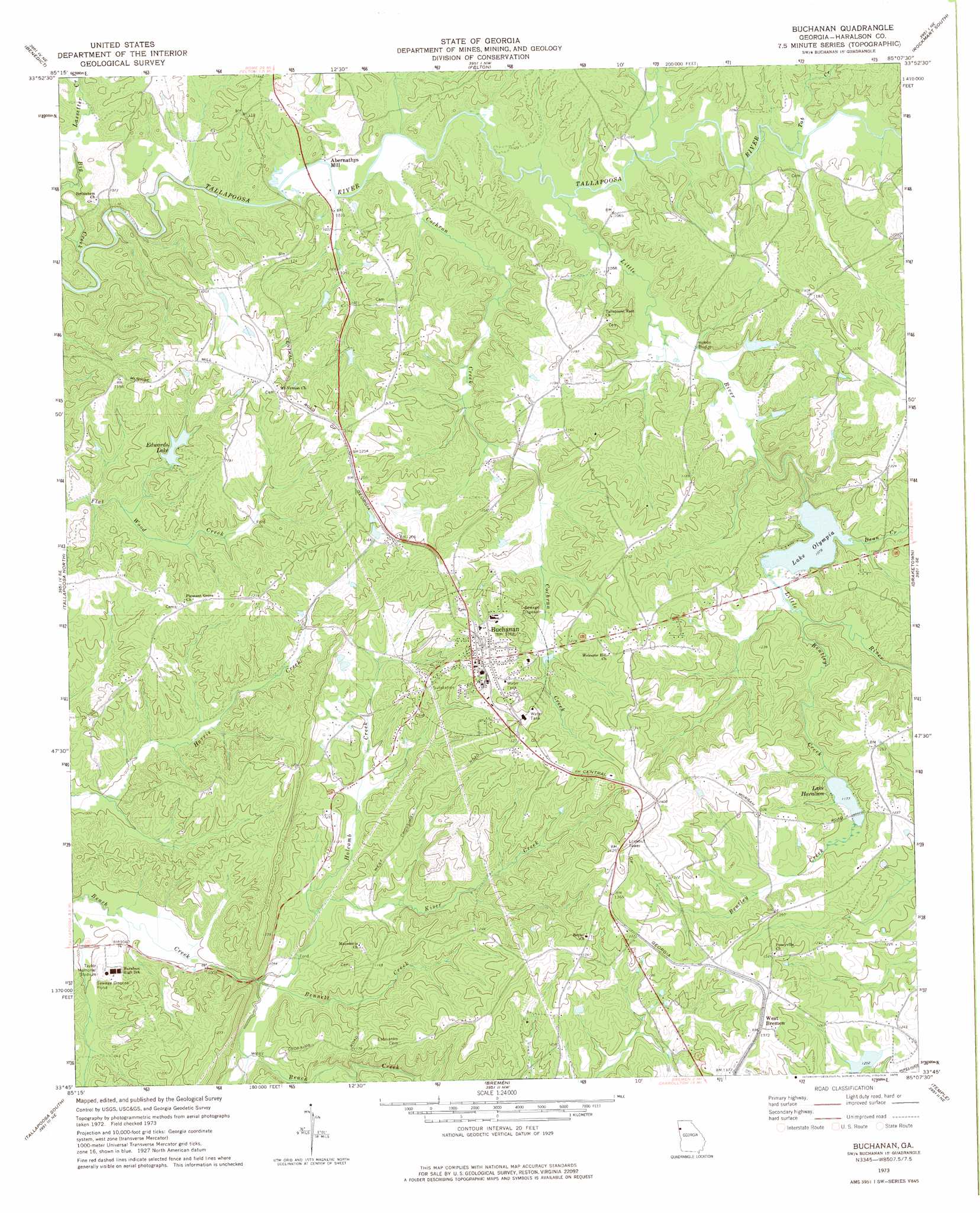
Buchanan Topo Map Georgia
To zoom in, hover over the map of Buchanan
USGS Topo Quad 33085g2 - 1:24,000 scale
| Topo Map Name: | Buchanan |
| USGS Topo Quad ID: | 33085g2 |
| Print Size: | ca. 21 1/4" wide x 27" high |
| Southeast Coordinates: | 33.75° N latitude / 85.125° W longitude |
| Map Center Coordinates: | 33.8125° N latitude / 85.1875° W longitude |
| U.S. State: | GA |
| Filename: | o33085g2.jpg |
| Download Map JPG Image: | Buchanan topo map 1:24,000 scale |
| Map Type: | Topographic |
| Topo Series: | 7.5´ |
| Map Scale: | 1:24,000 |
| Source of Map Images: | United States Geological Survey (USGS) |
| Alternate Map Versions: |
Buchanan GA 1973, updated 1975 Download PDF Buy paper map Buchanan GA 1973, updated 1975 Download PDF Buy paper map Buchanan GA 2011 Download PDF Buy paper map Buchanan GA 2014 Download PDF Buy paper map |
1:24,000 Topo Quads surrounding Buchanan
Indian Mountain |
Cedartown West |
Cedartown East |
Rockmart North |
Tayorsville |
Borden Springs |
Benedict |
Felton |
Rockmart South |
Yorkville |
Oak Level |
Tallapoosa North |
Buchanan |
Draketown |
New Georgia |
Fruithurst |
Tallapoosa South |
Bremen |
Temple |
Villa Rica |
Hightower |
Bowdon West |
Bowdon East |
Carrollton |
Hulett |
> Back to 33085e1 at 1:100,000 scale
> Back to 33084a1 at 1:250,000 scale
> Back to U.S. Topo Maps home
Buchanan topo map: Gazetteer
Buchanan: Bridges
Hobbs Bridge elevation 322m 1056′Buchanan: Dams
Binns Lake Dam elevation 330m 1082′Edwards Lake Dam elevation 334m 1095′
Lake Haralson Dam elevation 360m 1181′
Lake Olympia Dam elevation 329m 1079′
Little River Structure Number Two Dam elevation 372m 1220′
Buchanan: Parks
Taylor Memorial Stadium elevation 320m 1049′Buchanan: Populated Places
Abernathys Mill elevation 311m 1020′Buchanan elevation 379m 1243′
Latham (historical) elevation 318m 1043′
Tabernacle elevation 341m 1118′
West Bremen elevation 415m 1361′
Buchanan: Post Offices
Buchanan Post Office elevation 380m 1246′Buchanan: Reservoirs
Baxter Lake elevation 372m 1220′Binns Lake elevation 330m 1082′
Edwards Lake elevation 334m 1095′
Lake Haralson elevation 360m 1181′
Lake Olympia elevation 329m 1079′
Buchanan: Streams
Bennett Creek elevation 305m 1000′Bentley Creek elevation 335m 1099′
Big Creek elevation 305m 1000′
Cochran Creek elevation 313m 1026′
Dean Creek elevation 330m 1082′
Holcomb Creek elevation 305m 1000′
Kiser Creek elevation 311m 1020′
Lassetter Creek elevation 307m 1007′
Little River elevation 314m 1030′
Tab Creek elevation 317m 1040′
Buchanan digital topo map on disk
Buy this Buchanan topo map showing relief, roads, GPS coordinates and other geographical features, as a high-resolution digital map file on DVD: