Jacksonville East Topo Map Alabama
To zoom in, hover over the map of Jacksonville East
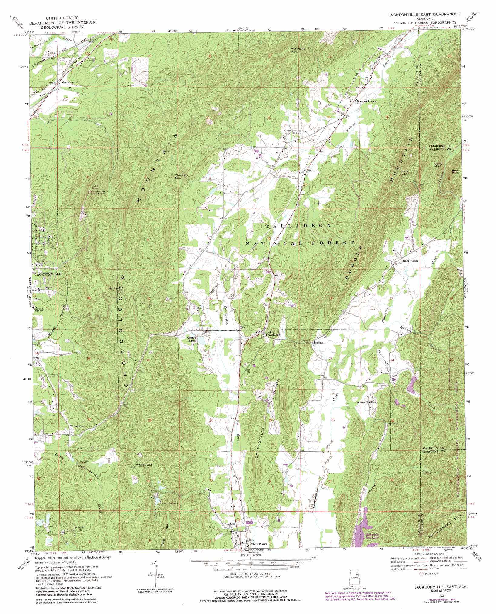
USGS Topo Quad 33085g6 - 1:24,000 scale
| Topo Map Name: | Jacksonville East |
| USGS Topo Quad ID: | 33085g6 |
| Print Size: | ca. 21 1/4" wide x 27" high |
| Southeast Coordinates: | 33.75° N latitude / 85.625° W longitude |
| Map Center Coordinates: | 33.8125° N latitude / 85.6875° W longitude |
| U.S. State: | AL |
| Filename: | o33085g6.jpg |
| Download Map JPG Image: | Jacksonville East topo map 1:24,000 scale |
| Map Type: | Topographic |
| Topo Series: | 7.5´ |
| Map Scale: | 1:24,000 |
| Source of Map Images: | United States Geological Survey (USGS) |
| Alternate Map Versions: |
Jacksonville East AL 1967, updated 1970 Download PDF Buy paper map Jacksonville East AL 1967, updated 1977 Download PDF Buy paper map Jacksonville East AL 1967, updated 1984 Download PDF Buy paper map Jacksonville East AL 1967, updated 1985 Download PDF Buy paper map Jacksonville East AL 1975, updated 1977 Download PDF Buy paper map Jacksonville East AL 2001, updated 2004 Download PDF Buy paper map Jacksonville East AL 2011 Download PDF Buy paper map Jacksonville East AL 2014 Download PDF Buy paper map |
| FStopo: | US Forest Service topo Jacksonville East is available: Download FStopo PDF Download FStopo TIF |
1:24,000 Topo Quads surrounding Jacksonville East
Gadsden East |
Ballplay |
Weisner Mountain |
Ellisville |
Indian Mountain |
Glencoe |
Colvin Gap |
Piedmont Nw |
Piedmont |
Borden Springs |
Wellington |
Jacksonville West |
Jacksonville East |
Piedmont Se |
Oak Level |
Eulaton |
Anniston |
Choccolocco |
Heflin |
Fruithurst |
Munford |
Oxford |
Hollis Crossroads |
Ross Mountain |
Hightower |
> Back to 33085e1 at 1:100,000 scale
> Back to 33084a1 at 1:250,000 scale
> Back to U.S. Topo Maps home
Jacksonville East topo map: Gazetteer
Jacksonville East: Bends
Carpenters Bend elevation 207m 679′Jacksonville East: Dams
Cottaquilla Dam elevation 303m 994′Shelton Dam elevation 250m 820′
Jacksonville East: Gaps
King Gap elevation 348m 1141′Rabbittown Gap elevation 325m 1066′
The Narrows elevation 253m 830′
Whites Gap elevation 384m 1259′
Jacksonville East: Populated Places
Hallingworth elevation 267m 875′Holley Crossroads elevation 260m 853′
Hollingsworth elevation 256m 839′
Jenkins elevation 240m 787′
Merrellton elevation 206m 675′
Nances Creek elevation 232m 761′
Rabbittown elevation 238m 780′
Whites Gap elevation 254m 833′
Jacksonville East: Reservoirs
Lake Cottaquilla elevation 303m 994′Shelton Lakes elevation 250m 820′
Jacksonville East: Ridges
Choccolocco Mountain elevation 436m 1430′Dugger Mountain elevation 356m 1167′
Jacksonville East: Springs
Browns Spring elevation 287m 941′Carpond Spring elevation 232m 761′
Easterwood Spring elevation 241m 790′
Roberts Spring elevation 241m 790′
Watsons Field Spring elevation 225m 738′
Watsons House Spring elevation 227m 744′
Whites Gap Spring elevation 248m 813′
Jacksonville East: Streams
Jones Branch elevation 231m 757′Murray Branch elevation 220m 721′
Rock House Branch elevation 226m 741′
Scarbrough Creek elevation 219m 718′
Jacksonville East: Summits
Ben White Point elevation 482m 1581′Berry Mountain elevation 447m 1466′
Chimney Mountain elevation 361m 1184′
Chimney Peak elevation 523m 1715′
Cottaquilla Mountain elevation 348m 1141′
Foster Mountain elevation 440m 1443′
Hurricane Mountain elevation 543m 1781′
Red Mountain elevation 456m 1496′
Jacksonville East digital topo map on disk
Buy this Jacksonville East topo map showing relief, roads, GPS coordinates and other geographical features, as a high-resolution digital map file on DVD: