Glencoe Topo Map Alabama
To zoom in, hover over the map of Glencoe
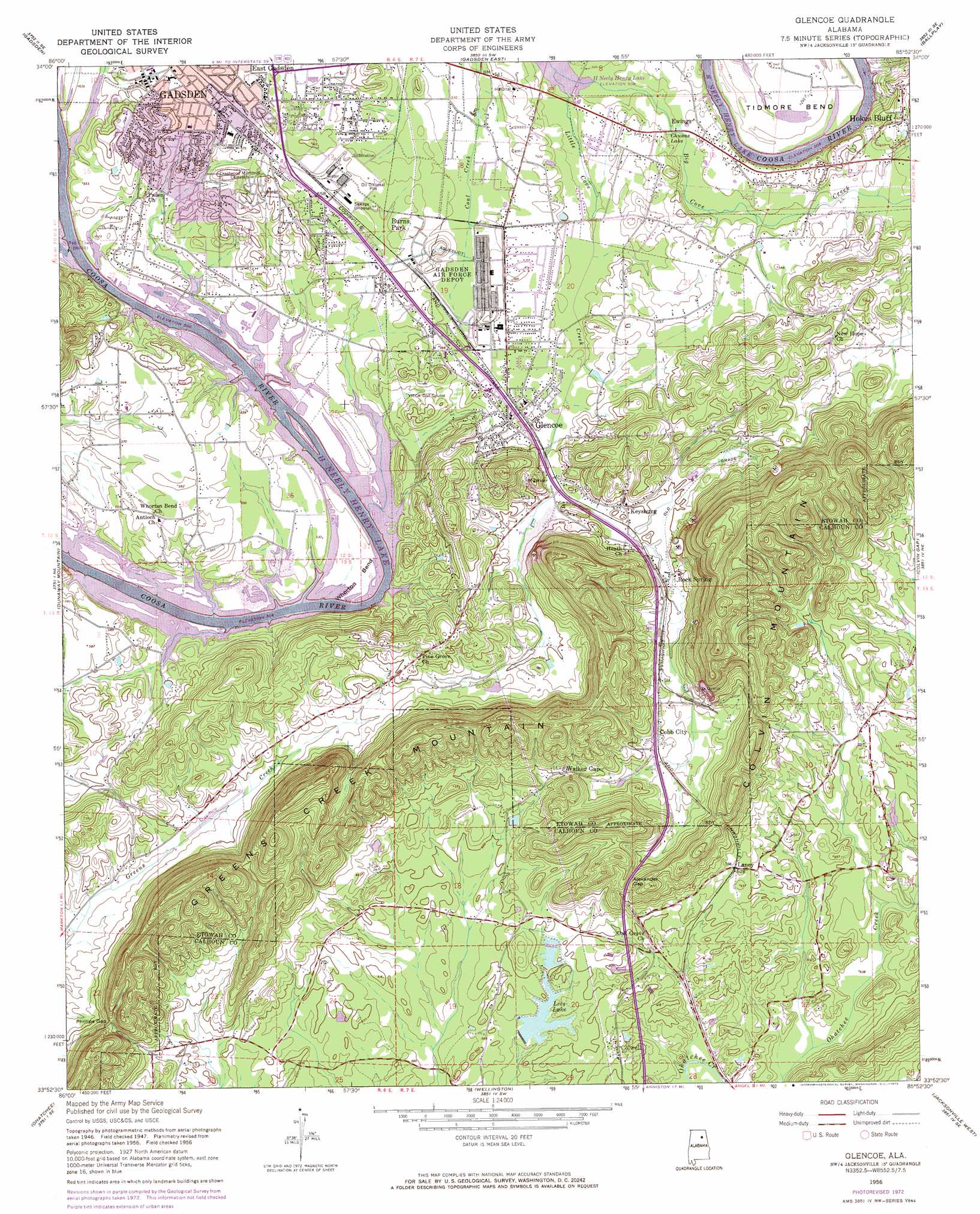
USGS Topo Quad 33085h8 - 1:24,000 scale
| Topo Map Name: | Glencoe |
| USGS Topo Quad ID: | 33085h8 |
| Print Size: | ca. 21 1/4" wide x 27" high |
| Southeast Coordinates: | 33.875° N latitude / 85.875° W longitude |
| Map Center Coordinates: | 33.9375° N latitude / 85.9375° W longitude |
| U.S. State: | AL |
| Filename: | o33085h8.jpg |
| Download Map JPG Image: | Glencoe topo map 1:24,000 scale |
| Map Type: | Topographic |
| Topo Series: | 7.5´ |
| Map Scale: | 1:24,000 |
| Source of Map Images: | United States Geological Survey (USGS) |
| Alternate Map Versions: |
Glencoe AL 1947, updated 1953 Download PDF Buy paper map Glencoe AL 1956, updated 1961 Download PDF Buy paper map Glencoe AL 1956, updated 1973 Download PDF Buy paper map Glencoe AL 1956, updated 1973 Download PDF Buy paper map Glencoe AL 2011 Download PDF Buy paper map Glencoe AL 2014 Download PDF Buy paper map |
1:24,000 Topo Quads surrounding Glencoe
Boaz |
Rodentown |
Keener |
Leesburg |
Centre |
Howelton |
Gadsden West |
Gadsden East |
Ballplay |
Weisner Mountain |
Steele |
Dunaway Mountain |
Glencoe |
Colvin Gap |
Piedmont Nw |
Cox Gap |
Ohatchee |
Wellington |
Jacksonville West |
Jacksonville East |
Ragland |
Francis Mill |
Eulaton |
Anniston |
Choccolocco |
> Back to 33085e1 at 1:100,000 scale
> Back to 33084a1 at 1:250,000 scale
> Back to U.S. Topo Maps home
Glencoe topo map: Gazetteer
Glencoe: Bends
Keeling Bend elevation 155m 508′Tidmore Bend elevation 162m 531′
Whorton Bend elevation 156m 511′
Glencoe: Crossings
Fowler Ferry (historical) elevation 161m 528′Hokes Bluff Ferry (historical) elevation 155m 508′
Glencoe: Dams
Lay Dam elevation 174m 570′Lee Dam elevation 172m 564′
Presbyterian Church Dam elevation 180m 590′
Glencoe: Gaps
Alexander Gap elevation 230m 754′Davis Gap elevation 207m 679′
Phillips Gap elevation 221m 725′
Glencoe: Islands
Keeling Island elevation 155m 508′Glencoe: Mines
Cobb Quarry elevation 207m 679′Glencoe Quarry elevation 181m 593′
Glencoe: Populated Places
Burns Park elevation 164m 538′Cobb City elevation 196m 643′
Colvin elevation 204m 669′
Colwell elevation 188m 616′
Douthrittville (historical) elevation 183m 600′
Ewing elevation 165m 541′
Glencoe elevation 172m 564′
Keysburg elevation 177m 580′
Laney elevation 192m 629′
Masingale (historical) elevation 156m 511′
Nisbit (historical) elevation 170m 557′
Oak Grove (historical) elevation 170m 557′
Oak Level elevation 182m 597′
Pine Grove elevation 231m 757′
Rock Spring elevation 180m 590′
Smiths Crossroads elevation 204m 669′
Glencoe: Post Offices
Calvin Grove Post Office (historical) elevation 186m 610′Masingale Post Office (historical) elevation 156m 511′
Nisbit Post Office (historical) elevation 170m 557′
Glencoe: Reservoirs
Chums Lake elevation 161m 528′Church Lake elevation 180m 590′
Lays Lake elevation 174m 570′
Lees Lake elevation 174m 570′
Glencoe: Springs
Glencoe Spring elevation 176m 577′Rock Spring elevation 179m 587′
Glencoe: Streams
Big Cove Creek elevation 155m 508′Little Cove Creek elevation 155m 508′
Glencoe: Summits
Greens Creek Mountain elevation 338m 1108′Glencoe: Valleys
Burns Valley elevation 195m 639′Glencoe digital topo map on disk
Buy this Glencoe topo map showing relief, roads, GPS coordinates and other geographical features, as a high-resolution digital map file on DVD: