Talladega Springs Topo Map Alabama
To zoom in, hover over the map of Talladega Springs
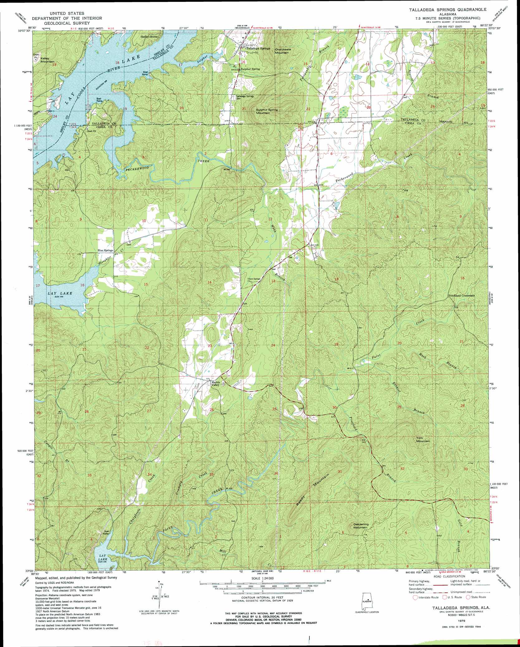
USGS Topo Quad 33086a4 - 1:24,000 scale
| Topo Map Name: | Talladega Springs |
| USGS Topo Quad ID: | 33086a4 |
| Print Size: | ca. 21 1/4" wide x 27" high |
| Southeast Coordinates: | 33° N latitude / 86.375° W longitude |
| Map Center Coordinates: | 33.0625° N latitude / 86.4375° W longitude |
| U.S. State: | AL |
| Filename: | o33086a4.jpg |
| Download Map JPG Image: | Talladega Springs topo map 1:24,000 scale |
| Map Type: | Topographic |
| Topo Series: | 7.5´ |
| Map Scale: | 1:24,000 |
| Source of Map Images: | United States Geological Survey (USGS) |
| Alternate Map Versions: |
Gantts Quarry SW AL 1975, updated 1977 Download PDF Buy paper map Talladega Springs AL 1979, updated 1980 Download PDF Buy paper map Talladega Springs AL 1979, updated 1980 Download PDF Buy paper map Talladega Springs AL 2011 Download PDF Buy paper map Talladega Springs AL 2014 Download PDF Buy paper map |
1:24,000 Topo Quads surrounding Talladega Springs
Chelsea |
Westover |
Harpersville |
Childersburg |
Winterboro |
Bounds Lake |
Columbiana |
Wilsonville |
Sylacauga West |
Sylacauga East |
Ozan |
Shelby |
Talladega Springs |
Weogufka |
Hollins |
Jemison East |
Lay Dam |
Mitchell Dam Nw |
Flag Mountain |
Rockford |
Clanton West |
Clanton East |
Mitchell Dam |
Richville |
Rockford Sw |
> Back to 33086a1 at 1:100,000 scale
> Back to 33086a1 at 1:250,000 scale
> Back to U.S. Topo Maps home
Talladega Springs topo map: Gazetteer
Talladega Springs: Bars
Peckerwood Shoals (historical) elevation 119m 390′Talladega Springs: Crossings
Chancellors Ferry (historical) elevation 222m 728′McGees Ferry (historical) elevation 119m 390′
Talladega Springs: Gaps
Sulphur Mountain Gap elevation 171m 561′Talladega Springs: Mines
Eureka Quarry elevation 141m 462′Talladega Springs: Populated Places
Blue Springs elevation 124m 406′Marble Valley elevation 158m 518′
Strickland Crossroads elevation 196m 643′
Sulphur Spring elevation 128m 419′
Talladega Springs elevation 131m 429′
Talladega Springs: Post Offices
Idella Post Office (historical) elevation 122m 400′Talladega Springs: Springs
Talladega Sulphur Springs elevation 128m 419′Talladega Springs: Streams
Chalybeate Creek elevation 119m 390′Crumply Creek elevation 123m 403′
Ezekiel Branch elevation 157m 515′
Mill Creek elevation 119m 390′
Peckerwood Creek elevation 119m 390′
Pinefiold Branch elevation 153m 501′
Rock Branch elevation 162m 531′
Slaughter Creek elevation 119m 390′
Sulphur Branch elevation 119m 390′
Webb Branch elevation 139m 456′
Talladega Springs: Summits
Chalybeate Mountain elevation 246m 807′Deadening Mountain elevation 282m 925′
Kelley Mountain elevation 220m 721′
Reedy Mountain elevation 268m 879′
Sulphur Spring Mountain elevation 262m 859′
York Mountain elevation 282m 925′
Talladega Springs digital topo map on disk
Buy this Talladega Springs topo map showing relief, roads, GPS coordinates and other geographical features, as a high-resolution digital map file on DVD: