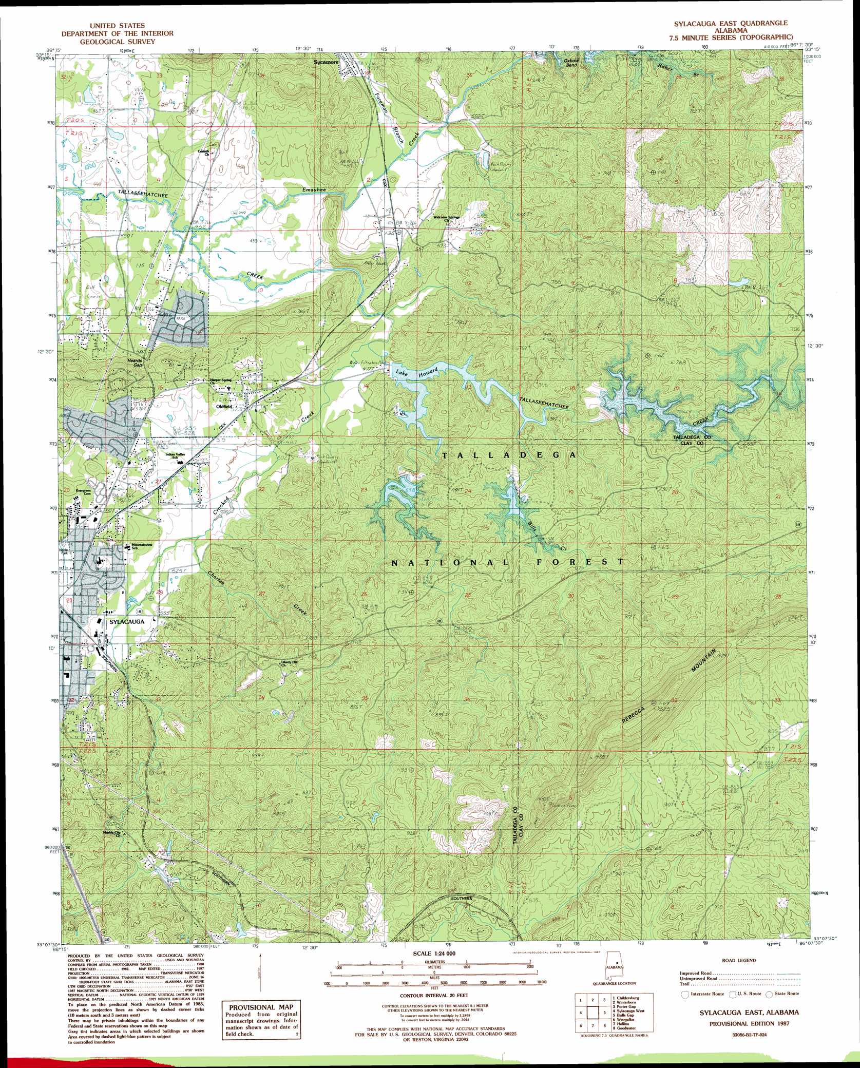
Sylacauga East Topo Map Alabama
To zoom in, hover over the map of Sylacauga East
USGS Topo Quad 33086b2 - 1:24,000 scale
| Topo Map Name: | Sylacauga East |
| USGS Topo Quad ID: | 33086b2 |
| Print Size: | ca. 21 1/4" wide x 27" high |
| Southeast Coordinates: | 33.125° N latitude / 86.125° W longitude |
| Map Center Coordinates: | 33.1875° N latitude / 86.1875° W longitude |
| U.S. State: | AL |
| Filename: | o33086b2.jpg |
| Download Map JPG Image: | Sylacauga East topo map 1:24,000 scale |
| Map Type: | Topographic |
| Topo Series: | 7.5´ |
| Map Scale: | 1:24,000 |
| Source of Map Images: | United States Geological Survey (USGS) |
| Alternate Map Versions: |
Goodwater NW AL 1975, updated 1977 Download PDF Buy paper map Sylacauga East AL 1987, updated 1987 Download PDF Buy paper map Sylacauga East AL 2001, updated 2004 Download PDF Buy paper map Sylacauga East AL 2011 Download PDF Buy paper map Sylacauga East AL 2014 Download PDF Buy paper map |
| FStopo: | US Forest Service topo Sylacauga East is available: Download FStopo PDF Download FStopo TIF |
1:24,000 Topo Quads surrounding Sylacauga East
Vincent |
Laniers |
Sleeping Giants |
Talladega |
Ironaton |
Harpersville |
Childersburg |
Winterboro |
Porter Gap |
Clairmont Springs |
Wilsonville |
Sylacauga West |
Sylacauga East |
Bulls Gap |
Millerville |
Talladega Springs |
Weogufka |
Hollins |
Goodwater |
Hackneyville |
Mitchell Dam Nw |
Flag Mountain |
Rockford |
Kellyton |
Alexander City |
> Back to 33086a1 at 1:100,000 scale
> Back to 33086a1 at 1:250,000 scale
> Back to U.S. Topo Maps home
Sylacauga East topo map: Gazetteer
Sylacauga East: Crossings
Popes Ford elevation 136m 446′Sylacauga East: Dams
Howard Dam elevation 154m 505′Sylacauga East: Gaps
Heards Gap elevation 198m 649′Plank Road Gap elevation 211m 692′
Sylacauga East: Mines
Mesaba Mine elevation 140m 459′Nix Marble Quarry elevation 177m 580′
Sylacauga East: Populated Places
Chico elevation 145m 475′Emauhee elevation 155m 508′
Liberty Hill elevation 226m 741′
Oldfield elevation 170m 557′
Sunrise elevation 188m 616′
The Moon elevation 188m 616′
Sylacauga East: Reservoirs
Lake Howard elevation 154m 505′Sylacauga Reservoir elevation 158m 518′
Tallaseehatchee Creek Watershed N elevation 183m 600′
Tallaseehatchee Creek Watershed N elevation 187m 613′
Tallaseehatchee Watershed Number 1 elevation 164m 538′
Sylacauga East: Ridges
Rebecca Mountain elevation 455m 1492′Sylacauga East: Streams
Bulls Creek elevation 162m 531′Chartee Creek elevation 154m 505′
Crooked Creek elevation 141m 462′
Emauhee Creek elevation 135m 442′
Foreman Branch elevation 145m 475′
London Creek elevation 193m 633′
Paces Branch elevation 142m 465′
Wills Creek elevation 162m 531′
Sylacauga East: Summits
Herds Mountain elevation 227m 744′Sylacauga East digital topo map on disk
Buy this Sylacauga East topo map showing relief, roads, GPS coordinates and other geographical features, as a high-resolution digital map file on DVD: