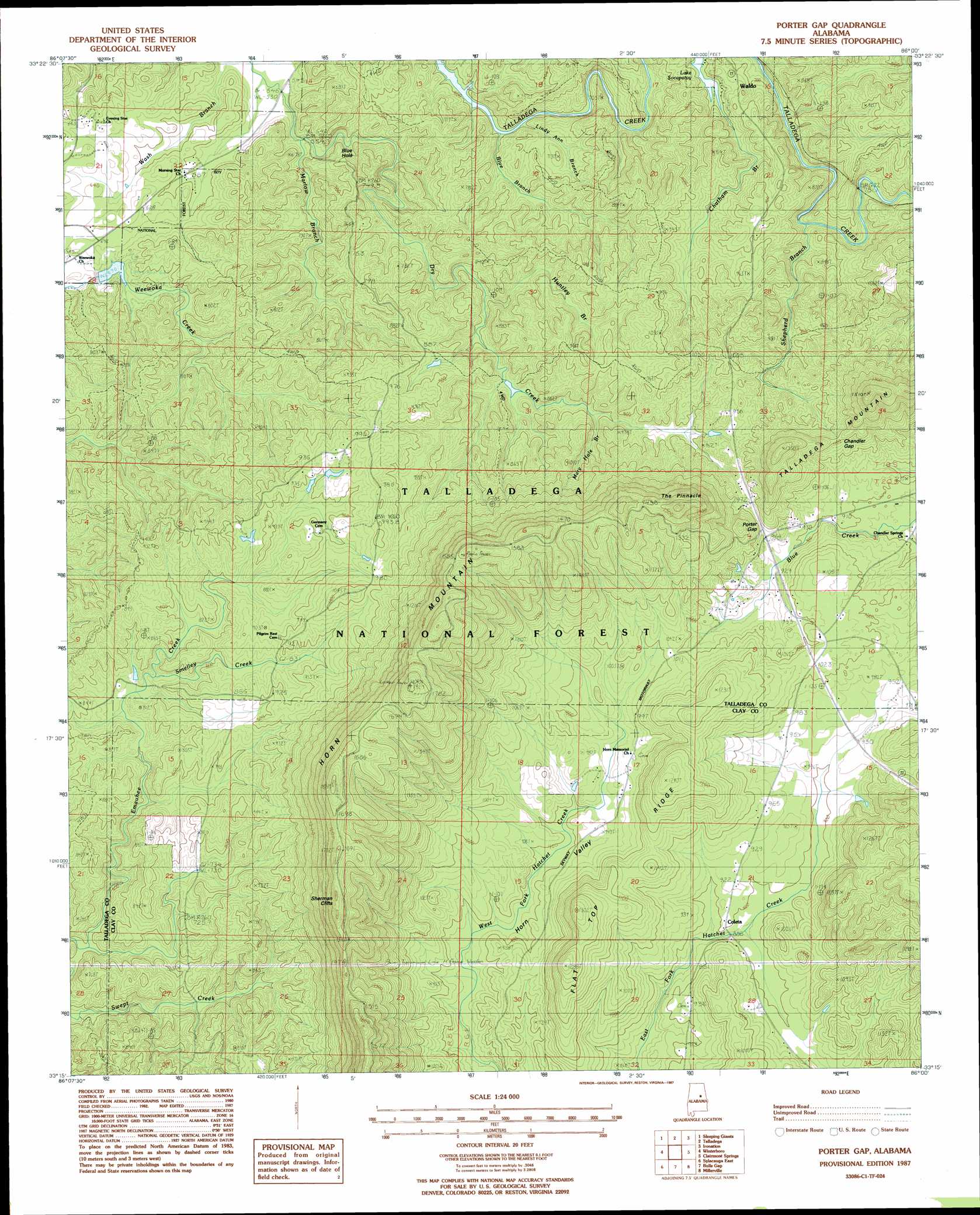
Porter Gap Topo Map Alabama
To zoom in, hover over the map of Porter Gap
USGS Topo Quad 33086c1 - 1:24,000 scale
| Topo Map Name: | Porter Gap |
| USGS Topo Quad ID: | 33086c1 |
| Print Size: | ca. 21 1/4" wide x 27" high |
| Southeast Coordinates: | 33.25° N latitude / 86° W longitude |
| Map Center Coordinates: | 33.3125° N latitude / 86.0625° W longitude |
| U.S. State: | AL |
| Filename: | o33086c1.jpg |
| Download Map JPG Image: | Porter Gap topo map 1:24,000 scale |
| Map Type: | Topographic |
| Topo Series: | 7.5´ |
| Map Scale: | 1:24,000 |
| Source of Map Images: | United States Geological Survey (USGS) |
| Alternate Map Versions: |
Talladega SE AL 1975, updated 1977 Download PDF Buy paper map Porter Gap AL 1987, updated 1987 Download PDF Buy paper map Porter Gap AL 2001, updated 2004 Download PDF Buy paper map Porter Gap AL 2011 Download PDF Buy paper map Porter Gap AL 2014 Download PDF Buy paper map |
| FStopo: | US Forest Service topo Porter Gap is available: Download FStopo PDF Download FStopo TIF |
1:24,000 Topo Quads surrounding Porter Gap
Pell City |
Riverside |
Eastaboga |
Munford |
Oxford |
Laniers |
Sleeping Giants |
Talladega |
Ironaton |
Cheaha Mountain |
Childersburg |
Winterboro |
Porter Gap |
Clairmont Springs |
Lineville West |
Sylacauga West |
Sylacauga East |
Bulls Gap |
Millerville |
Gibsonville |
Weogufka |
Hollins |
Goodwater |
Hackneyville |
New Site |
> Back to 33086a1 at 1:100,000 scale
> Back to 33086a1 at 1:250,000 scale
> Back to U.S. Topo Maps home
Porter Gap topo map: Gazetteer
Porter Gap: Cliffs
Sherman Cliffs elevation 476m 1561′Porter Gap: Dams
Jogloma Dam elevation 220m 721′Porter Gap: Falls
Great Falls elevation 292m 958′Porter Gap: Flats
Penitentiary Bottoms elevation 182m 597′Porter Gap: Gaps
Chandler Gap elevation 337m 1105′Porter Gap elevation 308m 1010′
Porter Gap: Lakes
Blue Hole elevation 171m 561′Porter Gap: Mines
Hatchet Creek Prospect elevation 280m 918′Porter Gap: Populated Places
Chambers Springs elevation 294m 964′Coleta elevation 274m 898′
Smelley elevation 295m 967′
Taylors Mill elevation 377m 1236′
Porter Gap: Post Offices
Oto Post Office (historical) elevation 312m 1023′Pennington Post Office (historical) elevation 171m 561′
Smelley Post Office elevation 295m 967′
Porter Gap: Reservoirs
Jogloma Lake elevation 226m 741′Monk Creek Reservoir elevation 258m 846′
Pinnacle Lake elevation 278m 912′
Tallaseehatchee Watershed Number Six Lake elevation 194m 636′
Porter Gap: Ridges
Flat Top Ridge elevation 338m 1108′Porter Gap: Streams
Blue Branch elevation 180m 590′Dry Creek elevation 162m 531′
Huntley Branch elevation 221m 725′
Lundy Ann Branch elevation 197m 646′
Marlow Branch elevation 171m 561′
Mary Hole Branch elevation 235m 770′
Shepherd Branch elevation 218m 715′
Smelley Creek elevation 227m 744′
Tyler Branch elevation 208m 682′
Porter Gap: Summits
Horn Mountain elevation 588m 1929′The Pinnacle elevation 489m 1604′
Porter Gap: Valleys
Horn Valley elevation 288m 944′Horns Valley elevation 266m 872′
Porter Gap digital topo map on disk
Buy this Porter Gap topo map showing relief, roads, GPS coordinates and other geographical features, as a high-resolution digital map file on DVD: