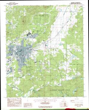
Talladega Topo Map Alabama
To zoom in, hover over the map of Talladega
USGS Topo Quad 33086d1 - 1:24,000 scale
| Topo Map Name: | Talladega |
| USGS Topo Quad ID: | 33086d1 |
| Print Size: | ca. 21 1/4" wide x 27" high |
| Southeast Coordinates: | 33.375° N latitude / 86° W longitude |
| Map Center Coordinates: | 33.4375° N latitude / 86.0625° W longitude |
| U.S. State: | AL |
| Filename: | o33086d1.jpg |
| Download Map JPG Image: | Talladega topo map 1:24,000 scale |
| Map Type: | Topographic |
| Topo Series: | 7.5´ |
| Map Scale: | 1:24,000 |
| Source of Map Images: | United States Geological Survey (USGS) |
| Alternate Map Versions: |
Talladega NE AL 1975, updated 1977 Download PDF Buy paper map Talladega AL 1987, updated 1987 Download PDF Buy paper map Talladega AL 2001, updated 2004 Download PDF Buy paper map Talladega AL 2011 Download PDF Buy paper map Talladega AL 2014 Download PDF Buy paper map |
| FStopo: | US Forest Service topo Talladega is available: Download FStopo PDF Download FStopo TIF |
1:24,000 Topo Quads surrounding Talladega
> Back to 33086a1 at 1:100,000 scale
> Back to 33086a1 at 1:250,000 scale
> Back to U.S. Topo Maps home
Talladega topo map: Gazetteer
Talladega: Bridges
Waldo Covered Bridge elevation 194m 636′Talladega: Dams
Cheaha Creek Watershed Dam Number 2 elevation 187m 613′Cheaha Creek Watershed Dam Number 3 elevation 201m 659′
Elliott Lake Dam elevation 172m 564′
Lake Socapatoy Dam elevation 236m 774′
Mary Lake Dam elevation 215m 705′
Mump Creek Reservoir Dam elevation 217m 711′
Talladega Lake Dam elevation 215m 705′
Talladega: Flats
Moberley Bottom elevation 159m 521′Talladega: Lakes
Pond Springs elevation 173m 567′Sugar Pond elevation 189m 620′
Talladega: Mines
Gold Log Mine elevation 205m 672′Talladega: Parks
Bingham Park elevation 195m 639′Jemison Park elevation 183m 600′
Mary Dumas Stadium elevation 185m 606′
McMillan Park elevation 182m 597′
Pines Park elevation 169m 554′
Silk Stocking Historic District elevation 183m 600′
Talladega College Historic District elevation 178m 583′
Talladega Courthouse Square Historic District elevation 172m 564′
Talladega: Populated Places
Allison Mills elevation 152m 498′Bemiston elevation 171m 561′
Brecon elevation 186m 610′
Carara elevation 212m 695′
Curry elevation 164m 538′
Jonesville elevation 176m 577′
McCannsville elevation 190m 623′
Moorefield elevation 187m 613′
Mount Olive Circle elevation 218m 715′
Pulliamville elevation 178m 583′
Stockdale elevation 189m 620′
Talladega elevation 170m 557′
Waldo elevation 215m 705′
Talladega: Post Offices
Bledsoe Post Office (historical) elevation 187m 613′Chinnabee Post Office (historical) elevation 183m 600′
Maria Forge Post Office (historical) elevation 191m 626′
Talladega: Reservoirs
Elliott Lake elevation 172m 564′Hanes Cheaha Lake elevation 201m 659′
Lake Joan elevation 201m 659′
Lake Socapatoy elevation 209m 685′
Lake Socapatoy elevation 236m 774′
Mump Creek Reservoir elevation 217m 711′
Spring Lake elevation 168m 551′
Talladega Lake elevation 215m 705′
Whites Cheaha Lake elevation 187m 613′
Talladega: Springs
Big Spring elevation 166m 544′Isbell Spring elevation 161m 528′
Talladega: Streams
Chatham Branch elevation 192m 629′Drivers Branch elevation 165m 541′
Dry Creek elevation 172m 564′
Mump Creek elevation 193m 633′
Pond Springs Branch elevation 166m 544′
Rock Run elevation 171m 561′
Wash Branch elevation 189m 620′
Weisingel Branch elevation 150m 492′
Talladega: Summits
Bald Mountain elevation 291m 954′College Hill elevation 177m 580′
Gents Mountain elevation 257m 843′
Londons Hill elevation 262m 859′
Nances Hill elevation 203m 666′
Sand Mountain elevation 227m 744′
Talladega digital topo map on disk
Buy this Talladega topo map showing relief, roads, GPS coordinates and other geographical features, as a high-resolution digital map file on DVD:


