Vincent Topo Map Alabama
To zoom in, hover over the map of Vincent
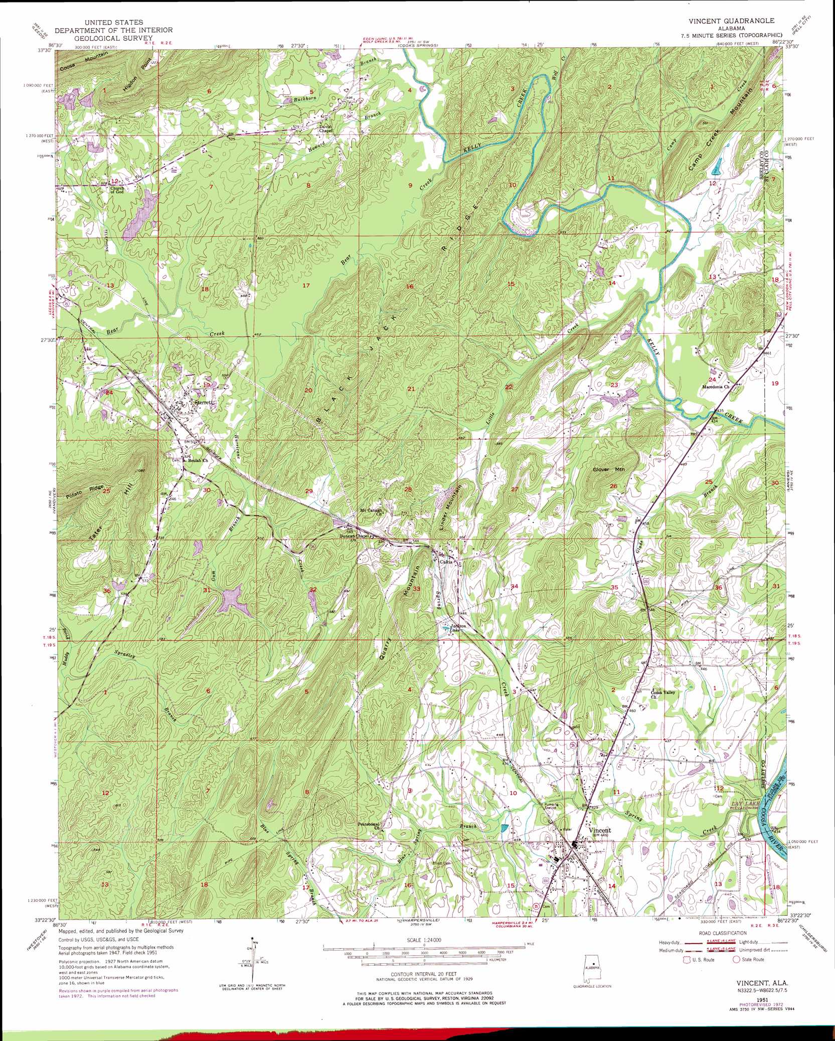
USGS Topo Quad 33086d4 - 1:24,000 scale
| Topo Map Name: | Vincent |
| USGS Topo Quad ID: | 33086d4 |
| Print Size: | ca. 21 1/4" wide x 27" high |
| Southeast Coordinates: | 33.375° N latitude / 86.375° W longitude |
| Map Center Coordinates: | 33.4375° N latitude / 86.4375° W longitude |
| U.S. State: | AL |
| Filename: | o33086d4.jpg |
| Download Map JPG Image: | Vincent topo map 1:24,000 scale |
| Map Type: | Topographic |
| Topo Series: | 7.5´ |
| Map Scale: | 1:24,000 |
| Source of Map Images: | United States Geological Survey (USGS) |
| Alternate Map Versions: |
Vincent AL 1951, updated 1952 Download PDF Buy paper map Vincent AL 1951, updated 1969 Download PDF Buy paper map Vincent AL 1951, updated 1973 Download PDF Buy paper map Vincent AL 1951, updated 1977 Download PDF Buy paper map Vincent AL 1951, updated 1977 Download PDF Buy paper map Vincent AL 1975, updated 1977 Download PDF Buy paper map Vincent AL 2011 Download PDF Buy paper map Vincent AL 2014 Download PDF Buy paper map |
1:24,000 Topo Quads surrounding Vincent
Pinson |
Argo |
Odenville |
Wattsville |
Ragland |
Irondale |
Leeds |
Cooks Springs |
Pell City |
Riverside |
Cahaba Heights |
Vandiver |
Vincent |
Laniers |
Sleeping Giants |
Chelsea |
Westover |
Harpersville |
Childersburg |
Winterboro |
Bounds Lake |
Columbiana |
Wilsonville |
Sylacauga West |
Sylacauga East |
> Back to 33086a1 at 1:100,000 scale
> Back to 33086a1 at 1:250,000 scale
> Back to U.S. Topo Maps home
Vincent topo map: Gazetteer
Vincent: Capes
Higdon Point elevation 272m 892′Vincent: Crossings
Glovers Ferry (historical) elevation 119m 390′Vincent: Dams
Acton Lake Dam elevation 172m 564′Coosa Lodge Lake Dam elevation 145m 475′
Crim Lake Dam elevation 166m 544′
Hall Dam elevation 163m 534′
Ledbetter Lake Dam Number 1 elevation 219m 718′
Ledbetter Lake Dam Number 2 elevation 187m 613′
Vincent: Lakes
Jackson Lake elevation 146m 479′Vincent: Parks
Glovers Point Park elevation 124m 406′Vincent: Populated Places
Calcis elevation 163m 534′Cloverdale elevation 136m 446′
Sterrett elevation 158m 518′
Vincent elevation 138m 452′
Vincent: Post Offices
Sterrett Post Office elevation 159m 521′Vincent Post Office elevation 136m 446′
Vincent: Reservoirs
Acton Lake elevation 172m 564′Baggetts Lake elevation 145m 475′
Hall Lake elevation 163m 534′
Lake Dewitt elevation 166m 544′
Ledbetter Lake elevation 219m 718′
Ledbetter Lake Number 2 elevation 187m 613′
Martin Town Lake elevation 134m 439′
Vincent: Ridges
Black Jack Ridge elevation 219m 718′Vincent: Streams
Bear Creek elevation 135m 442′Blue Spring Branch elevation 131m 429′
Buckhorn Branch elevation 134m 439′
Camp Creek elevation 125m 410′
Glade Branch elevation 127m 416′
Gum Branch elevation 143m 469′
Howard Branch elevation 134m 439′
Hurricane Creek elevation 138m 452′
Little Creek elevation 128m 419′
Spradley Branch elevation 150m 492′
Spring Creek elevation 121m 396′
Wolf Creek elevation 135m 442′
Yellow Branch elevation 144m 472′
Vincent: Summits
Glover Mountain elevation 171m 561′Linder Mountain elevation 195m 639′
Quarry Mountain elevation 207m 679′
Tater Hill elevation 325m 1066′
Vincent digital topo map on disk
Buy this Vincent topo map showing relief, roads, GPS coordinates and other geographical features, as a high-resolution digital map file on DVD: