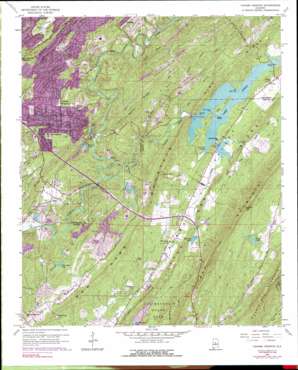
Cahaba Heights Topo Map Alabama
To zoom in, hover over the map of Cahaba Heights
USGS Topo Quad 33086d6 - 1:24,000 scale
| Topo Map Name: | Cahaba Heights |
| USGS Topo Quad ID: | 33086d6 |
| Print Size: | ca. 21 1/4" wide x 27" high |
| Southeast Coordinates: | 33.375° N latitude / 86.625° W longitude |
| Map Center Coordinates: | 33.4375° N latitude / 86.6875° W longitude |
| U.S. State: | AL |
| Filename: | o33086d6.jpg |
| Download Map JPG Image: | Cahaba Heights topo map 1:24,000 scale |
| Map Type: | Topographic |
| Topo Series: | 7.5´ |
| Map Scale: | 1:24,000 |
| Source of Map Images: | United States Geological Survey (USGS) |
| Alternate Map Versions: |
Cahaba Heights AL 1959, updated 1960 Download PDF Buy paper map Cahaba Heights AL 1959, updated 1960 Download PDF Buy paper map Cahaba Heights AL 1959, updated 1971 Download PDF Buy paper map Cahaba Heights AL 1959, updated 1978 Download PDF Buy paper map Cahaba Heights AL 1959, updated 1991 Download PDF Buy paper map Cahaba Heights AL 1975, updated 1977 Download PDF Buy paper map Cahaba Heights AL 1998, updated 2001 Download PDF Buy paper map Cahaba Heights AL 2011 Download PDF Buy paper map Cahaba Heights AL 2014 Download PDF Buy paper map |
1:24,000 Topo Quads surrounding Cahaba Heights
> Back to 33086a1 at 1:100,000 scale
> Back to 33086a1 at 1:250,000 scale
> Back to U.S. Topo Maps home
Cahaba Heights topo map: Gazetteer
Cahaba Heights: Bridges
Cox Creek Bridge elevation 168m 551′Irondale Bridge elevation 168m 551′
Old Iron Bridge elevation 133m 436′
Cahaba Heights: Capes
Cox Creek Point elevation 168m 551′Hooker Point elevation 168m 551′
Cahaba Heights: Channels
The Narrows elevation 168m 551′Cahaba Heights: Crossings
De Shazoo Mill Ford elevation 168m 551′Dodd Ford elevation 140m 459′
Poole Ford elevation 140m 459′
Cahaba Heights: Dams
Acton Lake Dam elevation 132m 433′Fletcher Properties Lake Dam elevation 139m 456′
Fowler Lake Dam elevation 244m 800′
Lake Dixie Dam elevation 143m 469′
Lake Purdy Dam elevation 152m 498′
McDavid Lake Dam elevation 190m 623′
Moon Glow Lake Dam elevation 149m 488′
Oak Mountain Lake Dam Number Two elevation 167m 547′
Cahaba Heights: Gaps
Bailey Gap elevation 201m 659′Bailey Gap elevation 218m 715′
Brasier Gap elevation 297m 974′
Looney Gap elevation 237m 777′
Overton Gap elevation 332m 1089′
Cahaba Heights: Guts
Ike Pond Slough elevation 168m 551′Cahaba Heights: Islands
Goat Island elevation 172m 564′Little Island elevation 168m 551′
Cahaba Heights: Lakes
Blue Pond elevation 182m 597′Fowler Lake elevation 247m 810′
Cahaba Heights: Mines
Ballard Mine elevation 144m 472′Clark Mine elevation 211m 692′
Duke Mine elevation 152m 498′
Overton Mine elevation 179m 587′
Overton Number 1 Slope Mine elevation 176m 577′
Pump Station Mine elevation 177m 580′
Roberts Wagon Mine elevation 187m 613′
Thompson Mine elevation 174m 570′
Cahaba Heights: Parks
Spain Park elevation 153m 501′Cahaba Heights: Populated Places
Acton elevation 148m 485′Altadena Ridge Estates elevation 205m 672′
Altadena Woods elevation 175m 574′
Asbury Park elevation 196m 643′
Bridgeton elevation 171m 561′
Brook Highland elevation 182m 597′
Cahaba Cliffs elevation 153m 501′
Cahaba Commons elevation 138m 452′
Cahaba Heights elevation 196m 643′
Cahaba Oaks elevation 221m 725′
Camp Horne elevation 181m 593′
Dunbarton Oaks elevation 208m 682′
Heritage Oaks elevation 179m 587′
Hickory Ridge elevation 196m 643′
Homestead elevation 154m 505′
Inverness elevation 150m 492′
Inverness Cliffs elevation 177m 580′
Inverness Point elevation 134m 439′
Lake Purdy elevation 202m 662′
Little Ridge Estates elevation 185m 606′
Meadow Ridge elevation 169m 554′
Meadowbrook elevation 191m 626′
Morning Sun Villas elevation 236m 774′
Overton Manor elevation 214m 702′
Riverwood elevation 165m 541′
Shoal Run elevation 185m 606′
Sunnymeadows elevation 172m 564′
Wellington Park elevation 201m 659′
Westbrook Trace elevation 159m 521′
Woodford elevation 177m 580′
Cahaba Heights: Reservoirs
Altadena Lake elevation 132m 433′Elmore Lake elevation 143m 469′
Fletcher Estate Lake elevation 139m 456′
Heather Lake elevation 143m 469′
Lake Dixie elevation 143m 469′
Lake Helen elevation 144m 472′
Lake Purdy elevation 164m 538′
Lunker Lake elevation 173m 567′
McDavid Lake elevation 192m 629′
Moon Glow Lake elevation 156m 511′
Cahaba Heights: Ridges
Little Oak Ridge elevation 219m 718′New Hope Mountain elevation 216m 708′
Oak Mountain elevation 336m 1102′
Rocky Ridge elevation 181m 593′
Cahaba Heights: Streams
Big Branch elevation 147m 482′Coal Branch elevation 138m 452′
Fleming Branch elevation 132m 433′
Fuller Creek elevation 141m 462′
Gumsuck Branch elevation 140m 459′
Jeb Branch elevation 182m 597′
Lee Branch elevation 168m 551′
Little Cahaba River elevation 130m 426′
North Prong Cox Creek elevation 171m 561′
South Prong Cox Creek elevation 171m 561′
Cahaba Heights digital topo map on disk
Buy this Cahaba Heights topo map showing relief, roads, GPS coordinates and other geographical features, as a high-resolution digital map file on DVD:


