Birmingham North Topo Map Alabama
To zoom in, hover over the map of Birmingham North
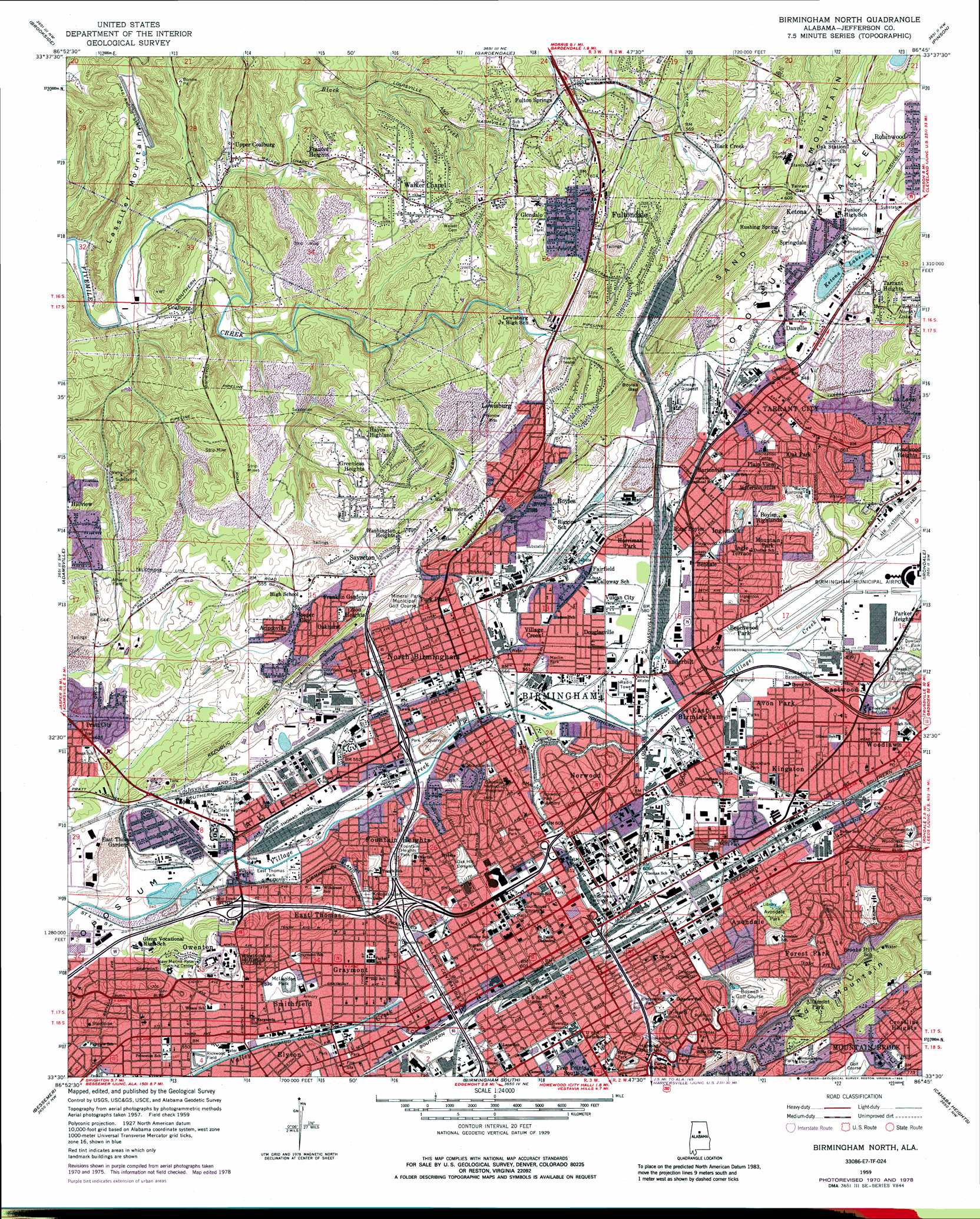
USGS Topo Quad 33086e7 - 1:24,000 scale
| Topo Map Name: | Birmingham North |
| USGS Topo Quad ID: | 33086e7 |
| Print Size: | ca. 21 1/4" wide x 27" high |
| Southeast Coordinates: | 33.5° N latitude / 86.75° W longitude |
| Map Center Coordinates: | 33.5625° N latitude / 86.8125° W longitude |
| U.S. State: | AL |
| Filename: | o33086e7.jpg |
| Download Map JPG Image: | Birmingham North topo map 1:24,000 scale |
| Map Type: | Topographic |
| Topo Series: | 7.5´ |
| Map Scale: | 1:24,000 |
| Source of Map Images: | United States Geological Survey (USGS) |
| Alternate Map Versions: |
Birmingham North AL 1959, updated 1961 Download PDF Buy paper map Birmingham North AL 1959, updated 1961 Download PDF Buy paper map Birmingham North AL 1959, updated 1971 Download PDF Buy paper map Birmingham North AL 1959, updated 1978 Download PDF Buy paper map Birmingham North AL 1959, updated 1978 Download PDF Buy paper map Birmingham North AL 1959, updated 1986 Download PDF Buy paper map Birmingham North AL 1975, updated 1977 Download PDF Buy paper map Birmingham North AL 1997, updated 2001 Download PDF Buy paper map Birmingham North AL 2011 Download PDF Buy paper map Birmingham North AL 2014 Download PDF Buy paper map |
1:24,000 Topo Quads surrounding Birmingham North
Sipsey |
Creel |
Warrior |
Trafford |
Remlap |
Dora |
Brookside |
Gardendale |
Pinson |
Argo |
Sylvan Springs |
Adamsville |
Birmingham North |
Irondale |
Leeds |
Concord |
Bessemer |
Birmingham South |
Cahaba Heights |
Vandiver |
Mccalla |
Greenwood |
Helena |
Chelsea |
Westover |
> Back to 33086e1 at 1:100,000 scale
> Back to 33086a1 at 1:250,000 scale
> Back to U.S. Topo Maps home
Birmingham North topo map: Gazetteer
Birmingham North: Airports
Birmingham Municipal Airport elevation 187m 613′Number One Fire Station Airport elevation 183m 600′
Perry Airport elevation 178m 583′
Powell Avenue Airport elevation 196m 643′
Riviera Airport elevation 206m 675′
Birmingham North: Crossings
Interchange 123 elevation 174m 570′Interchange 124 elevation 189m 620′
Interchange 125A elevation 183m 600′
Interchange 125B elevation 182m 597′
Interchange 126A elevation 184m 603′
Interchange 126B elevation 197m 646′
Interchange 128 elevation 177m 580′
Interchange 129 elevation 189m 620′
Interchange 259B elevation 183m 600′
Interchange 260 elevation 176m 577′
Interchange 261 elevation 190m 623′
Interchange 262A elevation 182m 597′
Interchange 262B elevation 167m 547′
Interchange 263 elevation 185m 606′
Interchange 266 elevation 181m 593′
Interchange 267 elevation 193m 633′
Birmingham North: Dams
Boyles Gap Lake Dam elevation 158m 518′East Thomas Gardens Dam elevation 166m 544′
Rock Mountain Lake Dam elevation 200m 656′
Birmingham North: Gaps
Boyles Gap elevation 159m 521′Tarrant Gap elevation 188m 616′
Birmingham North: Lakes
Ketona Lakes elevation 162m 531′Birmingham North: Mines
Arcadia Mine elevation 157m 515′Bailey Mine elevation 207m 679′
Big Ten Mine elevation 176m 577′
Daisy City Mine elevation 161m 528′
Dolcito Quarry elevation 182m 597′
Graves Mines elevation 186m 610′
Hamilton Mine elevation 165m 541′
Ketona Quarry (historical) elevation 170m 557′
Lewisburg Mine elevation 159m 521′
Lewisburg Mine elevation 197m 646′
Mary Lee Mines elevation 164m 538′
McConnell Mine elevation 183m 600′
Morrow Mines elevation 187m 613′
Pit Twenty Mine elevation 141m 462′
Rosebud Mine elevation 161m 528′
Sayreton Number 2 Mine elevation 157m 515′
Sloss Quarry elevation 127m 416′
Snake Mine elevation 207m 679′
Spencer Quarry elevation 181m 593′
Birmingham North: Parks
Altamont Park elevation 274m 898′Automotive Historic District elevation 187m 613′
Avondale Mills Park elevation 185m 606′
Avondale Park elevation 213m 698′
Barker Park elevation 200m 656′
Beachwood Park elevation 182m 597′
Caldwell Park elevation 219m 718′
Chestnut Hill Historic District elevation 231m 757′
Clayton Park elevation 198m 649′
Downtown Birmingham Historic District elevation 188m 616′
Downtown Birmingham Retail and Theatre Historic District elevation 182m 597′
Duke Park elevation 165m 541′
East Thomas Park elevation 165m 541′
Fountain Heights Park elevation 193m 633′
Fourth Avenue Historic District elevation 181m 593′
Hanover Park elevation 230m 754′
Highland Avenue Historic District elevation 228m 748′
Inglenook Park elevation 198m 649′
Ingram Park elevation 183m 600′
Joseph Riley Smith Historic District elevation 193m 633′
Lakeview Park (historical) elevation 214m 702′
Lassiter Mountain Raceway Park elevation 214m 702′
Legion Field elevation 172m 564′
Maclin Park elevation 171m 561′
Magnolia Park elevation 203m 666′
Marconi Park elevation 186m 610′
McLendon Park elevation 174m 570′
Morris Avenue-First Avenue North Historic District elevation 189m 620′
North Birmingham Park elevation 182m 597′
Norwood Park elevation 188m 616′
Red Mountain Suburbs Historic District elevation 287m 941′
Rhodes Park elevation 221m 725′
Rickwood Field elevation 166m 544′
Rushton Park elevation 215m 705′
Sloss Furnaces National Historic Landmark elevation 190m 623′
Smithfield Historic District elevation 173m 567′
Smiths Park (historical) elevation 174m 570′
Stockham Park elevation 183m 600′
Thomas Historic District elevation 170m 557′
Underwood Park elevation 203m 666′
Willowwood Park elevation 189m 620′
Woodcrest Park elevation 220m 721′
Woodlawn Commercial Historic District elevation 194m 636′
Woodrow Wilson Park elevation 184m 603′
Birmingham North: Populated Places
Acipcoville elevation 186m 610′Altamont Park elevation 293m 961′
Avon Park elevation 181m 593′
Avondale elevation 196m 643′
Bartonville elevation 171m 561′
Bendale elevation 186m 610′
Birmingham elevation 187m 613′
Black Creek elevation 175m 574′
Boyles Highlands elevation 222m 728′
Coalburg elevation 143m 469′
Crestline Heights elevation 225m 738′
Danville elevation 168m 551′
Douglasville elevation 174m 570′
East Birmingham elevation 177m 580′
East Boyles elevation 172m 564′
East Thomas elevation 212m 695′
East Thomas Gardens elevation 170m 557′
Eastwood elevation 183m 600′
Elyton elevation 174m 570′
Fairfield elevation 177m 580′
Five Points South elevation 201m 659′
Forest Park elevation 243m 797′
Fountain Heights elevation 176m 577′
Frances Heights elevation 176m 577′
Franklin Gardens elevation 196m 643′
Fulton Springs elevation 152m 498′
Fultondale elevation 186m 610′
Fultondale Estates elevation 203m 666′
Glendale elevation 184m 603′
Graymont elevation 175m 574′
Graysons Addition elevation 179m 587′
Greenleas Heights elevation 222m 728′
Harriman Park elevation 176m 577′
Hayes Highland elevation 201m 659′
Highland Residence Park elevation 226m 741′
Hooper City elevation 182m 597′
Humoro elevation 196m 643′
Ingle Terrace elevation 211m 692′
Inglenook elevation 184m 603′
Jefferson Hills elevation 198m 649′
Ketona elevation 183m 600′
Kingston elevation 190m 623′
Lewisburg elevation 183m 600′
Magnolia Heights elevation 206m 675′
Meadwood Heights elevation 205m 672′
Mountain Brook elevation 234m 767′
Mountain Park elevation 200m 656′
North Birmingham elevation 177m 580′
Norwood elevation 198m 649′
Oak Forest elevation 200m 656′
Oak Lawn elevation 214m 702′
Oak Park elevation 194m 636′
Oakhurst elevation 191m 626′
Owenton elevation 204m 669′
Park Place elevation 186m 610′
Parker Heights elevation 188m 616′
Plain View elevation 176m 577′
Pratt City elevation 185m 606′
Redmont Park elevation 296m 971′
Sayreton elevation 201m 659′
Smithfield elevation 170m 557′
Spring Garden elevation 189m 620′
Springdale elevation 175m 574′
Tarrant elevation 166m 544′
Tarrant Garden Estates elevation 219m 718′
Tarrant Heights elevation 186m 610′
Thomas elevation 171m 561′
Upper Coalburg elevation 135m 442′
Vanderbilt elevation 177m 580′
Village Creek elevation 173m 567′
Vulcan City elevation 174m 570′
Walker Chapel elevation 207m 679′
Washington Heights elevation 209m 685′
Woodlawn elevation 195m 639′
Zion Heights elevation 194m 636′
Birmingham North: Post Offices
Birmingham Post Office elevation 183m 600′Birmingham North: Reservoirs
Boyles Gap Lake elevation 158m 518′East Thomas Gardens Lake elevation 166m 544′
Pawnee Reservoir elevation 200m 656′
Birmingham North: Ridges
Enon Ridge elevation 190m 623′Red Mountain elevation 315m 1033′
Birmingham North: Streams
Black Creek elevation 126m 413′Birmingham North: Summits
Lassiter Mountain elevation 202m 662′Birmingham North digital topo map on disk
Buy this Birmingham North topo map showing relief, roads, GPS coordinates and other geographical features, as a high-resolution digital map file on DVD: