Ohatchee Topo Map Alabama
To zoom in, hover over the map of Ohatchee
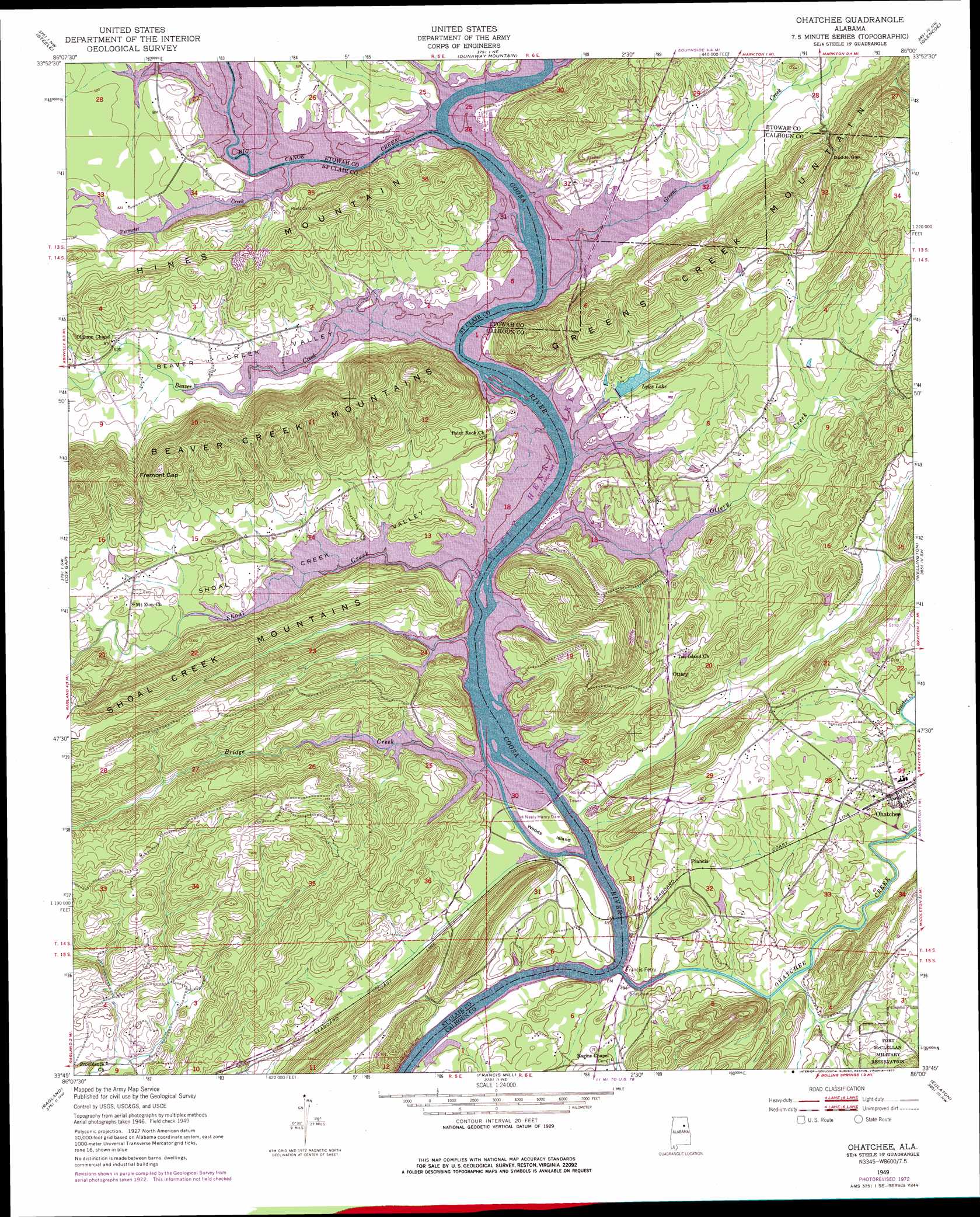
USGS Topo Quad 33086g1 - 1:24,000 scale
| Topo Map Name: | Ohatchee |
| USGS Topo Quad ID: | 33086g1 |
| Print Size: | ca. 21 1/4" wide x 27" high |
| Southeast Coordinates: | 33.75° N latitude / 86° W longitude |
| Map Center Coordinates: | 33.8125° N latitude / 86.0625° W longitude |
| U.S. State: | AL |
| Filename: | o33086g1.jpg |
| Download Map JPG Image: | Ohatchee topo map 1:24,000 scale |
| Map Type: | Topographic |
| Topo Series: | 7.5´ |
| Map Scale: | 1:24,000 |
| Source of Map Images: | United States Geological Survey (USGS) |
| Alternate Map Versions: |
Ohatchee AL 1949, updated 1953 Download PDF Buy paper map Ohatchee AL 1949, updated 1973 Download PDF Buy paper map Ohatchee AL 1949, updated 1977 Download PDF Buy paper map Ohatchee AL 1949, updated 1977 Download PDF Buy paper map Ohatchee AL 1975, updated 1977 Download PDF Buy paper map Ohatchee AL 2012 Download PDF Buy paper map Ohatchee AL 2014 Download PDF Buy paper map |
1:24,000 Topo Quads surrounding Ohatchee
Altoona |
Howelton |
Gadsden West |
Gadsden East |
Ballplay |
Hyatt Gap |
Steele |
Dunaway Mountain |
Glencoe |
Colvin Gap |
Ashville |
Cox Gap |
Ohatchee |
Wellington |
Jacksonville West |
Wattsville |
Ragland |
Francis Mill |
Eulaton |
Anniston |
Pell City |
Riverside |
Eastaboga |
Munford |
Oxford |
> Back to 33086e1 at 1:100,000 scale
> Back to 33086a1 at 1:250,000 scale
> Back to U.S. Topo Maps home
Ohatchee topo map: Gazetteer
Ohatchee: Bars
Leota Shoals elevation 155m 508′Ohatchee: Bends
Riddles Bend elevation 159m 521′Ohatchee: Crossings
Francis Ferry (historical) elevation 142m 465′Greensport Ferry (historical) elevation 155m 508′
Ohatchee: Dams
H Neely Henry Dam elevation 142m 465′Lock Number One (historical) elevation 155m 508′
Lock Number Three (historical) elevation 142m 465′
Lock Number Two (historical) elevation 142m 465′
Lyles Dam elevation 159m 521′
Ohatchee: Gaps
Dodds Gap elevation 219m 718′Fremont Gap elevation 228m 748′
Phillips Gap elevation 181m 593′
Ohatchee: Islands
Ten Islands (historical) elevation 142m 465′Woods Island elevation 142m 465′
Ohatchee: Populated Places
Cochran Springs (historical) elevation 171m 561′Francis elevation 165m 541′
Ohatchee elevation 155m 508′
Otipalin (historical) elevation 142m 465′
Ottery elevation 165m 541′
Ragan Chapel elevation 153m 501′
Ten Islands elevation 177m 580′
Timmons Springs (historical) elevation 159m 521′
Ohatchee: Post Offices
Ten Islands Post Office elevation 177m 580′Ohatchee: Reservoirs
H Neely Henry Lake elevation 142m 465′Lyles Lake elevation 159m 521′
Ohatchee: Ridges
Greens Creek Mountain elevation 233m 764′Ohatchee: Springs
Cochran Springs elevation 176m 577′Green Spring elevation 161m 528′
Ohatchee: Streams
Beaver Creek elevation 155m 508′Big Canoe Creek elevation 155m 508′
Bridge Creek elevation 142m 465′
Greens Creek elevation 155m 508′
Ohatchee Creek elevation 142m 465′
Ottery Creek elevation 142m 465′
Permeter Creek elevation 155m 508′
Shoal Creek elevation 142m 465′
Ohatchee: Summits
Hines Mountain elevation 204m 669′Point Jones elevation 219m 718′
Ohatchee: Valleys
Beaver Creek Valley elevation 155m 508′Green Valley elevation 155m 508′
Shoal Creek Valley elevation 142m 465′
Slash Ham Valley elevation 155m 508′
Ohatchee digital topo map on disk
Buy this Ohatchee topo map showing relief, roads, GPS coordinates and other geographical features, as a high-resolution digital map file on DVD: