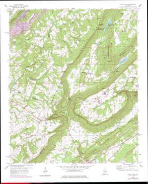
Hyatt Gap Topo Map Alabama
To zoom in, hover over the map of Hyatt Gap
USGS Topo Quad 33086h3 - 1:24,000 scale
| Topo Map Name: | Hyatt Gap |
| USGS Topo Quad ID: | 33086h3 |
| Print Size: | ca. 21 1/4" wide x 27" high |
| Southeast Coordinates: | 33.875° N latitude / 86.25° W longitude |
| Map Center Coordinates: | 33.9375° N latitude / 86.3125° W longitude |
| U.S. State: | AL |
| Filename: | o33086h3.jpg |
| Download Map JPG Image: | Hyatt Gap topo map 1:24,000 scale |
| Map Type: | Topographic |
| Topo Series: | 7.5´ |
| Map Scale: | 1:24,000 |
| Source of Map Images: | United States Geological Survey (USGS) |
| Alternate Map Versions: |
Hyatt Gap AL 1958, updated 1960 Download PDF Buy paper map Hyatt Gap AL 1958, updated 1963 Download PDF Buy paper map Hyatt Gap AL 1958, updated 1976 Download PDF Buy paper map Hyatt Gap AL 1958, updated 1978 Download PDF Buy paper map Hyatt Gap AL 1975, updated 1977 Download PDF Buy paper map Hyatt Gap AL 2011 Download PDF Buy paper map Hyatt Gap AL 2014 Download PDF Buy paper map |
1:24,000 Topo Quads surrounding Hyatt Gap
> Back to 33086e1 at 1:100,000 scale
> Back to 33086a1 at 1:250,000 scale
> Back to U.S. Topo Maps home
Hyatt Gap topo map: Gazetteer
Hyatt Gap: Basins
The Sink elevation 249m 816′Hyatt Gap: Capes
Point Peter elevation 433m 1420′Hyatt Gap: Cliffs
Yellow Bluff elevation 244m 800′Hyatt Gap: Dams
Etowah Conservation Dam elevation 237m 777′Huff Dam elevation 258m 846′
Larry Jenkins Dam elevation 418m 1371′
Reeves Lake Dam elevation 290m 951′
Sumatanga Dam elevation 220m 721′
Wadsworth Lake Dam elevation 361m 1184′
Hyatt Gap: Gaps
Awtreys Gap elevation 398m 1305′Battle Gap elevation 396m 1299′
Garigus Gap elevation 246m 807′
Gilland Gap elevation 386m 1266′
Hathcock Gap elevation 428m 1404′
Hyatt Gap elevation 274m 898′
Hyatt Gap: Populated Places
Bethlehem elevation 247m 810′Chandler Mountain elevation 401m 1315′
Clear Springs (historical) elevation 244m 800′
Ferguson Crossroad elevation 254m 833′
Maudlin (historical) elevation 312m 1023′
Moodys Chapel elevation 279m 915′
Nash (historical) elevation 231m 757′
Nix (historical) elevation 262m 859′
Hyatt Gap: Post Offices
Maudlin Post Office (historical) elevation 312m 1023′Nash Post Office (historical) elevation 231m 757′
Nix Post Office (historical) elevation 262m 859′
Hyatt Gap: Reservoirs
Etowah Conservation Lake elevation 239m 784′Gilland Lake elevation 244m 800′
Lake Sumatanga elevation 227m 744′
Reeves Lake elevation 290m 951′
Vance Payne Lake elevation 418m 1371′
Wadsworth Lake elevation 361m 1184′
Hyatt Gap: Ridges
Blount Mountain elevation 446m 1463′Texas Ridge elevation 271m 889′
Hyatt Gap: Streams
Bunch Creek elevation 266m 872′Byrd Creek elevation 262m 859′
Early Creek elevation 177m 580′
Hurricane Creek elevation 272m 892′
Jake Creek elevation 203m 666′
Little Gulf Branch elevation 216m 708′
Logan Branch elevation 170m 557′
Hyatt Gap: Summits
Bald Hill elevation 295m 967′Buzzard Rock elevation 406m 1332′
Chandler Mountain elevation 452m 1482′
Little Red Mountain elevation 366m 1200′
Raccoon Mountain elevation 383m 1256′
Hyatt Gap: Valleys
Beason Cove elevation 198m 649′Crawfords Cove elevation 187m 613′
The Gulf elevation 216m 708′
Hyatt Gap digital topo map on disk
Buy this Hyatt Gap topo map showing relief, roads, GPS coordinates and other geographical features, as a high-resolution digital map file on DVD:


