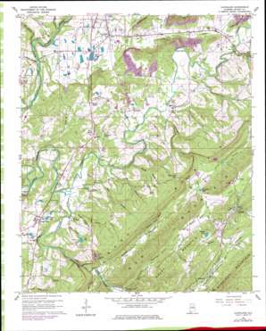
Cleveland Topo Map Alabama
To zoom in, hover over the map of Cleveland
USGS Topo Quad 33086h5 - 1:24,000 scale
| Topo Map Name: | Cleveland |
| USGS Topo Quad ID: | 33086h5 |
| Print Size: | ca. 21 1/4" wide x 27" high |
| Southeast Coordinates: | 33.875° N latitude / 86.5° W longitude |
| Map Center Coordinates: | 33.9375° N latitude / 86.5625° W longitude |
| U.S. State: | AL |
| Filename: | o33086h5.jpg |
| Download Map JPG Image: | Cleveland topo map 1:24,000 scale |
| Map Type: | Topographic |
| Topo Series: | 7.5´ |
| Map Scale: | 1:24,000 |
| Source of Map Images: | United States Geological Survey (USGS) |
| Alternate Map Versions: |
Cleveland AL 1958, updated 1961 Download PDF Buy paper map Cleveland AL 1958, updated 1976 Download PDF Buy paper map Cleveland AL 1958, updated 1978 Download PDF Buy paper map Cleveland AL 1975, updated 1977 Download PDF Buy paper map Cleveland AL 2011 Download PDF Buy paper map Cleveland AL 2014 Download PDF Buy paper map |
1:24,000 Topo Quads surrounding Cleveland
> Back to 33086e1 at 1:100,000 scale
> Back to 33086a1 at 1:250,000 scale
> Back to U.S. Topo Maps home
Cleveland topo map: Gazetteer
Cleveland: Bends
Bains Bend elevation 169m 554′Hair Bend elevation 151m 495′
Horseshoe Bend elevation 134m 439′
Cleveland: Bridges
Moss Bridge elevation 140m 459′Old Easley Road Bridge elevation 200m 656′
Swann Covered Bridge elevation 142m 465′
Cleveland: Cliffs
Pine Bluff elevation 147m 482′Scirum Bluff elevation 178m 583′
Cleveland: Crossings
County Ford elevation 159m 521′Fauss Ford elevation 188m 616′
Martin Ford elevation 131m 429′
Cleveland: Dams
C H Head Lake Dam elevation 158m 518′Doctor Pattons Lake Dam elevation 244m 800′
Gordons Dam elevation 157m 515′
Hazerig Lake Dam elevation 155m 508′
Hazerig Lower Pond Dam elevation 175m 574′
Hazerig Small Pond Dam elevation 153m 501′
Hazerig Upper Pond Dam elevation 158m 518′
Paul Marsh Dam elevation 161m 528′
Tidwell Lake Dam elevation 170m 557′
Tom Robinette Dam elevation 184m 603′
Wilder Lake Dam elevation 184m 603′
Cleveland: Gaps
Crump Gap elevation 209m 685′Hendrick Gap elevation 168m 551′
Sand Mountain Gap elevation 281m 921′
Cleveland: Lakes
Gilliand Pond elevation 172m 564′Tidwell Pond elevation 255m 836′
Cleveland: Populated Places
Allgood elevation 239m 784′Armstead elevation 206m 675′
Balle Mobile Home Park elevation 241m 790′
Blow Gourd elevation 183m 600′
Cleveland elevation 160m 524′
Deavers Town elevation 145m 475′
Easley elevation 178m 583′
Fairview elevation 166m 544′
Graystone elevation 234m 767′
Hendrick Mill elevation 172m 564′
Little Warrior elevation 144m 472′
Locust Fork elevation 178m 583′
Rosa elevation 189m 620′
Cleveland: Post Offices
Allgood Post Office elevation 238m 780′Cleveland Post Office elevation 167m 547′
Warrior Post Office (historical) elevation 157m 515′
Cleveland: Reservoirs
Blackwood Ponds elevation 153m 501′Doctor Pattons Upper Lake elevation 244m 800′
Hazerig Farm Lake elevation 158m 518′
Hazerig Lake elevation 155m 508′
Hazerig Pond elevation 175m 574′
Hazerig Small Pond elevation 153m 501′
Hazerig Upper Pond elevation 158m 518′
Jay Lake elevation 184m 603′
Marsh Lake elevation 161m 528′
Summers Lake elevation 224m 734′
Tidwell Lake elevation 159m 521′
Tom Robinette Lake elevation 184m 603′
Whitmire Ponds elevation 176m 577′
Wilder Lake elevation 172m 564′
Cleveland: Ridges
Peach Orchard Ridge elevation 244m 800′Cleveland: Streams
Andy Branch elevation 158m 518′Big Branch elevation 142m 465′
Big Scirum Creek elevation 132m 433′
Blackburn Fork Little Warrior River elevation 142m 465′
Brice Creek elevation 128m 419′
Calvert Prong Little Warrior River elevation 132m 433′
Causey Branch elevation 165m 541′
Cheney Branch elevation 216m 708′
Chitwood Creek elevation 165m 541′
Clear Branch elevation 222m 728′
Crump Branch elevation 163m 534′
Deavers Branch elevation 137m 449′
Dry Creek elevation 138m 452′
Dry Creek elevation 149m 488′
Floyd Creek elevation 221m 725′
Henderson Creek elevation 123m 403′
Hendrick Branch elevation 218m 715′
Hendrick Mill Branch elevation 172m 564′
Limestone Spring Branch elevation 199m 652′
Little Scirum Creek elevation 138m 452′
Marsh Branch elevation 141m 462′
McCay Branch elevation 139m 456′
Mill Creek elevation 164m 538′
Moore Branch elevation 140m 459′
Moss Branch elevation 134m 439′
Murckle Branch elevation 146m 479′
Murphree Branch elevation 222m 728′
Rulford Branch elevation 147m 482′
Sand Valley Creek elevation 156m 511′
Sapsucker Branch elevation 132m 433′
Tally Branch elevation 140m 459′
Whited Creek elevation 183m 600′
Cleveland: Summits
Browns Mountain elevation 225m 738′Cave Hill elevation 275m 902′
Chert Mountain elevation 352m 1154′
Cornelius Mountain elevation 296m 971′
Hunt Mountain elevation 259m 849′
Cleveland: Valleys
Ingham Valley elevation 157m 515′Lower Sand Valley elevation 222m 728′
Tidwell Hollow elevation 172m 564′
Cleveland digital topo map on disk
Buy this Cleveland topo map showing relief, roads, GPS coordinates and other geographical features, as a high-resolution digital map file on DVD:


