Halfmile Shoals Topo Map Alabama
To zoom in, hover over the map of Halfmile Shoals
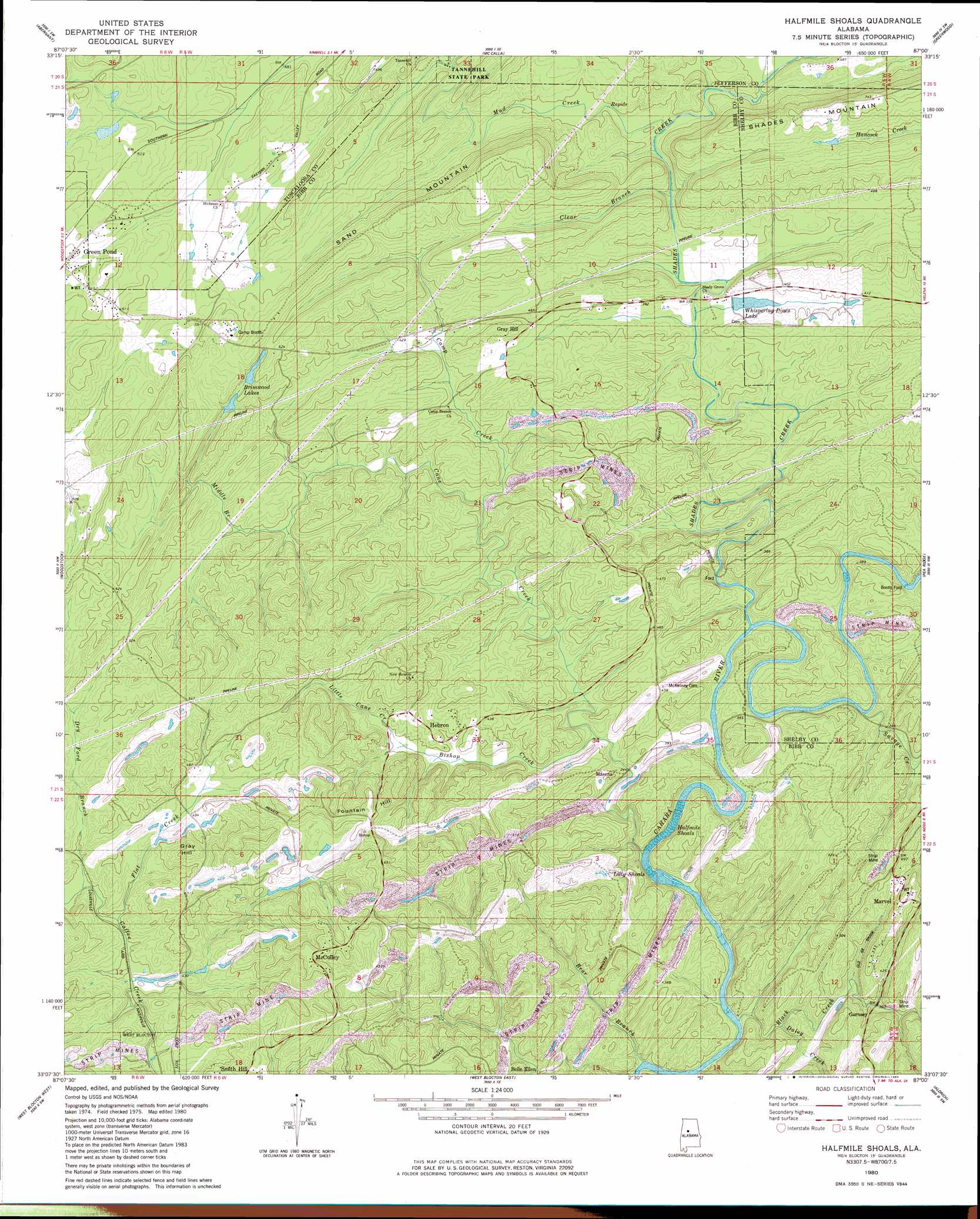
USGS Topo Quad 33087b1 - 1:24,000 scale
| Topo Map Name: | Halfmile Shoals |
| USGS Topo Quad ID: | 33087b1 |
| Print Size: | ca. 21 1/4" wide x 27" high |
| Southeast Coordinates: | 33.125° N latitude / 87° W longitude |
| Map Center Coordinates: | 33.1875° N latitude / 87.0625° W longitude |
| U.S. State: | AL |
| Filename: | o33087b1.jpg |
| Download Map JPG Image: | Halfmile Shoals topo map 1:24,000 scale |
| Map Type: | Topographic |
| Topo Series: | 7.5´ |
| Map Scale: | 1:24,000 |
| Source of Map Images: | United States Geological Survey (USGS) |
| Alternate Map Versions: |
Blocton NE AL 1975, updated 1977 Download PDF Buy paper map Halfmile Shoals AL 1980, updated 1980 Download PDF Buy paper map Halfmile Shoals AL 1980, updated 1987 Download PDF Buy paper map Halfmile Shoals AL 2011 Download PDF Buy paper map Halfmile Shoals AL 2014 Download PDF Buy paper map |
1:24,000 Topo Quads surrounding Halfmile Shoals
Burchfield Store |
Oak Grove |
Concord |
Bessemer |
Birmingham South |
Brookwood |
Abernant |
Mccalla |
Greenwood |
Helena |
Coaling |
Woodstock |
Halfmile Shoals |
Pea Ridge |
Alabaster |
Pearson |
West Blocton West |
West Blocton East |
Aldrich |
Montevallo |
Pondville |
Centreville West |
Centreville East |
Randolph |
Jemison West |
> Back to 33087a1 at 1:100,000 scale
> Back to 33086a1 at 1:250,000 scale
> Back to U.S. Topo Maps home
Halfmile Shoals topo map: Gazetteer
Halfmile Shoals: Crossings
Booth Ford elevation 95m 311′Loacke Ford elevation 93m 305′
Mitchell Ford elevation 95m 311′
Halfmile Shoals: Dams
McKnight Lake Dam elevation 155m 508′Halfmile Shoals: Mines
Coffee Creek Slope Mine elevation 171m 561′Evans Rock Slope Mine elevation 178m 583′
Peachtree Slope Mine elevation 177m 580′
Halfmile Shoals: Populated Places
Cane Creek (historical) elevation 102m 334′Garnsey elevation 126m 413′
Gray Hill elevation 134m 439′
Hebron elevation 124m 406′
Marvel elevation 159m 521′
Masena elevation 112m 367′
McCulley elevation 199m 652′
Halfmile Shoals: Rapids
Halfmile Shoals elevation 91m 298′Lilly Shoals elevation 88m 288′
Halfmile Shoals: Reservoirs
Brimwood Lakes elevation 172m 564′McKnight Lake elevation 155m 508′
Whispering Pines Lake elevation 111m 364′
Halfmile Shoals: Streams
Bear Branch elevation 83m 272′Bishop Creek elevation 102m 334′
Black Creek elevation 85m 278′
Camp Creek elevation 109m 357′
Cane Creek elevation 89m 291′
Clear Branch elevation 107m 351′
Coal Branch elevation 83m 272′
Daley Creek elevation 89m 291′
Dry Ford Branch elevation 119m 390′
Flat Creek elevation 124m 406′
Little Cane Creek elevation 119m 390′
Middle Branch elevation 114m 374′
Mud Creek elevation 109m 357′
Savage Creek elevation 96m 314′
Shades Creek elevation 96m 314′
Halfmile Shoals: Summits
Fountain Hill elevation 204m 669′Gray Hill elevation 181m 593′
Sand Mountain elevation 226m 741′
Halfmile Shoals digital topo map on disk
Buy this Halfmile Shoals topo map showing relief, roads, GPS coordinates and other geographical features, as a high-resolution digital map file on DVD: