Tuscaloosa Topo Map Alabama
To zoom in, hover over the map of Tuscaloosa
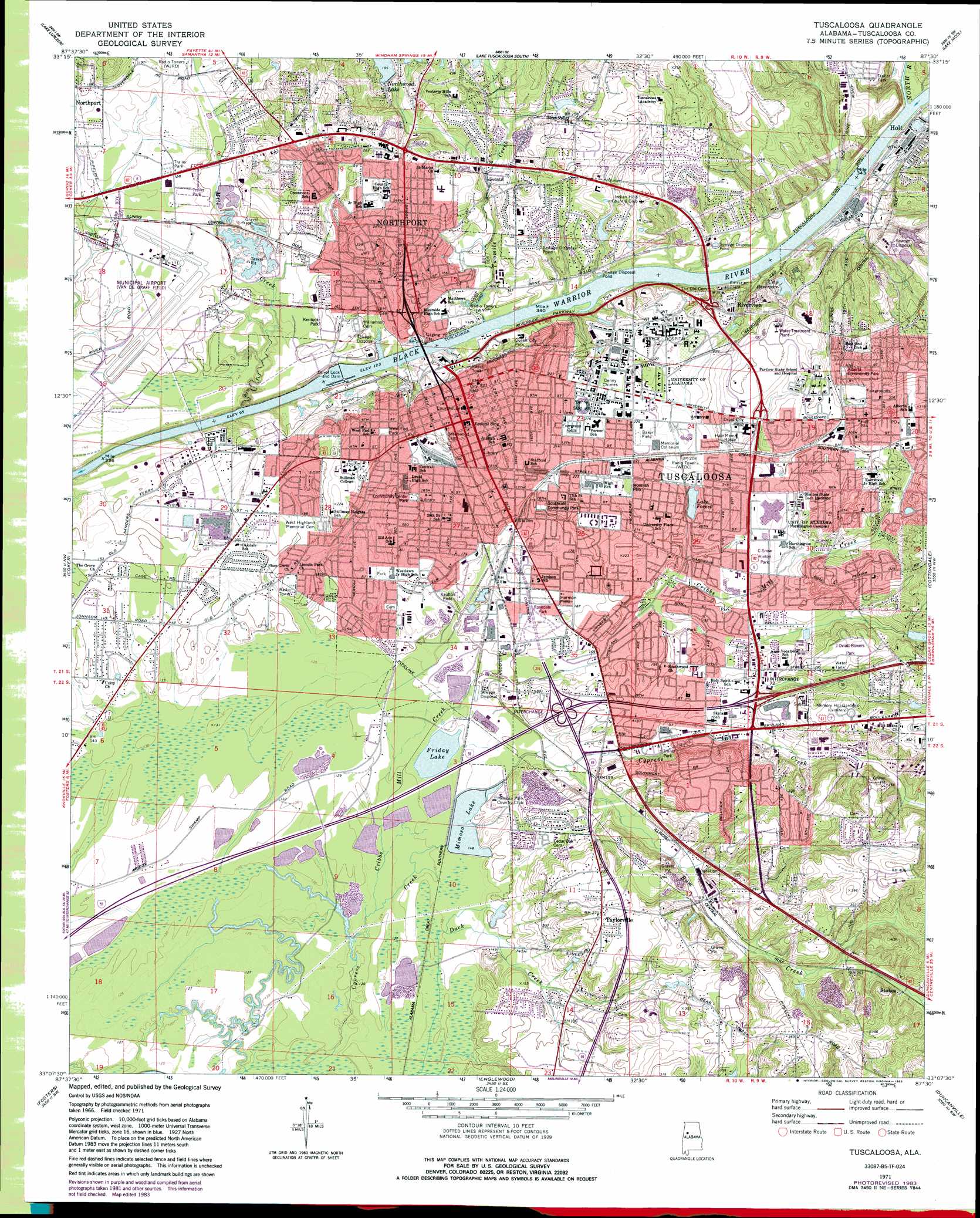
USGS Topo Quad 33087b5 - 1:24,000 scale
| Topo Map Name: | Tuscaloosa |
| USGS Topo Quad ID: | 33087b5 |
| Print Size: | ca. 21 1/4" wide x 27" high |
| Southeast Coordinates: | 33.125° N latitude / 87.5° W longitude |
| Map Center Coordinates: | 33.1875° N latitude / 87.5625° W longitude |
| U.S. State: | AL |
| Filename: | o33087b5.jpg |
| Download Map JPG Image: | Tuscaloosa topo map 1:24,000 scale |
| Map Type: | Topographic |
| Topo Series: | 7.5´ |
| Map Scale: | 1:24,000 |
| Source of Map Images: | United States Geological Survey (USGS) |
| Alternate Map Versions: |
Tuscaloosa AL 1971, updated 1973 Download PDF Buy paper map Tuscaloosa AL 1971, updated 1973 Download PDF Buy paper map Tuscaloosa AL 1971, updated 1978 Download PDF Buy paper map Tuscaloosa AL 1971, updated 1983 Download PDF Buy paper map Tuscaloosa AL 1971, updated 1983 Download PDF Buy paper map Tuscaloosa AL 2011 Download PDF Buy paper map Tuscaloosa AL 2014 Download PDF Buy paper map |
1:24,000 Topo Quads surrounding Tuscaloosa
Brownville |
Gin Creek |
Lake Tuscaloosa North |
Windham Springs |
Burchfield Store |
Elrod |
Lake Lurleen |
Lake Tuscaloosa South |
Lake Nicol |
Brookwood |
Romulus |
Coker |
Tuscaloosa |
Cottondale |
Coaling |
Ralph |
Fosters |
Englewood |
Duncanville |
Pearson |
Knoxville |
Moundville West |
Moundville East |
Payne Lake |
Pondville |
> Back to 33087a1 at 1:100,000 scale
> Back to 33086a1 at 1:250,000 scale
> Back to U.S. Topo Maps home
Tuscaloosa topo map: Gazetteer
Tuscaloosa: Airports
Bryant Culberson Airport elevation 85m 278′Tuscaloosa Municipal Airport elevation 49m 160′
Tuscaloosa: Bars
Hendricks Reef (historical) elevation 38m 124′Nelson Bar elevation 32m 104′
Plank Shoals (historical) elevation 38m 124′
Tuscaloosa Shoals (historical) elevation 38m 124′
University Shoal (historical) elevation 38m 124′
Tuscaloosa: Bridges
Hugh R Thomas Bridge elevation 38m 124′Woolsey Finnell Bridge elevation 38m 124′
Tuscaloosa: Crossings
Interchange 1 elevation 56m 183′Interchange 2 elevation 61m 200′
Interchange 71 elevation 54m 177′
Interchange 73 elevation 70m 229′
McRights Ferry (historical) elevation 38m 124′
Newtown Ferry (historical) elevation 29m 95′
Tuscaloosa: Dams
Forest Lake Dam elevation 64m 209′Friday Lake Dam elevation 41m 134′
Indian Hills Lake Dam elevation 57m 187′
Little Reservoir Dam elevation 62m 203′
McPherson Number 1 Dam elevation 54m 177′
Mimosa Park Dam elevation 45m 147′
Northwood Lake Dam elevation 60m 196′
Oliver Lock and Dam elevation 29m 95′
Sewage Lagoon Dam North elevation 43m 141′
Sewage Lagoon Dam South elevation 43m 141′
Tuscaloosa: Falls
University Falls (historical) elevation 39m 127′Tuscaloosa: Flats
Dalys Bottom elevation 66m 216′Holman Bottom elevation 52m 170′
Pine Flat elevation 67m 219′
Tuscaloosa: Islands
Big Island (historical) elevation 38m 124′Tuscaloosa: Lakes
Friday Lake elevation 41m 134′Tuscaloosa: Parks
Alberta Community Park elevation 92m 301′Audubon Place Historic District elevation 66m 216′
Baker Field elevation 67m 219′
Bryant-Denny Stadium elevation 67m 219′
C Snow Hinton Park elevation 68m 223′
Capitol Park elevation 67m 219′
Caplewood Drive Historic District elevation 66m 216′
Community Center Park elevation 61m 200′
Downtown Tuscaloosa Historic District elevation 68m 223′
Druid City Historic District elevation 71m 232′
Eastwood Park elevation 67m 219′
Falcon Field elevation 67m 219′
Gorgas-Manley Historic District elevation 68m 223′
Gribbin Park elevation 67m 219′
Harmon Field elevation 57m 187′
J Oviatt Bowers Park elevation 95m 311′
Kaulton Field elevation 48m 157′
Kentuck Park elevation 45m 147′
Monnish Park elevation 67m 219′
Northport Historic District elevation 50m 164′
Northport Main Street Park elevation 55m 180′
Pinehurst Historic District elevation 62m 203′
Queen City Park elevation 46m 150′
Rosedale Park elevation 57m 187′
Southside Park elevation 62m 203′
Stafford Park elevation 67m 219′
West End Park elevation 65m 213′
Wildcat Stadium elevation 68m 223′
Tuscaloosa: Populated Places
Academy Drive elevation 77m 252′Alberta City elevation 91m 298′
Alberta Heights elevation 97m 318′
Alta Vista elevation 67m 219′
Arlington Drive elevation 61m 200′
Arlington Mobile Home Park (historical) elevation 55m 180′
Audubon Place elevation 67m 219′
Bar Wayne Circle elevation 92m 301′
Bellview Heights elevation 91m 298′
Bellwood elevation 65m 213′
Beverley Heights elevation 88m 288′
Birdway Drive elevation 65m 213′
Biscayne Hills elevation 80m 262′
Brookhaven elevation 68m 223′
Brookmeade elevation 62m 203′
Brooksdale elevation 59m 193′
Brookside elevation 51m 167′
Buckhead elevation 55m 180′
Buena Vista elevation 89m 291′
Burks Garden elevation 60m 196′
Camellia Park elevation 53m 173′
Candlelight Terrace elevation 83m 272′
Capstone Court elevation 56m 183′
Carriage Lane elevation 75m 246′
Carter Subdivision elevation 41m 134′
Cedar Crest elevation 64m 209′
Cedar Knoll elevation 75m 246′
Cherokee Hills elevation 99m 324′
Cherry Dale elevation 59m 193′
Circlewood elevation 71m 232′
Cloverdale elevation 66m 216′
College Hills elevation 50m 164′
Colonial Hills elevation 79m 259′
Country Club Gables elevation 60m 196′
Country Club Hills elevation 67m 219′
Coventry elevation 87m 285′
Covey Chase elevation 88m 288′
Crestdale elevation 68m 223′
Crestmont elevation 65m 213′
Crestview elevation 57m 187′
Crestwood elevation 55m 180′
Dearing Place elevation 67m 219′
Deven Dale elevation 59m 193′
Dixon Manor elevation 60m 196′
Dunbrook elevation 83m 272′
Durrett Grove elevation 101m 331′
Dutton Place elevation 76m 249′
East Arlington elevation 61m 200′
East Circle elevation 44m 144′
East End elevation 67m 219′
Eastwood Villa elevation 89m 291′
Echo Hill elevation 79m 259′
Fairlawn elevation 47m 154′
Fairway Drive elevation 67m 219′
Fernridge elevation 45m 147′
Fernwood elevation 63m 206′
Fitts Heights elevation 64m 209′
Forest Hills elevation 61m 200′
Forest Lake elevation 68m 223′
Forest Manor elevation 64m 209′
Fox Run elevation 80m 262′
Gardendale elevation 43m 141′
Glendale Gardens elevation 68m 223′
Green Hills elevation 64m 209′
Green Valley elevation 50m 164′
Greenbriar elevation 60m 196′
Greenview elevation 48m 157′
Guilds Woods elevation 52m 170′
Happy Acres elevation 68m 223′
Harper Subdivision elevation 50m 164′
Hays Court elevation 49m 160′
Heritage Hills elevation 67m 219′
Hickory Forest elevation 63m 206′
High Forest elevation 67m 219′
Hightown elevation 70m 229′
Hillcrest elevation 65m 213′
Hollywood Park elevation 46m 150′
Howton Subdivision elevation 90m 295′
Idlewood elevation 79m 259′
Indian Hills elevation 71m 232′
Indian Lake elevation 73m 239′
Ingleside Village elevation 56m 183′
Jerusalem Heights elevation 102m 334′
Juanita Drive elevation 101m 331′
Kennedy Park elevation 72m 236′
Kicker Subdivision elevation 94m 308′
Kings Acres elevation 40m 131′
La Vera elevation 86m 282′
Lake Forest elevation 67m 219′
Lake Shore elevation 93m 305′
Lakeview elevation 65m 213′
Lincoln Park elevation 52m 170′
Livingston Subdivision elevation 61m 200′
Lynwood Park elevation 76m 249′
Manora Estates elevation 58m 190′
McKenzie Courts elevation 57m 187′
Meadow Lawn elevation 54m 177′
Meadowbrook elevation 63m 206′
Mimosa Highlands elevation 69m 226′
Mimosa Manor elevation 54m 177′
Morayshire Estates elevation 61m 200′
Northport elevation 67m 219′
Oak Ridge elevation 58m 190′
Oakdale elevation 49m 160′
Oliver Heights elevation 66m 216′
Parkside elevation 100m 328′
Parkview elevation 67m 219′
Parkwood elevation 54m 177′
Patton Place elevation 89m 291′
Pearson Subdivision elevation 43m 141′
Pine Hills elevation 89m 291′
Pine Park elevation 88m 288′
Pinehurst elevation 71m 232′
Princeton Heights elevation 69m 226′
Princeton Place elevation 72m 236′
Reston Place elevation 49m 160′
Ridgeland elevation 101m 331′
Riverchase elevation 92m 301′
Riverdale elevation 77m 252′
Rivermont elevation 47m 154′
Riverside Circle elevation 63m 206′
Riverview elevation 70m 229′
Riverwood elevation 67m 219′
Rollingwood elevation 49m 160′
Rosedale elevation 55m 180′
Rosedale Courts elevation 56m 183′
Roselawn elevation 67m 219′
Rosewood elevation 81m 265′
Royal Pines elevation 46m 150′
Running Brook elevation 116m 380′
Sahama Village elevation 52m 170′
Sherwood elevation 51m 167′
Sky Ranch elevation 116m 380′
Skyland Manor elevation 89m 291′
Skyland Park elevation 90m 295′
Smith Acres elevation 52m 170′
Snow Terrace elevation 52m 170′
Sommerville elevation 56m 183′
South Park elevation 58m 190′
Southwood elevation 55m 180′
Spring Brook elevation 59m 193′
Stokes elevation 107m 351′
Sutton Place elevation 90m 295′
Sycamore elevation 78m 255′
Taylor Circle elevation 45m 147′
Taylorville elevation 83m 272′
Taylorville Heights elevation 85m 278′
Taylorwood Estates elevation 111m 364′
Terri Wood elevation 62m 203′
The Downs elevation 64m 209′
The Glens elevation 47m 154′
The Highlands elevation 83m 272′
The Vineyards elevation 71m 232′
Timberlane elevation 72m 236′
Tuscaloosa elevation 67m 219′
Twin Manor elevation 69m 226′
University Lane elevation 56m 183′
University Manor elevation 53m 173′
University Place elevation 68m 223′
Valley View elevation 89m 291′
Vestavia East elevation 71m 232′
Vestavia Hills elevation 66m 216′
Warrior Heights elevation 70m 229′
Washington Square elevation 49m 160′
West Circle elevation 52m 170′
West Haven elevation 55m 180′
Westridge elevation 69m 226′
Wood Manor elevation 65m 213′
Wood Ridge elevation 63m 206′
Wood Villas elevation 84m 275′
Tuscaloosa: Post Offices
Downtown Station Tuscaloosa Post Office (historical) elevation 66m 216′East Side Station Tuscaloosa Post Office elevation 99m 324′
Holt Post Office elevation 55m 180′
Northport Post Office elevation 75m 246′
Tuscaloosa Post Office elevation 67m 219′
University Post Office elevation 68m 223′
Tuscaloosa: Reservoirs
Indian Hills Lake elevation 57m 187′Indian Lake elevation 66m 216′
Lake Forest elevation 63m 206′
Little Reservoir elevation 62m 203′
Mimosa Lake elevation 43m 141′
Northwood Lake elevation 60m 196′
Sewage Lagoon North elevation 43m 141′
Sewage Lagoon South elevation 43m 141′
William Bacon Oliver Lake elevation 29m 95′
Tuscaloosa: Springs
Marrs Spring elevation 57m 187′Tuscaloosa: Streams
Cribbs Mill Creek elevation 38m 124′Mill Creek elevation 32m 104′
North River elevation 38m 124′
Rum Creek elevation 49m 160′
Twomile Creek elevation 44m 144′
University Branch elevation 39m 127′
Tuscaloosa: Summits
Childress Hill elevation 68m 223′Holman Hill elevation 69m 226′
River Hill elevation 69m 226′
Tuscaloosa: Swamps
Moodys Swamp elevation 40m 131′Tuscaloosa digital topo map on disk
Buy this Tuscaloosa topo map showing relief, roads, GPS coordinates and other geographical features, as a high-resolution digital map file on DVD: