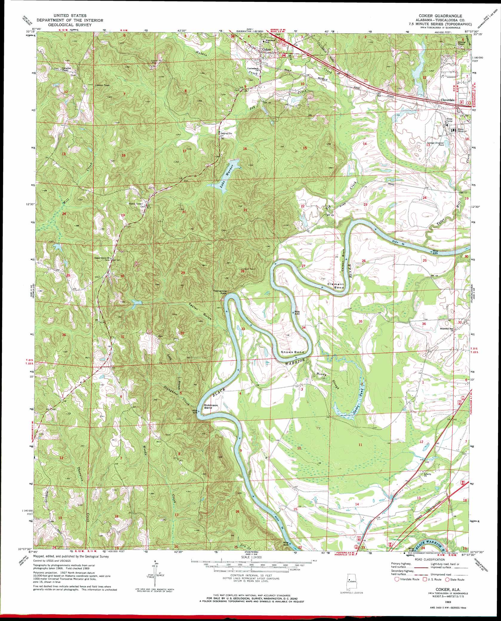
Coker Topo Map Alabama
To zoom in, hover over the map of Coker
USGS Topo Quad 33087b6 - 1:24,000 scale
| Topo Map Name: | Coker |
| USGS Topo Quad ID: | 33087b6 |
| Print Size: | ca. 21 1/4" wide x 27" high |
| Southeast Coordinates: | 33.125° N latitude / 87.625° W longitude |
| Map Center Coordinates: | 33.1875° N latitude / 87.6875° W longitude |
| U.S. State: | AL |
| Filename: | o33087b6.jpg |
| Download Map JPG Image: | Coker topo map 1:24,000 scale |
| Map Type: | Topographic |
| Topo Series: | 7.5´ |
| Map Scale: | 1:24,000 |
| Source of Map Images: | United States Geological Survey (USGS) |
| Alternate Map Versions: |
Coker AL 1969, updated 1973 Download PDF Buy paper map Coker AL 1969, updated 1978 Download PDF Buy paper map Coker AL 1969, updated 1978 Download PDF Buy paper map Coker AL 2011 Download PDF Buy paper map Coker AL 2014 Download PDF Buy paper map |
1:24,000 Topo Quads surrounding Coker
Palmetto |
Brownville |
Gin Creek |
Lake Tuscaloosa North |
Windham Springs |
Gordo |
Elrod |
Lake Lurleen |
Lake Tuscaloosa South |
Lake Nicol |
Kirk |
Romulus |
Coker |
Tuscaloosa |
Cottondale |
Mantua |
Ralph |
Fosters |
Englewood |
Duncanville |
Union |
Knoxville |
Moundville West |
Moundville East |
Payne Lake |
> Back to 33087a1 at 1:100,000 scale
> Back to 33086a1 at 1:250,000 scale
> Back to U.S. Topo Maps home
Coker topo map: Gazetteer
Coker: Bars
Blue Rock elevation 40m 131′Five Mile Rock elevation 32m 104′
Coker: Bends
Clement Bend elevation 40m 131′Marr Bend elevation 40m 131′
Robinson Bend elevation 42m 137′
Snows Bend elevation 40m 131′
Coker: Cliffs
Carson Bluff elevation 40m 131′Reed Bluff elevation 40m 131′
Coker: Crossings
Sanders Ferry (historical) elevation 33m 108′Coker: Dams
Bryce Hospital Dam elevation 45m 147′Jaycee Partlow Dam Number One elevation 50m 164′
Jaycee Partlow Dam Number Two elevation 48m 157′
Lake Tina Dam elevation 40m 131′
Mildred Warner Dam elevation 63m 206′
Russell Lee Lake Dam elevation 41m 134′
Skelton Number 1 Dam elevation 63m 206′
Coker: Islands
Twelvemile Rock elevation 63m 206′Coker: Lakes
Goose Pond elevation 38m 124′Coker: Populated Places
Berkshire Estates elevation 43m 141′Booth Estates elevation 56m 183′
Cloverdale elevation 52m 170′
Coker elevation 63m 206′
Coker Heights elevation 67m 219′
Deerfield elevation 55m 180′
Forest Green elevation 68m 223′
Forest Green Park elevation 70m 229′
Harperwood elevation 81m 265′
Lake Robinwood Subdivision elevation 48m 157′
Lisenba Subdivision elevation 118m 387′
Lurleen Estates elevation 58m 190′
Pine Circle elevation 67m 219′
Romulus Acres elevation 85m 278′
Simpson Subdivision elevation 55m 180′
Valliwood elevation 61m 200′
Wensa Place elevation 68m 223′
Western Plains elevation 55m 180′
Westland elevation 58m 190′
Coker: Post Offices
Coker Post Office elevation 60m 196′Coker: Reservoirs
Bryce Hospital Lake elevation 45m 147′Lake Robinwood elevation 47m 154′
Lake Tina elevation 40m 131′
Lake Warner elevation 67m 219′
Partlow Lake Lower elevation 48m 157′
Partlow Lake Upper elevation 50m 164′
Russell Lee Lake elevation 41m 134′
Coker: Streams
Big Creek elevation 40m 131′Jay Creek elevation 41m 134′
Little Branch elevation 42m 137′
Moody Slough elevation 33m 108′
Nubbin Creek elevation 49m 160′
Potatoe Creek elevation 40m 131′
Sanders Mill Creek elevation 29m 95′
Slaughter Creek elevation 30m 98′
Tater Hill Creek elevation 36m 118′
Venable Creek elevation 33m 108′
Coker: Valleys
Taylor Gulch elevation 35m 114′Coker digital topo map on disk
Buy this Coker topo map showing relief, roads, GPS coordinates and other geographical features, as a high-resolution digital map file on DVD: