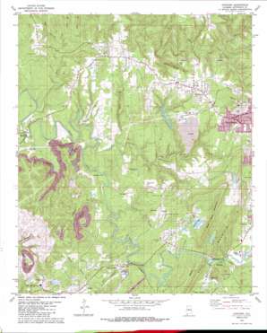
Concord Topo Map Alabama
To zoom in, hover over the map of Concord
USGS Topo Quad 33087d1 - 1:24,000 scale
| Topo Map Name: | Concord |
| USGS Topo Quad ID: | 33087d1 |
| Print Size: | ca. 21 1/4" wide x 27" high |
| Southeast Coordinates: | 33.375° N latitude / 87° W longitude |
| Map Center Coordinates: | 33.4375° N latitude / 87.0625° W longitude |
| U.S. State: | AL |
| Filename: | o33087d1.jpg |
| Download Map JPG Image: | Concord topo map 1:24,000 scale |
| Map Type: | Topographic |
| Topo Series: | 7.5´ |
| Map Scale: | 1:24,000 |
| Source of Map Images: | United States Geological Survey (USGS) |
| Alternate Map Versions: |
Yolande NE AL 1975, updated 1977 Download PDF Buy paper map Concord AL 1979, updated 1980 Download PDF Buy paper map Concord AL 1979, updated 1987 Download PDF Buy paper map Concord AL 2011 Download PDF Buy paper map Concord AL 2014 Download PDF Buy paper map |
1:24,000 Topo Quads surrounding Concord
> Back to 33087a1 at 1:100,000 scale
> Back to 33086a1 at 1:250,000 scale
> Back to U.S. Topo Maps home
Concord topo map: Gazetteer
Concord: Crossings
Starvacre Ford elevation 113m 370′Concord: Dams
Blue Creek Mine Number 3-Impoundment Number 1 Dam elevation 152m 498′Blue Creek Mine Number 3-Impoundment Number Z Dam elevation 175m 574′
Concord Mines Lake Dam elevation 162m 531′
Lake Martin Dam elevation 136m 446′
Lake View Dam elevation 135m 442′
North Highlands Lake Dam elevation 228m 748′
Concord: Lakes
Martin Lake elevation 135m 442′Concord: Mines
Adger Mine elevation 140m 459′Blue Creek Number 3 Mine elevation 186m 610′
Concord Mine elevation 171m 561′
Jagger Mine elevation 178m 583′
Oak Grove Mine elevation 181m 593′
Virginia Mine elevation 147m 482′
Concord: Populated Places
Adger elevation 144m 472′Bullard Shoals (historical) elevation 134m 439′
Concord elevation 181m 593′
Hopkins elevation 179m 587′
Lakeview Estates elevation 150m 492′
McAdory elevation 179m 587′
Rock Creek elevation 179m 587′
Valley Creek elevation 141m 462′
Virginia elevation 136m 446′
Concord: Post Offices
Adger Post Office elevation 137m 449′Concord: Reservoirs
Atchisons Lake elevation 148m 485′Blue Creek Mine Number 3 - Impoundment elevation 152m 498′
Blue Creek Mine Number 3 - Impoundment elevation 175m 574′
Concord Mine Lake elevation 162m 531′
Jug Hollow Lake elevation 135m 442′
Lake View Estates Lakes elevation 136m 446′
Concord: Streams
Bear Branch elevation 97m 318′Black Branch elevation 109m 357′
Blue Creek elevation 113m 370′
Dry Branch elevation 96m 314′
Fivemile Creek elevation 128m 419′
Johnson Branch elevation 107m 351′
Lick Branch elevation 91m 298′
Lick Creek elevation 98m 321′
Little Blue Creek elevation 120m 393′
Little Lick Creek elevation 101m 331′
Lost Branch elevation 98m 321′
Lost Creek elevation 113m 370′
Raccoon Branch elevation 91m 298′
Rock Creek elevation 91m 298′
Roscoe Spring Branch elevation 105m 344′
Sherret Branch elevation 116m 380′
Simmons Branch elevation 115m 377′
Concord: Summits
Clarke Mountain elevation 232m 761′West Rock Mountain elevation 247m 810′
Concord: Valleys
Rockhouse Hollow elevation 122m 400′Concord digital topo map on disk
Buy this Concord topo map showing relief, roads, GPS coordinates and other geographical features, as a high-resolution digital map file on DVD:


