Windham Springs Topo Map Alabama
To zoom in, hover over the map of Windham Springs
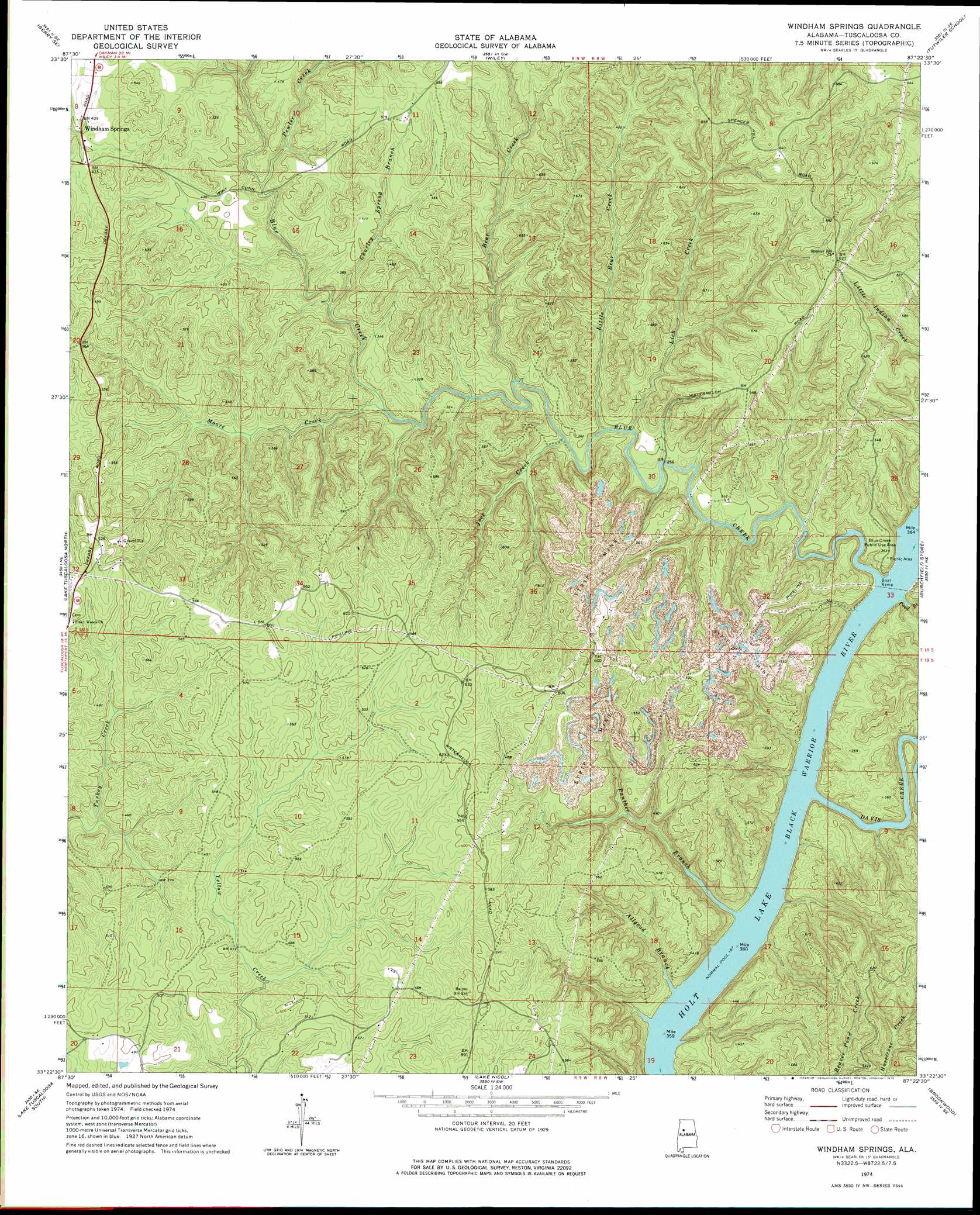
USGS Topo Quad 33087d4 - 1:24,000 scale
| Topo Map Name: | Windham Springs |
| USGS Topo Quad ID: | 33087d4 |
| Print Size: | ca. 21 1/4" wide x 27" high |
| Southeast Coordinates: | 33.375° N latitude / 87.375° W longitude |
| Map Center Coordinates: | 33.4375° N latitude / 87.4375° W longitude |
| U.S. State: | AL |
| Filename: | o33087d4.jpg |
| Download Map JPG Image: | Windham Springs topo map 1:24,000 scale |
| Map Type: | Topographic |
| Topo Series: | 7.5´ |
| Map Scale: | 1:24,000 |
| Source of Map Images: | United States Geological Survey (USGS) |
| Alternate Map Versions: |
Windham Springs AL 1974, updated 1976 Download PDF Buy paper map Windham Springs AL 2011 Download PDF Buy paper map Windham Springs AL 2014 Download PDF Buy paper map |
1:24,000 Topo Quads surrounding Windham Springs
Bankston |
Berry |
Oakman |
Parrish |
Goodsprings |
New Lexington |
Berry Se |
Wiley |
Tutwiler School |
Gilmore |
Gin Creek |
Lake Tuscaloosa North |
Windham Springs |
Burchfield Store |
Oak Grove |
Lake Lurleen |
Lake Tuscaloosa South |
Lake Nicol |
Brookwood |
Abernant |
Coker |
Tuscaloosa |
Cottondale |
Coaling |
Woodstock |
> Back to 33087a1 at 1:100,000 scale
> Back to 33086a1 at 1:250,000 scale
> Back to U.S. Topo Maps home
Windham Springs topo map: Gazetteer
Windham Springs: Bars
Crowder Shoals (historical) elevation 57m 187′Fair Shoals (historical) elevation 57m 187′
Windham Springs: Crossings
Walton Road Ford elevation 127m 416′Windham Springs: Dams
Lock Number Eight (historical) elevation 57m 187′Windham Springs: Lakes
Harolds Lake (historical) elevation 57m 187′Windham Springs: Mines
Blue Creek Number 2 Mine elevation 164m 538′Emily Number 5 Mine elevation 140m 459′
Turkey Creek Mine elevation 128m 419′
Windham Springs: Parks
Blue Creek Public Use Area elevation 105m 344′Windham Springs: Populated Places
Windham Springs elevation 122m 400′Windham Springs: Streams
Allgood Branch elevation 57m 187′Bear Creek elevation 104m 341′
Blue Creek elevation 57m 187′
Charley Spring Branch elevation 101m 331′
Davis Creek elevation 58m 190′
Jock Creek elevation 84m 275′
Lick Creek elevation 82m 269′
Little Bear Creek elevation 87m 285′
Little Blue Creek elevation 79m 259′
McDuff Spring Branch elevation 96m 314′
Moore Creek elevation 83m 272′
Panther Branch elevation 57m 187′
Pewter Creek elevation 106m 347′
Pond Branch elevation 57m 187′
Windham Springs digital topo map on disk
Buy this Windham Springs topo map showing relief, roads, GPS coordinates and other geographical features, as a high-resolution digital map file on DVD: