Parrish Topo Map Alabama
To zoom in, hover over the map of Parrish
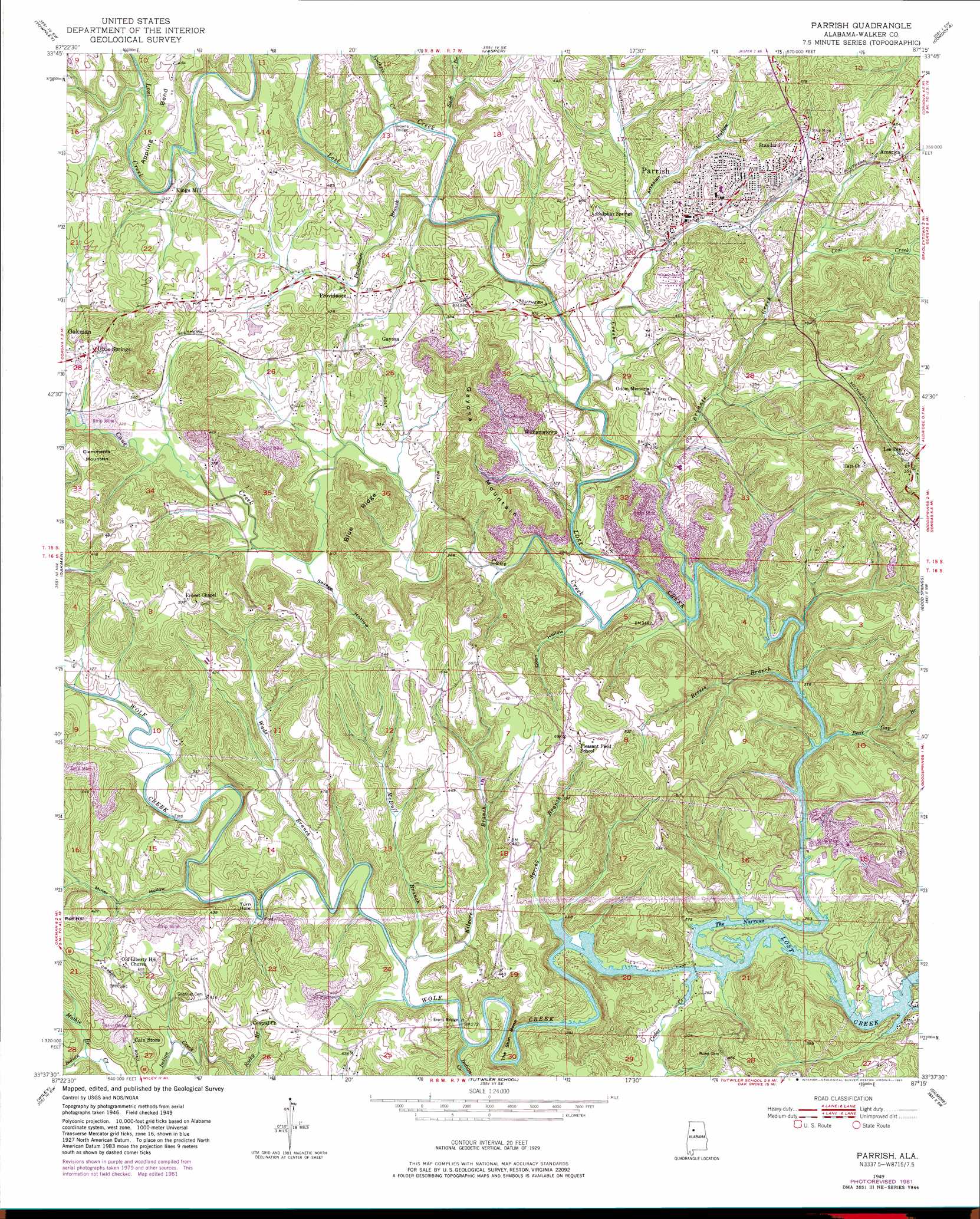
USGS Topo Quad 33087f3 - 1:24,000 scale
| Topo Map Name: | Parrish |
| USGS Topo Quad ID: | 33087f3 |
| Print Size: | ca. 21 1/4" wide x 27" high |
| Southeast Coordinates: | 33.625° N latitude / 87.25° W longitude |
| Map Center Coordinates: | 33.6875° N latitude / 87.3125° W longitude |
| U.S. State: | AL |
| Filename: | o33087f3.jpg |
| Download Map JPG Image: | Parrish topo map 1:24,000 scale |
| Map Type: | Topographic |
| Topo Series: | 7.5´ |
| Map Scale: | 1:24,000 |
| Source of Map Images: | United States Geological Survey (USGS) |
| Alternate Map Versions: |
Parrish AL 1949, updated 1967 Download PDF Buy paper map Parrish AL 1949, updated 1981 Download PDF Buy paper map Parrish AL 1951 Download PDF Buy paper map Parrish AL 2011 Download PDF Buy paper map Parrish AL 2014 Download PDF Buy paper map |
1:24,000 Topo Quads surrounding Parrish
Carbon Hill |
Nauvoo |
Manchester |
Sunlight |
Cold Springs |
Howard |
Townley |
Jasper |
Cordova |
Sipsey |
Berry |
Oakman |
Parrish |
Goodsprings |
Dora |
Berry Se |
Wiley |
Tutwiler School |
Gilmore |
Sylvan Springs |
Lake Tuscaloosa North |
Windham Springs |
Burchfield Store |
Oak Grove |
Concord |
> Back to 33087e1 at 1:100,000 scale
> Back to 33086a1 at 1:250,000 scale
> Back to U.S. Topo Maps home
Parrish topo map: Gazetteer
Parrish: Bends
Appling Bend elevation 113m 370′The Shin Bone elevation 109m 357′
Turn Hole elevation 86m 282′
Parrish: Bridges
Browns Bridge elevation 84m 275′Evans Bridge elevation 79m 259′
Prices Bridge elevation 77m 252′
Parrish: Channels
The Narrows elevation 79m 259′Parrish: Dams
Strip Mining Impoundment Dam Number 1 elevation 98m 321′Parrish: Mines
Atlas Mines elevation 100m 328′Bryant Creek Mine elevation 135m 442′
Busby Mine elevation 117m 383′
Craft Mine elevation 80m 262′
Dave Cobb Mine elevation 124m 406′
Deer Creek Mine elevation 149m 488′
Dixie Springs Mine elevation 137m 449′
Garrington Spring Mine elevation 135m 442′
Gayosa Mine elevation 135m 442′
Gorgas Mine elevation 140m 459′
Herron Number 4 Mine elevation 119m 390′
Hewett Mine elevation 155m 508′
Liberty Hill Number 3 Mine elevation 136m 446′
Mary Lee Number 1 Mine elevation 86m 282′
Moss American Mine elevation 129m 423′
Parrish Drift Mine elevation 124m 406′
Pratt Number 1 Mine elevation 135m 442′
Red Bud Mine elevation 160m 524′
Segco Mine elevation 151m 495′
Standard Mine elevation 172m 564′
Parrish: Populated Places
America elevation 135m 442′Cedar Lake elevation 80m 262′
Dixie Springs elevation 115m 377′
Gayosa elevation 107m 351′
Kings Mill elevation 101m 331′
Parrish elevation 116m 380′
Pleasant Field elevation 154m 505′
Providence elevation 94m 308′
Standard elevation 142m 465′
Williamstown elevation 109m 357′
Parrish: Reservoirs
Strip Mining Impoundment Number 1 elevation 98m 321′Parrish: Ridges
Blue Ridge elevation 150m 492′Parrish: Streams
Bear Gap Branch elevation 79m 259′Bryants Creek elevation 79m 259′
Cane Creek elevation 79m 259′
Cedar Creek elevation 78m 255′
Coal Creek elevation 103m 337′
Guthrie Creek elevation 84m 275′
Indian Creek elevation 78m 255′
Indian Creek elevation 79m 259′
Kilgore Branch elevation 79m 259′
Martin Branch elevation 98m 321′
Mathie Branch elevation 90m 295′
McDuff Branch elevation 79m 259′
Providence Branch elevation 83m 272′
Reeses Branch elevation 79m 259′
Spring Branch elevation 78m 255′
Suck Branch elevation 85m 278′
Wade Branch elevation 79m 259′
Wolf Creek elevation 77m 252′
Parrish: Summits
Gayosa Mountain elevation 170m 557′Parrish: Valleys
Artesian Hollow elevation 95m 311′Coon Hollow elevation 80m 262′
Miner Hollow elevation 79m 259′
Savage Hollow elevation 90m 295′
Parrish digital topo map on disk
Buy this Parrish topo map showing relief, roads, GPS coordinates and other geographical features, as a high-resolution digital map file on DVD: