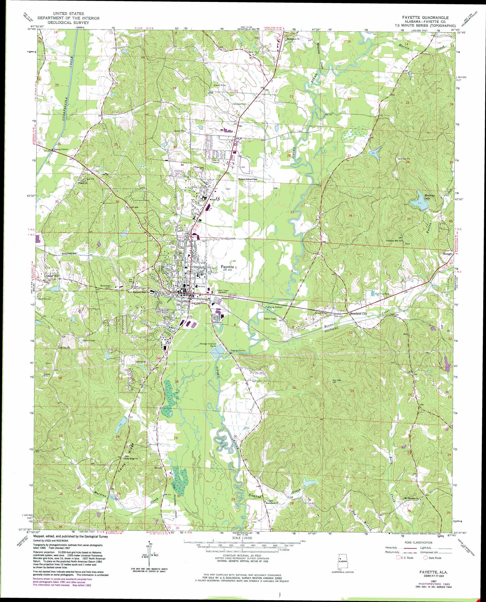
Fayette Topo Map Alabama
To zoom in, hover over the map of Fayette
USGS Topo Quad 33087f7 - 1:24,000 scale
| Topo Map Name: | Fayette |
| USGS Topo Quad ID: | 33087f7 |
| Print Size: | ca. 21 1/4" wide x 27" high |
| Southeast Coordinates: | 33.625° N latitude / 87.75° W longitude |
| Map Center Coordinates: | 33.6875° N latitude / 87.8125° W longitude |
| U.S. State: | AL |
| Filename: | o33087f7.jpg |
| Download Map JPG Image: | Fayette topo map 1:24,000 scale |
| Map Type: | Topographic |
| Topo Series: | 7.5´ |
| Map Scale: | 1:24,000 |
| Source of Map Images: | United States Geological Survey (USGS) |
| Alternate Map Versions: |
Fayette AL 1967, updated 1968 Download PDF Buy paper map Fayette AL 1967, updated 1983 Download PDF Buy paper map Fayette AL 2011 Download PDF Buy paper map Fayette AL 2014 Download PDF Buy paper map |
1:24,000 Topo Quads surrounding Fayette
Beaverton |
Guin |
Winfield |
Glen Allen |
Carbon Hill |
Vernon |
Bluff |
Winfield Se |
Hubbertville |
Howard |
Hightogy |
Belk |
Fayette |
Bankston |
Berry |
Millport |
Kennedy |
Newtonville |
New Lexington |
Berry Se |
Reform |
Palmetto |
Brownville |
Gin Creek |
Lake Tuscaloosa North |
> Back to 33087e1 at 1:100,000 scale
> Back to 33086a1 at 1:250,000 scale
> Back to U.S. Topo Maps home
Fayette topo map: Gazetteer
Fayette: Airports
Richard Arthur Field elevation 105m 344′Fayette: Dams
Bagwell Lake Dam elevation 128m 419′Cains Ridge Dam elevation 103m 337′
Harkins Lake Dam elevation 127m 416′
Fayette: Oilfields
Fayette Gas Field elevation 97m 318′Musgrove Creek Gas Field elevation 104m 341′
North Fayette Gas Field elevation 122m 400′
West McCracken Mountain Gas Field elevation 152m 498′
Fayette: Parks
Fayette County Courthouse Historic District elevation 111m 364′Guthrie Smith Park elevation 108m 354′
John Morgan Brown Stadium elevation 105m 344′
Fayette: Populated Places
Cedar Hill elevation 123m 403′Fayette elevation 111m 364′
Gumbud elevation 99m 324′
Old Town elevation 141m 462′
Rossland City elevation 102m 334′
Fayette: Post Offices
Fayette Post Office elevation 109m 357′Pilgrims Rest Post Office (historical) elevation 125m 410′
Fayette: Reservoirs
Bagwell Lake elevation 128m 419′Cains Ridge Lake elevation 103m 337′
Harkins Lake elevation 127m 416′
Fayette: Ridges
Cains Ridge elevation 153m 501′Fayette: Streams
Boxes Creek elevation 97m 318′Fulton Creek elevation 109m 357′
Gumbud Creek elevation 92m 301′
Harris Creek elevation 104m 341′
Musgrove Creek elevation 104m 341′
Fayette digital topo map on disk
Buy this Fayette topo map showing relief, roads, GPS coordinates and other geographical features, as a high-resolution digital map file on DVD: