Hubbertville Topo Map Alabama
To zoom in, hover over the map of Hubbertville
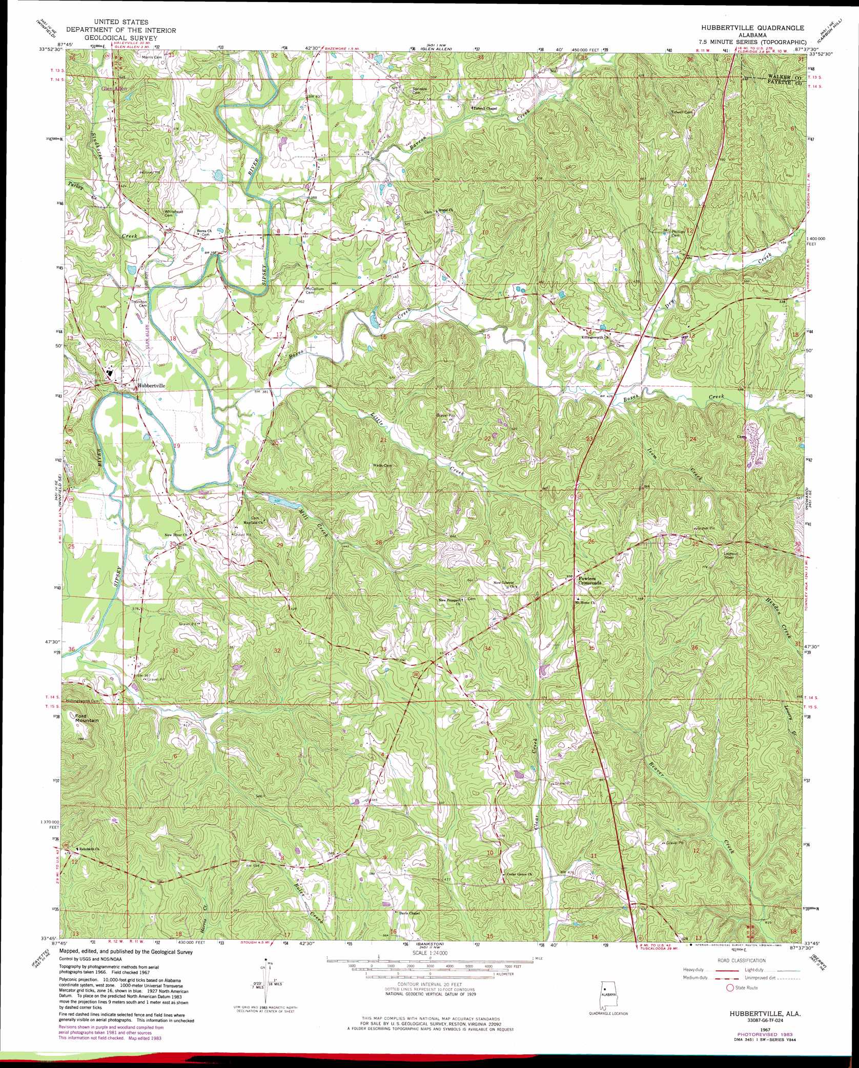
USGS Topo Quad 33087g6 - 1:24,000 scale
| Topo Map Name: | Hubbertville |
| USGS Topo Quad ID: | 33087g6 |
| Print Size: | ca. 21 1/4" wide x 27" high |
| Southeast Coordinates: | 33.75° N latitude / 87.625° W longitude |
| Map Center Coordinates: | 33.8125° N latitude / 87.6875° W longitude |
| U.S. State: | AL |
| Filename: | o33087g6.jpg |
| Download Map JPG Image: | Hubbertville topo map 1:24,000 scale |
| Map Type: | Topographic |
| Topo Series: | 7.5´ |
| Map Scale: | 1:24,000 |
| Source of Map Images: | United States Geological Survey (USGS) |
| Alternate Map Versions: |
Hubbertville AL 1967, updated 1968 Download PDF Buy paper map Hubbertville AL 1967, updated 1983 Download PDF Buy paper map Hubbertville AL 2011 Download PDF Buy paper map Hubbertville AL 2014 Download PDF Buy paper map |
1:24,000 Topo Quads surrounding Hubbertville
Hamilton Sw |
Brilliant |
Gold Mine |
Lynn |
Poplar Springs |
Guin |
Winfield |
Glen Allen |
Carbon Hill |
Nauvoo |
Bluff |
Winfield Se |
Hubbertville |
Howard |
Townley |
Belk |
Fayette |
Bankston |
Berry |
Oakman |
Kennedy |
Newtonville |
New Lexington |
Berry Se |
Wiley |
> Back to 33087e1 at 1:100,000 scale
> Back to 33086a1 at 1:250,000 scale
> Back to U.S. Topo Maps home
Hubbertville topo map: Gazetteer
Hubbertville: Bridges
McCollum Bridge elevation 110m 360′Hubbertville: Oilfields
Boxes Creek Gas Field elevation 131m 429′Davis Chapel Gas Field elevation 149m 488′
Hubbertsville Gas Field elevation 111m 364′
Northeast Davis Chapel Gas Field elevation 197m 646′
Hubbertville: Parks
Wiley Hollingsworth Stadium elevation 133m 436′Hubbertville: Populated Places
Fowlers Crossroads elevation 201m 659′Hubbertville elevation 130m 426′
Hubbertville: Streams
Barron Creek elevation 116m 380′Boxes Creek elevation 110m 360′
Dry Creek elevation 126m 413′
Hollingsworth Mill Creek elevation 107m 351′
Isom Creek elevation 127m 416′
Little Creek elevation 115m 377′
Mill Creek elevation 112m 367′
Studhorse Creek elevation 115m 377′
Turkey Creek elevation 120m 393′
Hubbertville: Summits
Ford Mountain elevation 243m 797′Hubbertville digital topo map on disk
Buy this Hubbertville topo map showing relief, roads, GPS coordinates and other geographical features, as a high-resolution digital map file on DVD: