Forreston Topo Map Mississippi
To zoom in, hover over the map of Forreston
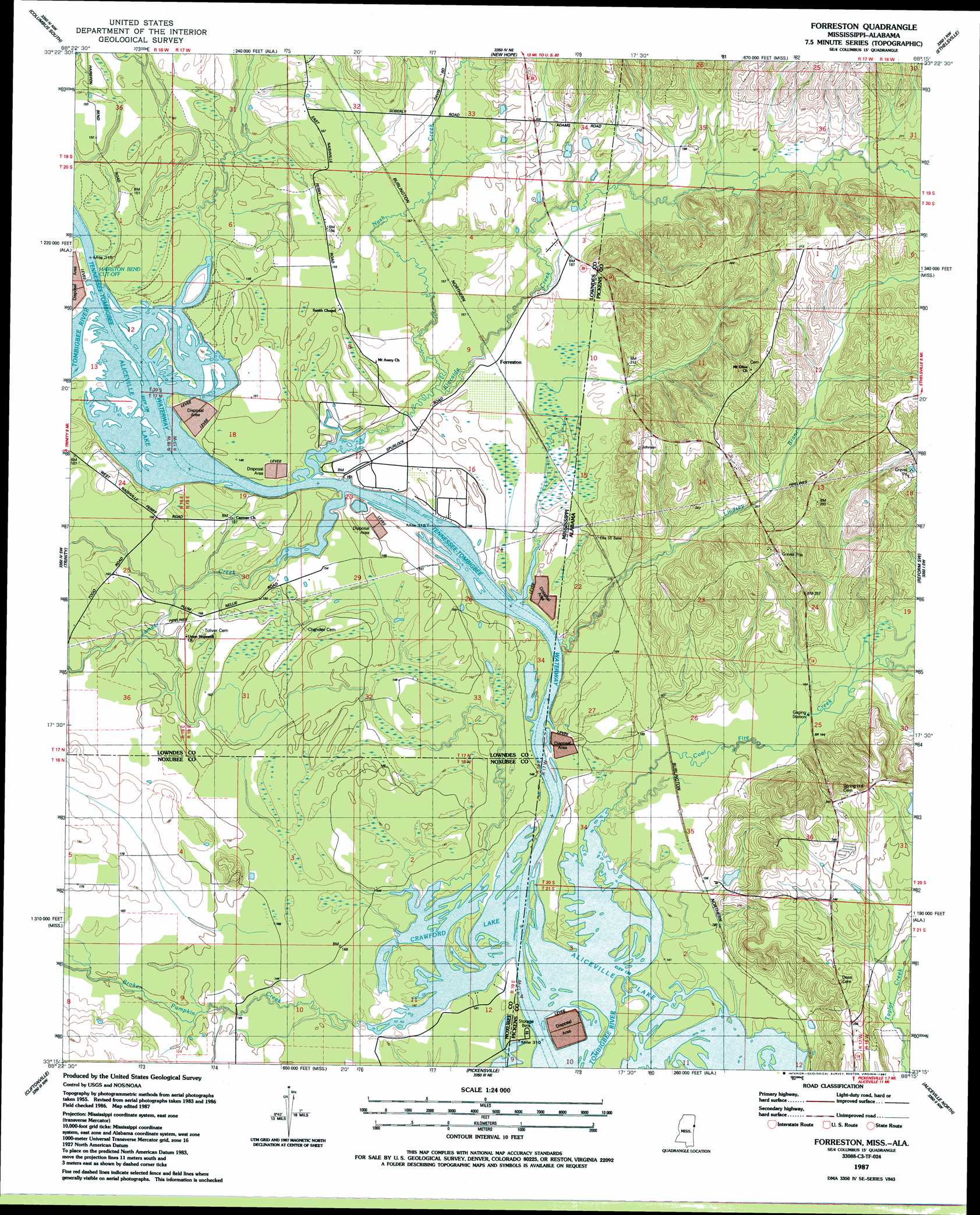
USGS Topo Quad 33088c3 - 1:24,000 scale
| Topo Map Name: | Forreston |
| USGS Topo Quad ID: | 33088c3 |
| Print Size: | ca. 21 1/4" wide x 27" high |
| Southeast Coordinates: | 33.25° N latitude / 88.25° W longitude |
| Map Center Coordinates: | 33.3125° N latitude / 88.3125° W longitude |
| U.S. States: | MS, AL |
| Filename: | o33088c3.jpg |
| Download Map JPG Image: | Forreston topo map 1:24,000 scale |
| Map Type: | Topographic |
| Topo Series: | 7.5´ |
| Map Scale: | 1:24,000 |
| Source of Map Images: | United States Geological Survey (USGS) |
| Alternate Map Versions: |
Forreston MS 1987, updated 1987 Download PDF Buy paper map Forreston MS 2012 Download PDF Buy paper map Forreston MS 2015 Download PDF Buy paper map |
1:24,000 Topo Quads surrounding Forreston
Waverly |
Columbus North |
Steens |
Fernbank |
Millport |
Bent Oak |
Columbus South |
New Hope |
Ethelsville |
Reform |
Crawford East |
Trinity |
Forreston |
Reform Sw |
Carrollton |
Brooksville |
Cliftonville |
Pickensville |
Aliceville North |
Cunningham |
Macon |
Mcleod |
Dancy |
Aliceville South |
Pleasant Ridge |
> Back to 33088a1 at 1:100,000 scale
> Back to 33088a1 at 1:250,000 scale
> Back to U.S. Topo Maps home
Forreston topo map: Gazetteer
Forreston: Bars
Bar Number 16 elevation 40m 131′Bar Number 17 elevation 40m 131′
Bar Number 18 elevation 40m 131′
Coal Fire Creek Bar elevation 41m 134′
Crawfords Bar elevation 42m 137′
Ellis Bar elevation 40m 131′
Forreston: Channels
Hairston Bend Cutoff elevation 40m 131′Forreston: Cliffs
Pettys Bluff elevation 46m 150′Union Bluff elevation 47m 154′
Forreston: Crossings
Crawfords Ferry (historical) elevation 40m 131′Nashville Ferry elevation 41m 134′
Forreston: Islands
Crawfords Island (historical) elevation 41m 134′Forreston: Lakes
Prude Lake (historical) elevation 43m 141′Forreston: Parks
James Creek Recreation Area elevation 48m 157′Forreston: Populated Places
Forreston elevation 46m 150′Nashville (historical) elevation 46m 150′
Forreston: Reservoirs
Crawford Lake elevation 41m 134′Forreston: Streams
Boyd Creek elevation 40m 131′Broken Pumpkin Creek elevation 41m 134′
Coal Fire Creek elevation 41m 134′
James Creek elevation 40m 131′
Kincaide Creek elevation 40m 131′
Kincaide Creek elevation 40m 131′
Lindsey Branch elevation 42m 137′
Nash Creek elevation 44m 144′
Woolbank Creek elevation 60m 196′
Forreston digital topo map on disk
Buy this Forreston topo map showing relief, roads, GPS coordinates and other geographical features, as a high-resolution digital map file on DVD: