Starkville Topo Map Mississippi
To zoom in, hover over the map of Starkville
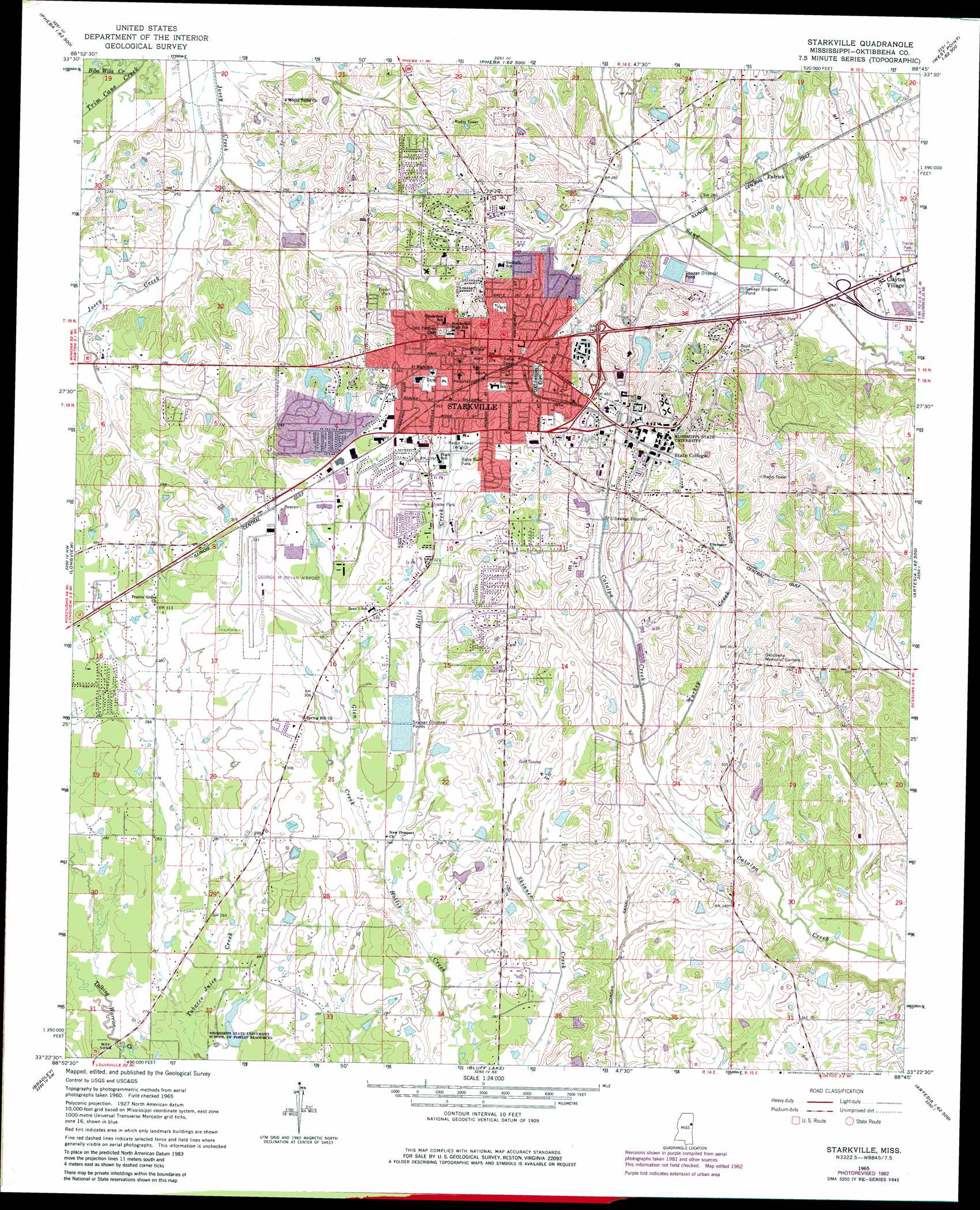
USGS Topo Quad 33088d7 - 1:24,000 scale
| Topo Map Name: | Starkville |
| USGS Topo Quad ID: | 33088d7 |
| Print Size: | ca. 21 1/4" wide x 27" high |
| Southeast Coordinates: | 33.375° N latitude / 88.75° W longitude |
| Map Center Coordinates: | 33.4375° N latitude / 88.8125° W longitude |
| U.S. State: | MS |
| Filename: | o33088d7.jpg |
| Download Map JPG Image: | Starkville topo map 1:24,000 scale |
| Map Type: | Topographic |
| Topo Series: | 7.5´ |
| Map Scale: | 1:24,000 |
| Source of Map Images: | United States Geological Survey (USGS) |
| Alternate Map Versions: |
Starkville MS 1965, updated 1966 Download PDF Buy paper map Starkville MS 1965, updated 1976 Download PDF Buy paper map Starkville MS 1965, updated 1982 Download PDF Buy paper map Starkville MS 1965, updated 1982 Download PDF Buy paper map Starkville MS 2012 Download PDF Buy paper map Starkville MS 2015 Download PDF Buy paper map |
1:24,000 Topo Quads surrounding Starkville
Mantee |
Montpelier |
Palo Alto |
Muldon |
Strong |
Maben |
Pheba |
Cedar Bluff |
West Point |
Waverly |
Double Springs |
Longview |
Starkville |
Artesia |
Bent Oak |
Sturgis |
Bradley |
Bluff Lake |
Crawford West |
Crawford East |
Louisville North |
Betheden |
Barge Lake |
Lynn Creek |
Brooksville |
> Back to 33088a1 at 1:100,000 scale
> Back to 33088a1 at 1:250,000 scale
> Back to U.S. Topo Maps home
Starkville topo map: Gazetteer
Starkville: Airports
George M Bryan Airport elevation 98m 321′Starkville: Dams
Howell Lake Dam elevation 94m 308′Howell Lake Dam elevation 88m 288′
Keller Lake Dam elevation 104m 341′
Long Lake Dam elevation 99m 324′
Lyle Lake Dam elevation 92m 301′
McHann Lake Dam elevation 99m 324′
Mississippi State College Lake Dam elevation 93m 305′
Mitchell Lake Dam elevation 79m 259′
Mitchell Lake Dam elevation 80m 262′
Oakley Lake Dam elevation 104m 341′
Page Lake Dam elevation 96m 314′
Spruell Lake Dam elevation 79m 259′
Starkille Lagoon Dam elevation 88m 288′
Starkville Lagoon Dam elevation 89m 291′
Starkville Sewage Lagoon Dam elevation 89m 291′
Starkville Sewage Lagoon Dam elevation 76m 249′
State College Sewage Lagoon Dam elevation 82m 269′
Starkville: Parks
Babe Ruth Park elevation 102m 334′Dudy Noble Field elevation 106m 347′
Jaycee Field elevation 107m 351′
McKee Park elevation 98m 321′
Moncrief Park elevation 107m 351′
Scott Field elevation 109m 357′
University Estates Community Park elevation 95m 311′
Westside Park elevation 89m 291′
Starkville: Populated Places
Academy Park elevation 100m 328′Avondale elevation 104m 341′
Bingham Estates elevation 80m 262′
Cedar Point elevation 85m 278′
Cherokee Heights elevation 93m 305′
Clayton Village elevation 80m 262′
College View elevation 110m 360′
College Vista elevation 111m 364′
Colonial Hills elevation 102m 334′
Conner Heights elevation 97m 318′
Country Club Subdivision elevation 102m 334′
Country Hills elevation 105m 344′
Country Meadows elevation 90m 295′
Country Side Estates elevation 99m 324′
Deerfield elevation 95m 311′
Didlake elevation 100m 328′
Fairfield Commons elevation 113m 370′
Fairground Subdivision elevation 103m 337′
Glendale elevation 107m 351′
Green Oaks elevation 99m 324′
Greenbriar elevation 112m 367′
Hancock Circle elevation 110m 360′
Heritage Colony elevation 92m 301′
Highland Estates elevation 89m 291′
Hillbrook elevation 108m 354′
Hillcrest elevation 103m 337′
Landers elevation 101m 331′
Magnolia Heights elevation 89m 291′
Montgomery Park elevation 97m 318′
Nashdale elevation 116m 380′
Northgate elevation 95m 311′
Northwood elevation 99m 324′
Northwood Hills elevation 96m 314′
Oktibbeha Gardens elevation 107m 351′
Page Subdivision elevation 116m 380′
Parkdale elevation 111m 364′
Patrick elevation 93m 305′
Pecan Acres elevation 103m 337′
Plantation Homes elevation 95m 311′
Pleasant Acres elevation 109m 357′
Pressly Place elevation 98m 321′
Quail Valley elevation 95m 311′
Rolling Hills elevation 94m 308′
Rosedale elevation 93m 305′
Sheely Hills elevation 99m 324′
Sherwood Forest elevation 110m 360′
Southdale elevation 113m 370′
Starkville elevation 101m 331′
Stonegate elevation 108m 354′
Sunset elevation 92m 301′
Tanglewood elevation 93m 305′
Templeton Meadows elevation 100m 328′
Timbercove elevation 110m 360′
University Estates elevation 100m 328′
University Heights elevation 110m 360′
Wellborn Subdivision elevation 104m 341′
West End elevation 104m 341′
Westwood elevation 103m 337′
Whispering Pines elevation 97m 318′
Wood Dale elevation 101m 331′
Wood Manor elevation 104m 341′
Woodland Heights elevation 95m 311′
Starkville: Post Offices
Mississippi State Post Office elevation 82m 269′Starkville: Streams
Biba Wila Creek elevation 64m 209′Glen Creek elevation 85m 278′
Turkey Creek elevation 88m 288′
Starkville digital topo map on disk
Buy this Starkville topo map showing relief, roads, GPS coordinates and other geographical features, as a high-resolution digital map file on DVD: