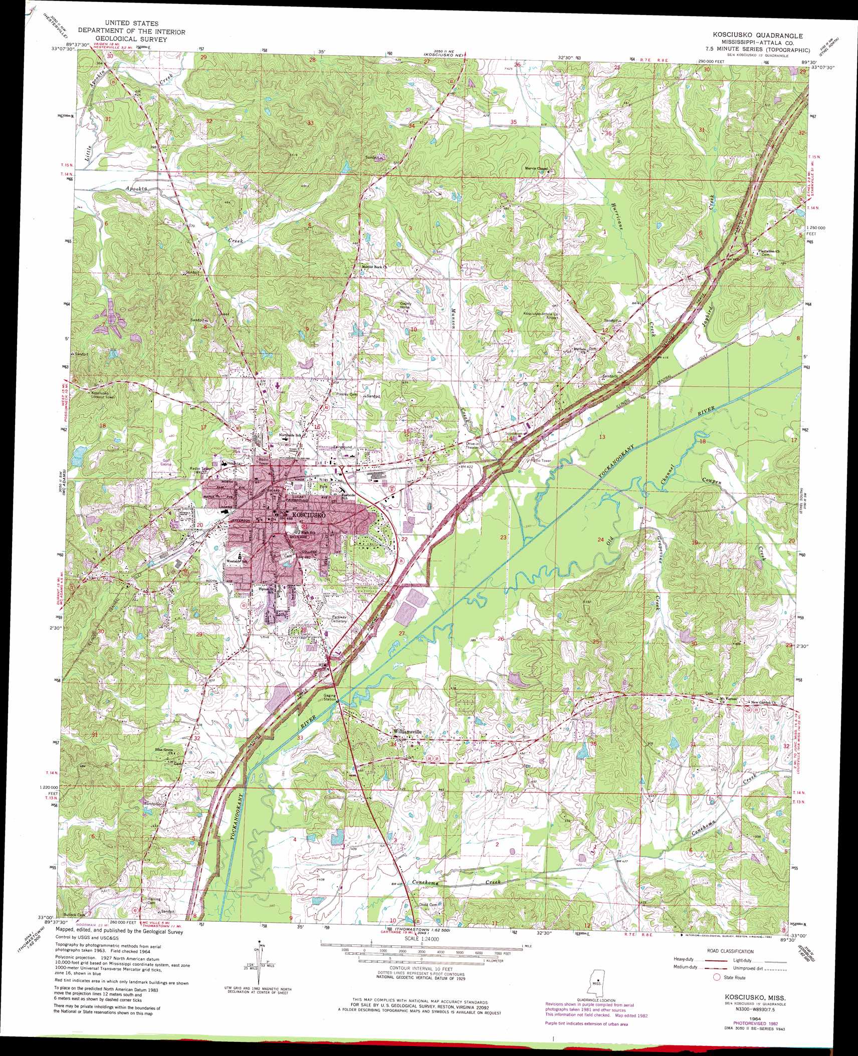
Kosciusko Topo Map Mississippi
To zoom in, hover over the map of Kosciusko
USGS Topo Quad 33089a5 - 1:24,000 scale
| Topo Map Name: | Kosciusko |
| USGS Topo Quad ID: | 33089a5 |
| Print Size: | ca. 21 1/4" wide x 27" high |
| Southeast Coordinates: | 33° N latitude / 89.5° W longitude |
| Map Center Coordinates: | 33.0625° N latitude / 89.5625° W longitude |
| U.S. State: | MS |
| Filename: | o33089a5.jpg |
| Download Map JPG Image: | Kosciusko topo map 1:24,000 scale |
| Map Type: | Topographic |
| Topo Series: | 7.5´ |
| Map Scale: | 1:24,000 |
| Source of Map Images: | United States Geological Survey (USGS) |
| Alternate Map Versions: |
Kosciusko MS 1964, updated 1965 Download PDF Buy paper map Kosciusko MS 1964, updated 1981 Download PDF Buy paper map Kosciusko MS 2012 Download PDF Buy paper map Kosciusko MS 2015 Download PDF Buy paper map |
1:24,000 Topo Quads surrounding Kosciusko
Peachahala Creek |
Vaiden |
Poplar Creek |
French Camp |
Weir |
West |
Hesterville |
Kosciusko Ne |
Ethel North |
Mccool |
Durant |
Mcadams |
Kosciusko |
Ethel South |
Ethel Se |
Newport |
Joseph |
Singleton |
Zama |
Four Corners |
Camden |
Thomastown |
Conway |
Renfroe |
Edinburg |
> Back to 33089a1 at 1:100,000 scale
> Back to 33088a1 at 1:250,000 scale
> Back to U.S. Topo Maps home
Kosciusko topo map: Gazetteer
Kosciusko: Airports
Kosciusko-Attala County Airport elevation 144m 472′Kosciusko: Bridges
Fletchers Bridge (historical) elevation 116m 380′Kosciusko: Canals
Dye Ditch elevation 119m 390′Kosciusko: Dams
Bailey Lake Dam elevation 119m 390′Brooks Lake Dam elevation 135m 442′
Kosciusko Sewage Lagoon Dam elevation 121m 396′
Kosciusko Sewage Lagoon Dam elevation 117m 383′
Lazy C Ranch Lake Dam elevation 125m 410′
Lindsey Pond Dam elevation 131m 429′
River Hills Subdivision Lake Dam elevation 123m 403′
Temple Lake Dam elevation 138m 452′
Kosciusko: Parks
Hugh Ellard Park elevation 121m 396′Landrum Field elevation 131m 429′
Niles Park elevation 130m 426′
Northside Park elevation 137m 449′
Redbud Springs Park elevation 144m 472′
Kosciusko: Populated Places
Aponaug (historical) elevation 136m 446′Dodds elevation 132m 433′
Kosciusko elevation 147m 482′
Marvins Chapel elevation 141m 462′
Munson (historical) elevation 121m 396′
Plantation elevation 141m 462′
Williamsville elevation 128m 419′
Kosciusko: Post Offices
Higgins Post Office (historical) elevation 122m 400′Kosciusko: Streams
Cowpen Creek elevation 119m 390′Grapevine Creek elevation 118m 387′
Hurricane Creek elevation 118m 387′
Jaybird Creek elevation 119m 390′
LeFlore Creek elevation 119m 390′
Munson Creek elevation 117m 383′
Old Channel Yockanookany River elevation 117m 383′
Kosciusko digital topo map on disk
Buy this Kosciusko topo map showing relief, roads, GPS coordinates and other geographical features, as a high-resolution digital map file on DVD: