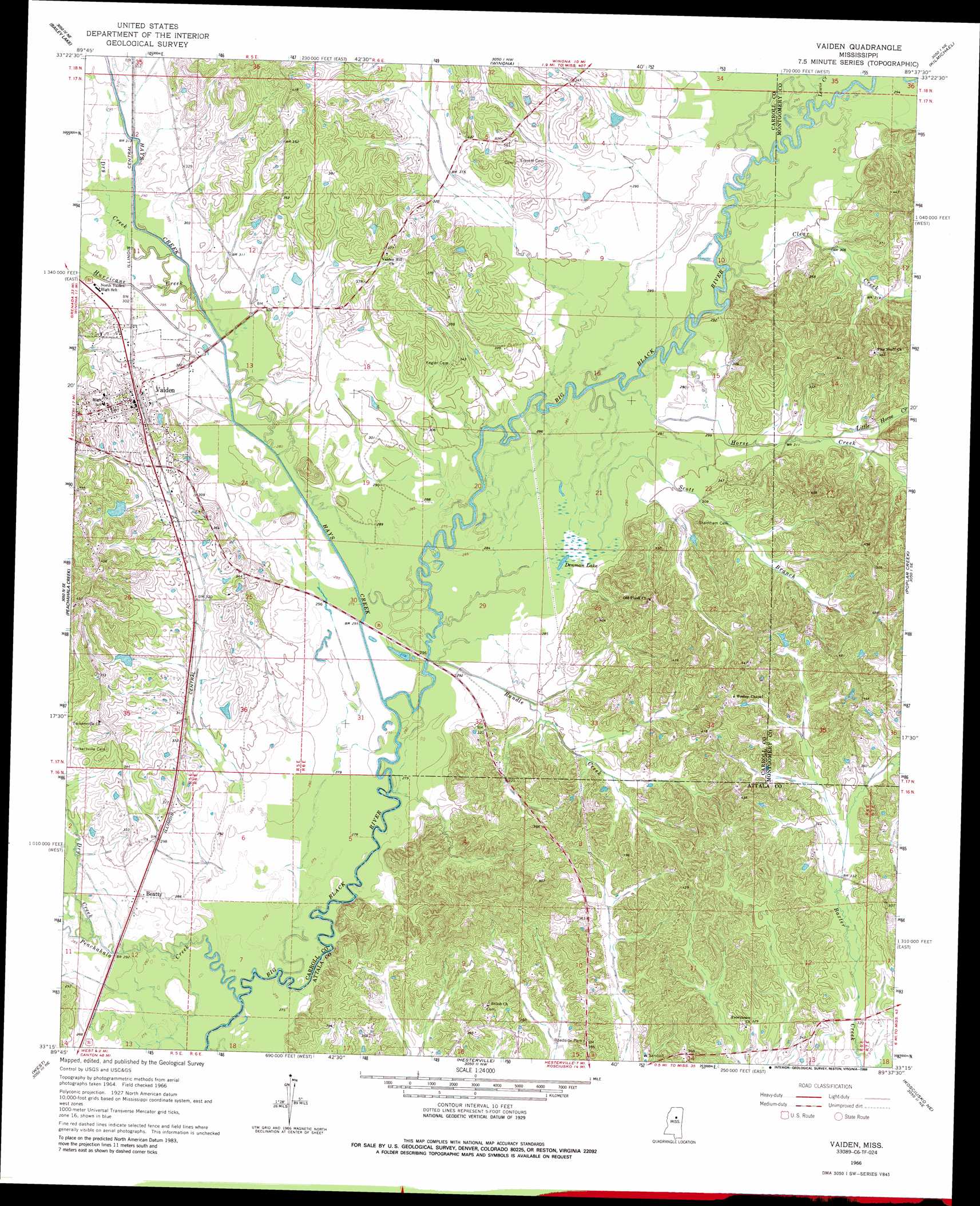
Vaiden Topo Map Mississippi
To zoom in, hover over the map of Vaiden
USGS Topo Quad 33089c6 - 1:24,000 scale
| Topo Map Name: | Vaiden |
| USGS Topo Quad ID: | 33089c6 |
| Print Size: | ca. 21 1/4" wide x 27" high |
| Southeast Coordinates: | 33.25° N latitude / 89.625° W longitude |
| Map Center Coordinates: | 33.3125° N latitude / 89.6875° W longitude |
| U.S. State: | MS |
| Filename: | o33089c6.jpg |
| Download Map JPG Image: | Vaiden topo map 1:24,000 scale |
| Map Type: | Topographic |
| Topo Series: | 7.5´ |
| Map Scale: | 1:24,000 |
| Source of Map Images: | United States Geological Survey (USGS) |
| Alternate Map Versions: |
Vaiden MS 1966, updated 1967 Download PDF Buy paper map Vaiden MS 1966, updated 1988 Download PDF Buy paper map Vaiden MS 2012 Download PDF Buy paper map Vaiden MS 2015 Download PDF Buy paper map |
1:24,000 Topo Quads surrounding Vaiden
North Carrollton |
Mccarley |
Eskridge |
Lodi |
Little Sand Creek |
Coila |
Bailey Lake |
Winona |
Kilmichael |
Stewart |
Murdock Lake |
Peachahala Creek |
Vaiden |
Poplar Creek |
French Camp |
Bowling Green |
West |
Hesterville |
Kosciusko Ne |
Ethel North |
Owens Wells |
Durant |
Mcadams |
Kosciusko |
Ethel South |
> Back to 33089a1 at 1:100,000 scale
> Back to 33088a1 at 1:250,000 scale
> Back to U.S. Topo Maps home
Vaiden topo map: Gazetteer
Vaiden: Bridges
Kaglers Bridge (historical) elevation 84m 275′Vaiden: Crossings
Denmans Ferry (historical) elevation 84m 275′Kirkwood Ferry (historical) elevation 82m 269′
Vaiden: Dams
Mississippi No Name 1 Dam elevation 109m 357′Vaiden: Lakes
Denman Lake elevation 84m 275′Vaiden: Populated Places
Beatty elevation 90m 295′Vaiden elevation 102m 334′
Vaiden: Streams
Clear Creek elevation 86m 282′Dry Creek elevation 84m 275′
Dry Creek elevation 89m 291′
Hays Creek elevation 83m 272′
Horse Creek elevation 86m 282′
Hurricane Creek elevation 87m 285′
Lewis Creek elevation 87m 285′
Little Horse Creek elevation 95m 311′
Parkers Creek elevation 88m 288′
Peachahala Creek elevation 79m 259′
Randle Creek elevation 83m 272′
Scott Branch elevation 86m 282′
Vaiden digital topo map on disk
Buy this Vaiden topo map showing relief, roads, GPS coordinates and other geographical features, as a high-resolution digital map file on DVD: