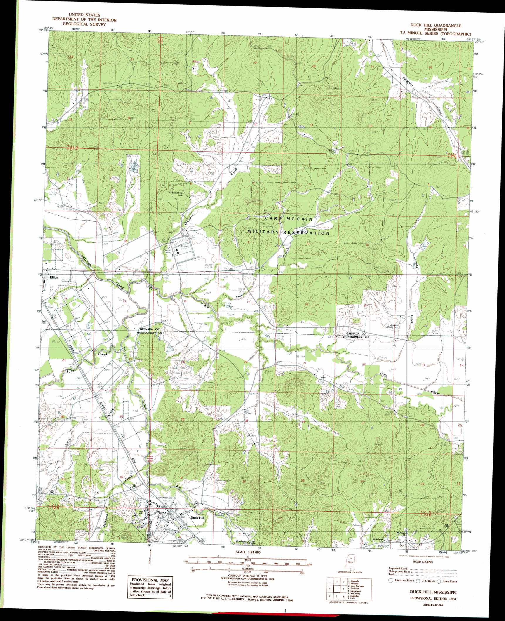
Duck Hill Topo Map Mississippi
To zoom in, hover over the map of Duck Hill
USGS Topo Quad 33089f6 - 1:24,000 scale
| Topo Map Name: | Duck Hill |
| USGS Topo Quad ID: | 33089f6 |
| Print Size: | ca. 21 1/4" wide x 27" high |
| Southeast Coordinates: | 33.625° N latitude / 89.625° W longitude |
| Map Center Coordinates: | 33.6875° N latitude / 89.6875° W longitude |
| U.S. State: | MS |
| Filename: | o33089f6.jpg |
| Download Map JPG Image: | Duck Hill topo map 1:24,000 scale |
| Map Type: | Topographic |
| Topo Series: | 7.5´ |
| Map Scale: | 1:24,000 |
| Source of Map Images: | United States Geological Survey (USGS) |
| Alternate Map Versions: |
Duck Hill MS 1983, updated 1983 Download PDF Buy paper map Duck Hill MS 1983, updated 1983 Download PDF Buy paper map Duck Hill MS 2012 Download PDF Buy paper map Duck Hill MS 2015 Download PDF Buy paper map |
1:24,000 Topo Quads surrounding Duck Hill
Tillatoba |
Scobey |
Coffeeville |
Benwood |
Skuna |
Holcomb |
Grenada |
Kincaid |
Gore Springs |
Big Creek |
Jefferson |
Tie Plant |
Duck Hill |
Sweatman |
Cadaretta |
North Carrollton |
Mccarley |
Eskridge |
Lodi |
Little Sand Creek |
Coila |
Bailey Lake |
Winona |
Kilmichael |
Stewart |
> Back to 33089e1 at 1:100,000 scale
> Back to 33088a1 at 1:250,000 scale
> Back to U.S. Topo Maps home
Duck Hill topo map: Gazetteer
Duck Hill: Dams
Bogue Watershed Y-30-108 Dam elevation 90m 295′Duck Hill: Populated Places
Duck Hill elevation 78m 255′Elliott elevation 69m 226′
Duck Hill: Streams
Big Bogue elevation 59m 193′Bogue Creek elevation 60m 196′
Campbell Creek elevation 70m 229′
Crowder Creek elevation 61m 200′
Epison Branch elevation 61m 200′
Jackson Creek elevation 67m 219′
Little Bogue elevation 59m 193′
Sykes Creek elevation 62m 203′
Wilkins Creek elevation 62m 203′
Worsham Creek elevation 73m 239′
Duck Hill digital topo map on disk
Buy this Duck Hill topo map showing relief, roads, GPS coordinates and other geographical features, as a high-resolution digital map file on DVD: