Howard Topo Map Mississippi
To zoom in, hover over the map of Howard
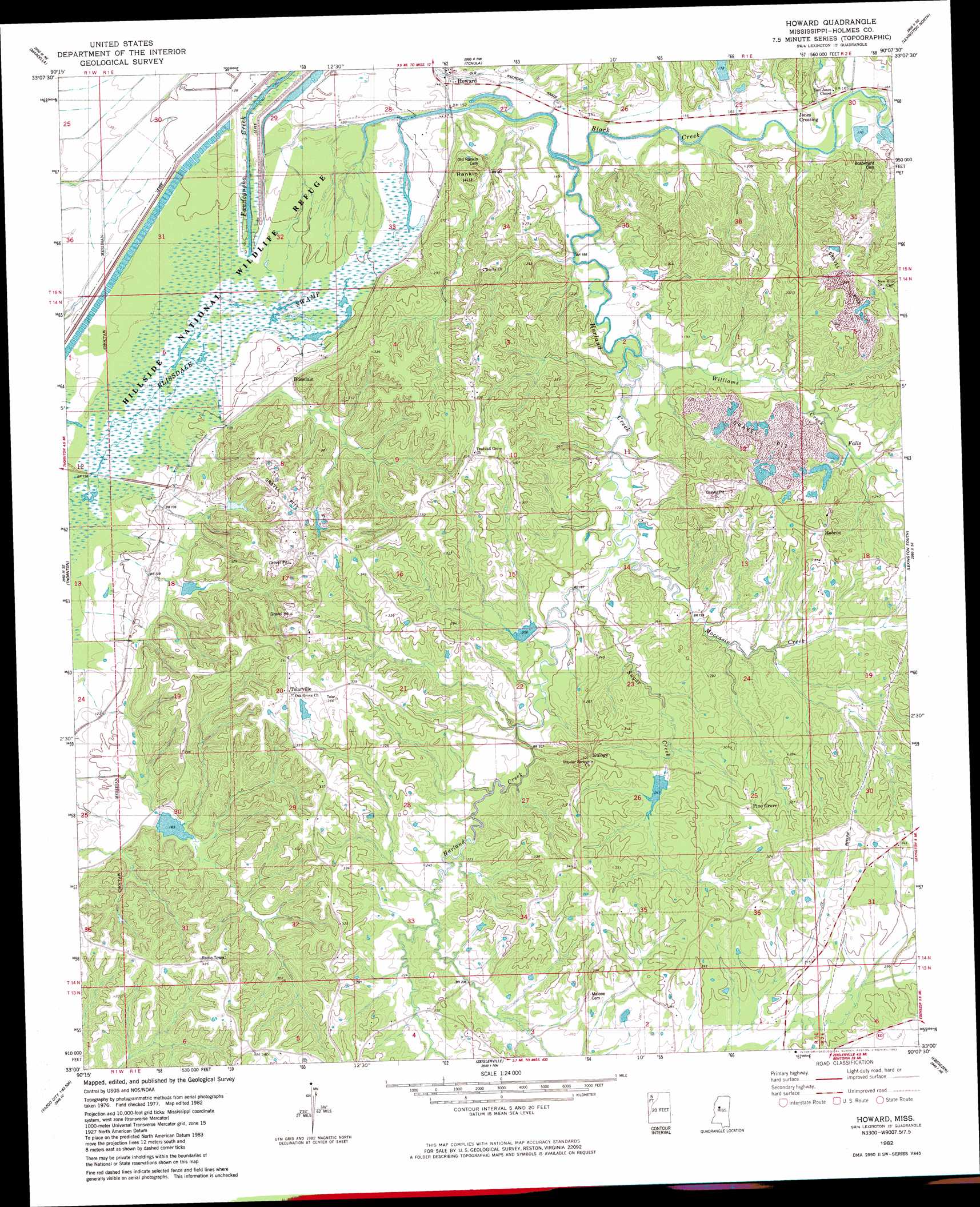
USGS Topo Quad 33090a2 - 1:24,000 scale
| Topo Map Name: | Howard |
| USGS Topo Quad ID: | 33090a2 |
| Print Size: | ca. 21 1/4" wide x 27" high |
| Southeast Coordinates: | 33° N latitude / 90.125° W longitude |
| Map Center Coordinates: | 33.0625° N latitude / 90.1875° W longitude |
| U.S. State: | MS |
| Filename: | o33090a2.jpg |
| Download Map JPG Image: | Howard topo map 1:24,000 scale |
| Map Type: | Topographic |
| Topo Series: | 7.5´ |
| Map Scale: | 1:24,000 |
| Source of Map Images: | United States Geological Survey (USGS) |
| Alternate Map Versions: |
Howard MS 1982, updated 1982 Download PDF Buy paper map Howard MS 2012 Download PDF Buy paper map Howard MS 2015 Download PDF Buy paper map |
1:24,000 Topo Quads surrounding Howard
Swiftown |
Montgomery |
Cruger |
Black Hawk |
Murdock Lake |
Belzoni |
Marcella |
Tchula |
Lexington North |
Bowling Green |
Silver City |
Thornton |
Howard |
Lexington South |
Owens Wells |
Carter |
Eden |
Zeiglerville |
Ebenezer |
Goodman |
Yazoo City |
Benton |
Linwood |
Vaughan |
Cameron |
> Back to 33090a1 at 1:100,000 scale
> Back to 33090a1 at 1:250,000 scale
> Back to U.S. Topo Maps home
Howard topo map: Gazetteer
Howard: Dams
Black Watershed Y-36-39 Dam elevation 75m 246′Black Watershed Y-36-40 Dam elevation 60m 196′
Black Watershed Y-36-43 Dam elevation 73m 239′
Black Watershed Y-36-48 Dam elevation 43m 141′
Black Watershed Y-36-49 Dam elevation 43m 141′
Black Watershed Y-36-50 Dam elevation 47m 154′
MacMorrow-Hammett Lake Dam elevation 59m 193′
Mississippi No Name 24 Dam elevation 50m 164′
Howard: Populated Places
Blissdale elevation 40m 131′Eulogy elevation 93m 305′
Howard elevation 42m 137′
Jones Crossing elevation 51m 167′
Pine Grove elevation 106m 347′
Tolarville elevation 107m 351′
Howard: Streams
Black Creek elevation 40m 131′Harland Creek elevation 43m 141′
Moccasin Creek elevation 51m 167′
Sugar Creek elevation 56m 183′
Williams Creek elevation 47m 154′
Howard digital topo map on disk
Buy this Howard topo map showing relief, roads, GPS coordinates and other geographical features, as a high-resolution digital map file on DVD: