Inverness Topo Map Mississippi
To zoom in, hover over the map of Inverness
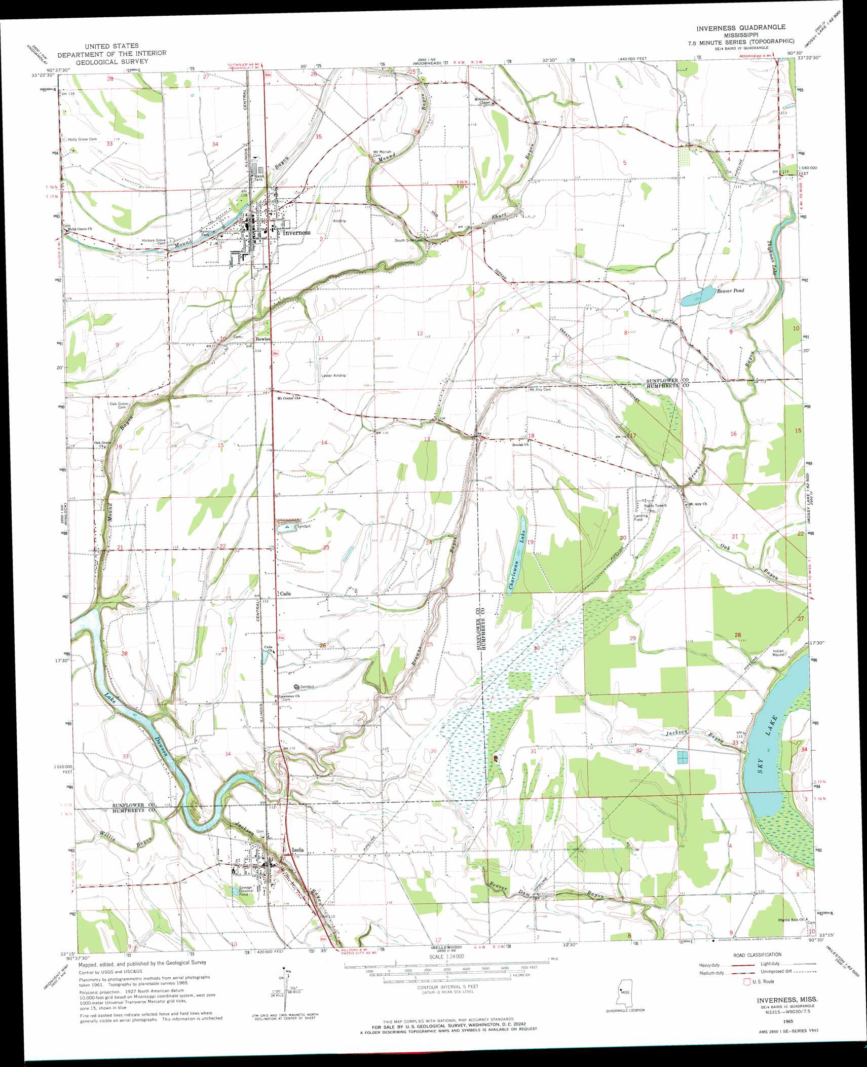
USGS Topo Quad 33090c5 - 1:24,000 scale
| Topo Map Name: | Inverness |
| USGS Topo Quad ID: | 33090c5 |
| Print Size: | ca. 21 1/4" wide x 27" high |
| Southeast Coordinates: | 33.25° N latitude / 90.5° W longitude |
| Map Center Coordinates: | 33.3125° N latitude / 90.5625° W longitude |
| U.S. State: | MS |
| Filename: | o33090c5.jpg |
| Download Map JPG Image: | Inverness topo map 1:24,000 scale |
| Map Type: | Topographic |
| Topo Series: | 7.5´ |
| Map Scale: | 1:24,000 |
| Source of Map Images: | United States Geological Survey (USGS) |
| Alternate Map Versions: |
Inverness MS 1965, updated 1966 Download PDF Buy paper map Inverness MS 2012 Download PDF Buy paper map Inverness MS 2015 Download PDF Buy paper map |
1:24,000 Topo Quads surrounding Inverness
Shaw |
Boyer |
Sunflower |
Bear Gut Bayou |
Shellmound |
Holly Ridge |
Indianola |
Moorhead |
Colony Town |
Itta Bena |
Tribbett |
Kinlock |
Inverness |
Swiftown |
Montgomery |
Hollandale |
Midnight Nw |
Bellewood |
Belzoni |
Marcella |
Delta City |
Richey |
Midnight |
Silver City |
Thornton |
> Back to 33090a1 at 1:100,000 scale
> Back to 33090a1 at 1:250,000 scale
> Back to U.S. Topo Maps home
Inverness topo map: Gazetteer
Inverness: Airports
Lester Field elevation 35m 114′Montgomery Airport elevation 36m 118′
Newell Flying Service Airport elevation 35m 114′
Inverness: Dams
Charles Rowland Lake Dam elevation 34m 111′Clark Pond Dam elevation 33m 108′
Crawford Brothers Pond Dam elevation 34m 111′
Duke Lake Dam elevation 34m 111′
Duthu Lake Dam elevation 31m 101′
H B Rowland Pond Dam elevation 32m 104′
Myers Lake Dam elevation 33m 108′
Inverness: Lakes
Beaver Pond elevation 33m 108′Charlewan Lake elevation 33m 108′
Sky Lake elevation 29m 95′
Thighman Lake elevation 32m 104′
Inverness: Populated Places
Bowles elevation 35m 114′Caile elevation 35m 114′
Inverness elevation 36m 118′
Isola elevation 35m 114′
Milroy elevation 34m 111′
Southside elevation 33m 108′
Inverness: Streams
Browns Bayou elevation 28m 91′Jackson Bayou elevation 27m 88′
Jackson Bayou elevation 29m 95′
Mound Bayou elevation 27m 88′
Oak Bayou elevation 32m 104′
Short Bayou elevation 32m 104′
Willis Bayou elevation 27m 88′
Inverness digital topo map on disk
Buy this Inverness topo map showing relief, roads, GPS coordinates and other geographical features, as a high-resolution digital map file on DVD: