Browning Topo Map Mississippi
To zoom in, hover over the map of Browning
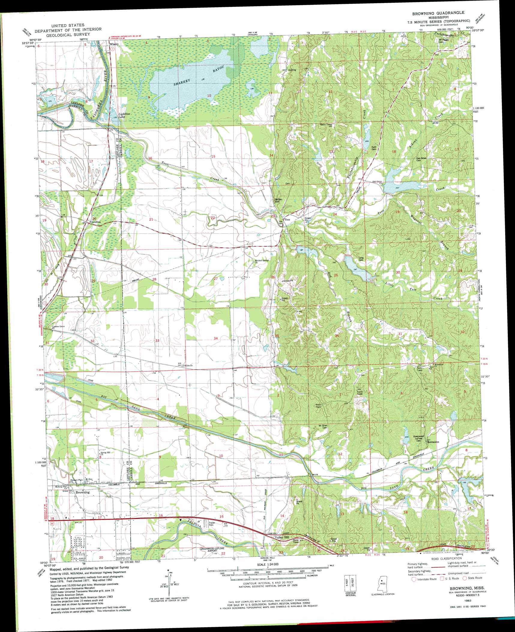
USGS Topo Quad 33090e1 - 1:24,000 scale
| Topo Map Name: | Browning |
| USGS Topo Quad ID: | 33090e1 |
| Print Size: | ca. 21 1/4" wide x 27" high |
| Southeast Coordinates: | 33.5° N latitude / 90° W longitude |
| Map Center Coordinates: | 33.5625° N latitude / 90.0625° W longitude |
| U.S. State: | MS |
| Filename: | o33090e1.jpg |
| Download Map JPG Image: | Browning topo map 1:24,000 scale |
| Map Type: | Topographic |
| Topo Series: | 7.5´ |
| Map Scale: | 1:24,000 |
| Source of Map Images: | United States Geological Survey (USGS) |
| Alternate Map Versions: |
Greenwood SE MS 1974, updated 1975 Download PDF Buy paper map Browning MS 1982, updated 1982 Download PDF Buy paper map Browning MS 2012 Download PDF Buy paper map Browning MS 2015 Download PDF Buy paper map |
1:24,000 Topo Quads surrounding Browning
Glendora |
Philipp |
Cascilla |
Holcomb |
Grenada |
Schlater |
Money |
Avalon |
Jefferson |
Tie Plant |
Shellmound |
Greenwood |
Browning |
North Carrollton |
Mccarley |
Itta Bena |
Sidon |
Gravel Hill |
Coila |
Bailey Lake |
Montgomery |
Cruger |
Black Hawk |
Murdock Lake |
Peachahala Creek |
> Back to 33090e1 at 1:100,000 scale
> Back to 33090a1 at 1:250,000 scale
> Back to U.S. Topo Maps home
Browning topo map: Gazetteer
Browning: Dams
Big Sand Creek Structure Y-32-25 Dam elevation 59m 193′Big Sand Creek Structure Y-32-27 Dam elevation 83m 272′
Big Sand Watershed Y-32-14 Dam elevation 61m 200′
Big Sand Watershed Y-32-15 Dam elevation 58m 190′
Big Sand Watershed Y-32-16 Dam elevation 61m 200′
Big Sand Watershed Y-32-17 Dam elevation 61m 200′
Big Sand Watershed Y-32-18 Dam elevation 76m 249′
Big Sand Watershed Y-32-19 Dam elevation 69m 226′
Big Sand Watershed Y-32-29 Dam elevation 70m 229′
Big Sand Watershed Y-32-7 Dam elevation 63m 206′
Browning: Guts
Sharkey Bayou elevation 32m 104′Browning: Lakes
Lightline Lake elevation 41m 134′Long Lake elevation 38m 124′
Browning: Populated Places
Bright Corner elevation 38m 124′Browning elevation 39m 127′
Crenfree elevation 39m 127′
Malmaison elevation 56m 183′
Teoc elevation 47m 154′
Valley Hill elevation 51m 167′
Whaley elevation 40m 131′
Browning: Streams
Aikens Creek elevation 61m 200′Bucksnubby Branch elevation 67m 219′
Dog Branch elevation 50m 164′
Little Teoc Creek elevation 49m 160′
Puchshinnubie Creek elevation 49m 160′
Teoc Creek elevation 38m 124′
Wagoner Branch elevation 62m 203′
Browning digital topo map on disk
Buy this Browning topo map showing relief, roads, GPS coordinates and other geographical features, as a high-resolution digital map file on DVD: