Readland Topo Map Arkansas
To zoom in, hover over the map of Readland
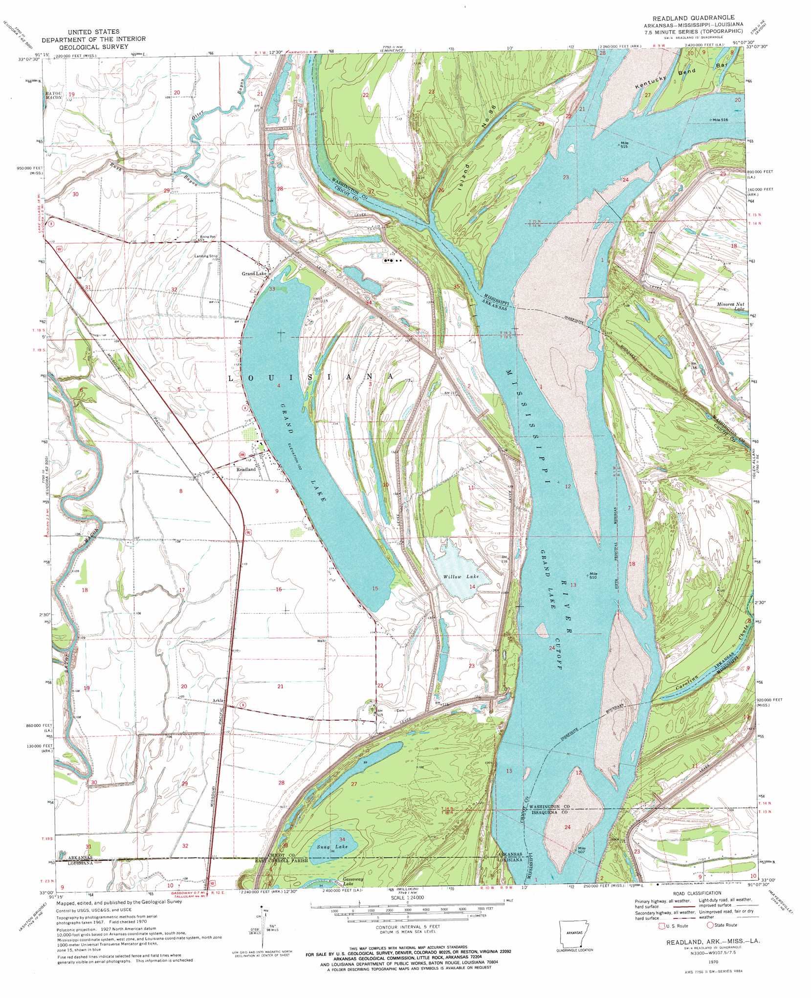
USGS Topo Quad 33091a2 - 1:24,000 scale
| Topo Map Name: | Readland |
| USGS Topo Quad ID: | 33091a2 |
| Print Size: | ca. 21 1/4" wide x 27" high |
| Southeast Coordinates: | 33° N latitude / 91.125° W longitude |
| Map Center Coordinates: | 33.0625° N latitude / 91.1875° W longitude |
| U.S. States: | AR, LA, MS |
| Filename: | o33091a2.jpg |
| Download Map JPG Image: | Readland topo map 1:24,000 scale |
| Map Type: | Topographic |
| Topo Series: | 7.5´ |
| Map Scale: | 1:24,000 |
| Source of Map Images: | United States Geological Survey (USGS) |
| Alternate Map Versions: |
Readland AR 1970, updated 1972 Download PDF Buy paper map Readland AR 2011 Download PDF Buy paper map Readland AR 2014 Download PDF Buy paper map |
1:24,000 Topo Quads surrounding Readland
Montrose |
Lake Village |
Red Leaf |
Wayside |
Arcola |
Eudora Nw |
Eudora North |
Eminence |
Avon |
Swan Lake Nw |
Empire |
Eudora South |
Readland |
Glen Allan |
Percy |
Fiske |
Kilbourne |
Millikin |
Mayersville |
Rolling Fork West |
Oak Grove |
Baxter Bayou |
Lake Providence |
Whiting Bayou |
Cary |
> Back to 33091a1 at 1:100,000 scale
> Back to 33090a1 at 1:250,000 scale
> Back to U.S. Topo Maps home
Readland topo map: Gazetteer
Readland: Areas
Island Number 89 elevation 33m 108′Readland: Bars
Carolina Bar elevation 24m 78′Readland: Bends
Grand Lake Cutoff elevation 26m 85′Matthews Bend elevation 27m 88′
Readland: Channels
Cracraft Chute elevation 25m 82′Worthington Cutoff elevation 25m 82′
Readland: Dams
Ball Lake Dam Number One elevation 32m 104′Readland: Guts
Rush Bayou elevation 30m 98′Readland: Islands
Cracraft Towhead elevation 36m 118′Island Number Eightyeight elevation 37m 121′
Readland: Lakes
Grand Lake elevation 31m 101′Snag Lake elevation 24m 78′
Snag Lake elevation 29m 95′
Willow Lake elevation 29m 95′
Readland: Levees
Cracraft Dikes elevation 25m 82′Cracraft Lower Dikes elevation 25m 82′
Cracraft Revetment elevation 31m 101′
Readland: Populated Places
Grand Lake elevation 35m 114′Readland elevation 34m 111′
Sterling (historical) elevation 40m 131′
Readland: Post Offices
Readland Post Office (historical) elevation 34m 111′Readland: Reservoirs
Ball Lake elevation 32m 104′Readland digital topo map on disk
Buy this Readland topo map showing relief, roads, GPS coordinates and other geographical features, as a high-resolution digital map file on DVD: