Greenville Topo Map Mississippi
To zoom in, hover over the map of Greenville
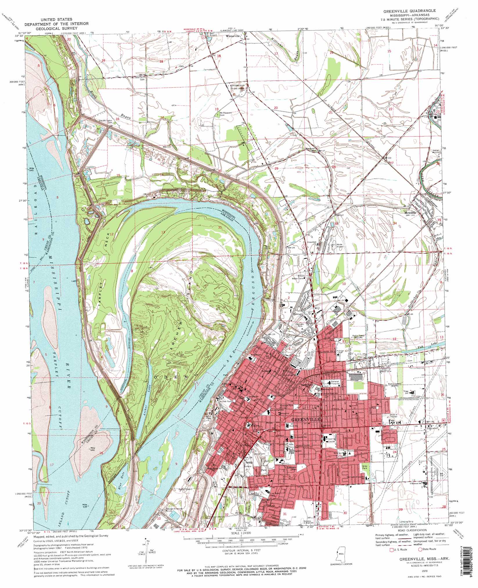
USGS Topo Quad 33091d1 - 1:24,000 scale
| Topo Map Name: | Greenville |
| USGS Topo Quad ID: | 33091d1 |
| Print Size: | ca. 21 1/4" wide x 27" high |
| Southeast Coordinates: | 33.375° N latitude / 91° W longitude |
| Map Center Coordinates: | 33.4375° N latitude / 91.0625° W longitude |
| U.S. States: | MS, AR |
| Filename: | o33091d1.jpg |
| Download Map JPG Image: | Greenville topo map 1:24,000 scale |
| Map Type: | Topographic |
| Topo Series: | 7.5´ |
| Map Scale: | 1:24,000 |
| Source of Map Images: | United States Geological Survey (USGS) |
| Alternate Map Versions: |
Greenville MS 1970, updated 1972 Download PDF Buy paper map Greenville MS 1970, updated 1972 Download PDF Buy paper map Greenville MS 2011 Download PDF Buy paper map Greenville MS 2012 Download PDF Buy paper map Greenville MS 2015 Download PDF Buy paper map |
1:24,000 Topo Quads surrounding Greenville
Mcarthur |
Catfish Point |
Benoit |
Lobdell |
Skene |
Halley |
Arkansas City |
Scott |
Stringtown |
Shaw |
Macon Lake |
Luna |
Greenville |
Leland |
Holly Ridge |
Lake Village |
Red Leaf |
Wayside |
Arcola |
Tribbett |
Eudora North |
Eminence |
Avon |
Swan Lake Nw |
Hollandale |
> Back to 33091a1 at 1:100,000 scale
> Back to 33090a1 at 1:250,000 scale
> Back to U.S. Topo Maps home
Greenville topo map: Gazetteer
Greenville: Airports
Abide Airport elevation 38m 124′Fairfield Airport elevation 35m 114′
Greenville: Bends
Bachelor Bend elevation 34m 111′Miller Bend elevation 33m 108′
Greenville: Capes
Point Chicot elevation 37m 121′Tarpley Neck elevation 33m 108′
Greenville: Channels
Tarpley Cutoff elevation 30m 98′Greenville: Islands
Archer Island elevation 40m 131′Greenville: Lakes
Archer Lake elevation 35m 114′Blue Hole Lake elevation 32m 104′
Lake Ferguson elevation 29m 95′
Greenville: Levees
Leland Cutoff Revetment elevation 38m 124′Greenville: Parks
Archer Park elevation 39m 127′Bryan Park elevation 37m 121′
Emmett Thomas Playground elevation 36m 118′
Fanny Arnold Park elevation 38m 124′
Frisbee Park elevation 37m 121′
Gray Park elevation 36m 118′
Greenway Park elevation 37m 121′
Number Four Playground elevation 38m 124′
Rounds Park elevation 38m 124′
Strange Park elevation 38m 124′
Winterville State Park elevation 41m 134′
Greenville: Populated Places
Ashwood (historical) elevation 30m 98′Brighton elevation 40m 131′
Greenville elevation 40m 131′
Hunt elevation 39m 127′
Metcalfe elevation 38m 124′
Paducah (historical) elevation 36m 118′
Greenville: Post Offices
Crossroads Post Office elevation 35m 114′Greenville Post Office elevation 40m 131′
Greenville: Streams
Black Bayou elevation 36m 118′Horseshoe Bayou elevation 34m 111′
Greenville digital topo map on disk
Buy this Greenville topo map showing relief, roads, GPS coordinates and other geographical features, as a high-resolution digital map file on DVD: