Arkansas City Topo Map Arkansas
To zoom in, hover over the map of Arkansas City
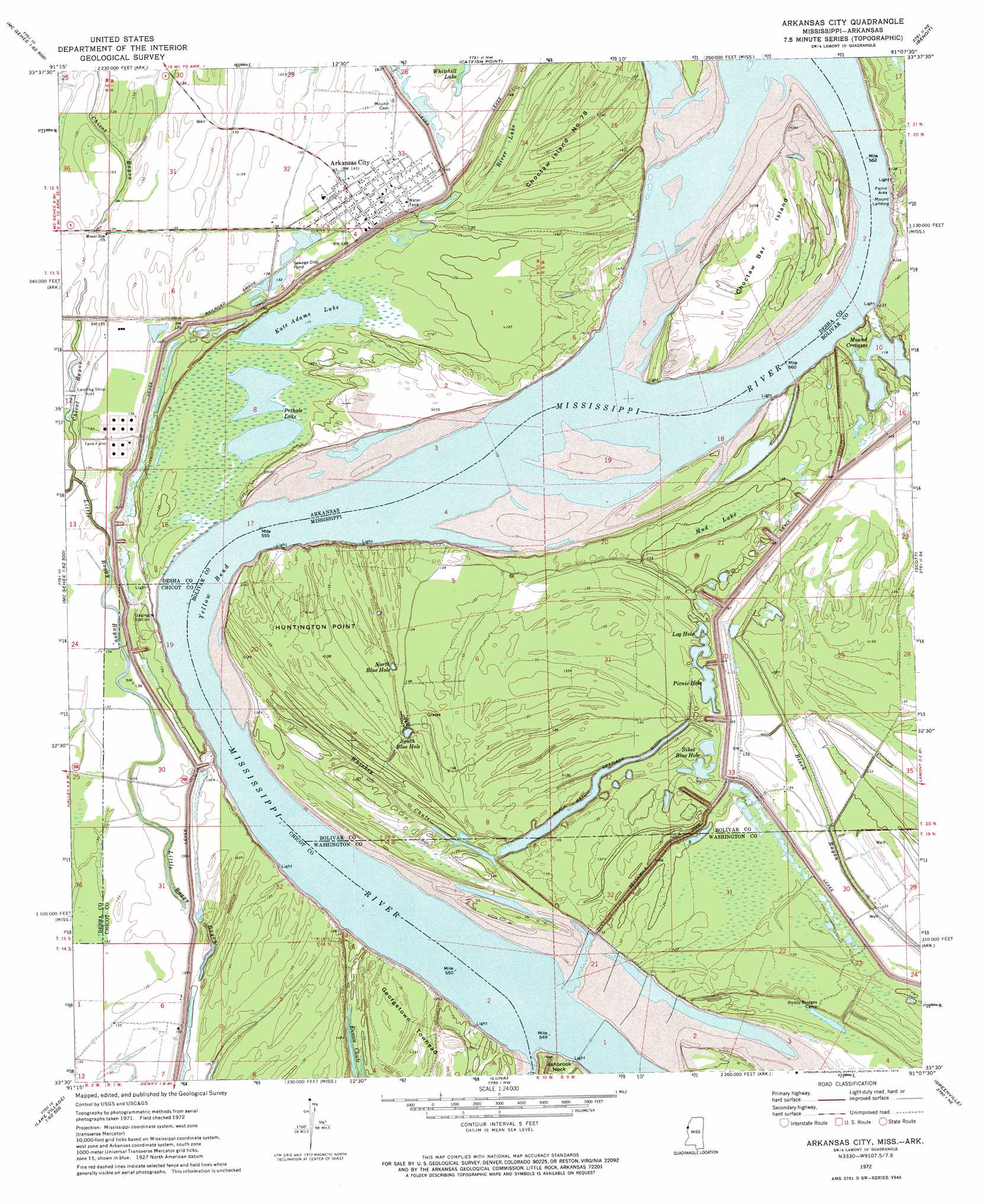
USGS Topo Quad 33091e2 - 1:24,000 scale
| Topo Map Name: | Arkansas City |
| USGS Topo Quad ID: | 33091e2 |
| Print Size: | ca. 21 1/4" wide x 27" high |
| Southeast Coordinates: | 33.5° N latitude / 91.125° W longitude |
| Map Center Coordinates: | 33.5625° N latitude / 91.1875° W longitude |
| U.S. States: | AR, MS |
| Filename: | o33091e2.jpg |
| Download Map JPG Image: | Arkansas City topo map 1:24,000 scale |
| Map Type: | Topographic |
| Topo Series: | 7.5´ |
| Map Scale: | 1:24,000 |
| Source of Map Images: | United States Geological Survey (USGS) |
| Alternate Map Versions: |
Arkansas City AR 1972, updated 1974 Download PDF Buy paper map Arkansas City AR 2011 Download PDF Buy paper map Arkansas City AR 2014 Download PDF Buy paper map |
1:24,000 Topo Quads surrounding Arkansas City
Winchester |
Kelso |
Lake Cheatham |
Rosedale |
Beulah |
Mcgehee North |
Mcarthur |
Catfish Point |
Benoit |
Lobdell |
Mcgehee South |
Halley |
Arkansas City |
Scott |
Stringtown |
Jerome |
Macon Lake |
Luna |
Greenville |
Leland |
Montrose |
Lake Village |
Red Leaf |
Wayside |
Arcola |
> Back to 33091e1 at 1:100,000 scale
> Back to 33090a1 at 1:250,000 scale
> Back to U.S. Topo Maps home
Arkansas City topo map: Gazetteer
Arkansas City: Areas
Island Number 80 elevation 41m 134′Arkansas City: Bars
Huntington Bar elevation 33m 108′Arkansas City: Bends
Choctaw Bend elevation 35m 114′Georgetown Bend elevation 31m 101′
Yellow Bend elevation 32m 104′
Arkansas City: Canals
Black Bayou Drainage Ditch elevation 35m 114′Arkansas City: Capes
Huntington Point elevation 40m 131′Arkansas City: Guts
Chicot Bayou elevation 37m 121′Little Boggy Bayou elevation 42m 137′
Whiskey Chute elevation 36m 118′
Arkansas City: Islands
Choctaw Bar Island elevation 40m 131′Choctaw Island Number 78 elevation 40m 131′
Georgetown Towhead elevation 43m 141′
Arkansas City: Lakes
Kate Adams Lake elevation 31m 101′Log Hole elevation 37m 121′
Mound Crevasse elevation 35m 114′
North Blue Hole elevation 38m 124′
Picnic Hole elevation 37m 121′
Pothole Lake elevation 34m 111′
Sikes Blue Hole elevation 39m 127′
South Blue Hole elevation 36m 118′
Arkansas City: Levees
Arkansas City Yellow Bend Revetment elevation 36m 118′Choctaw Revetment elevation 32m 104′
Huntington Point Revetment elevation 35m 114′
Pair O' Dice Revetment elevation 37m 121′
Sevenmile Dike elevation 48m 157′
Arkansas City: Populated Places
Arkansas City elevation 41m 134′Mound Landing elevation 41m 134′
Port Anderson (historical) elevation 31m 101′
Arkansas City: Swamps
Mud Lake elevation 38m 124′River Lake elevation 40m 131′
Arkansas City digital topo map on disk
Buy this Arkansas City topo map showing relief, roads, GPS coordinates and other geographical features, as a high-resolution digital map file on DVD: