Felsenthal Dam Topo Map Arkansas
To zoom in, hover over the map of Felsenthal Dam
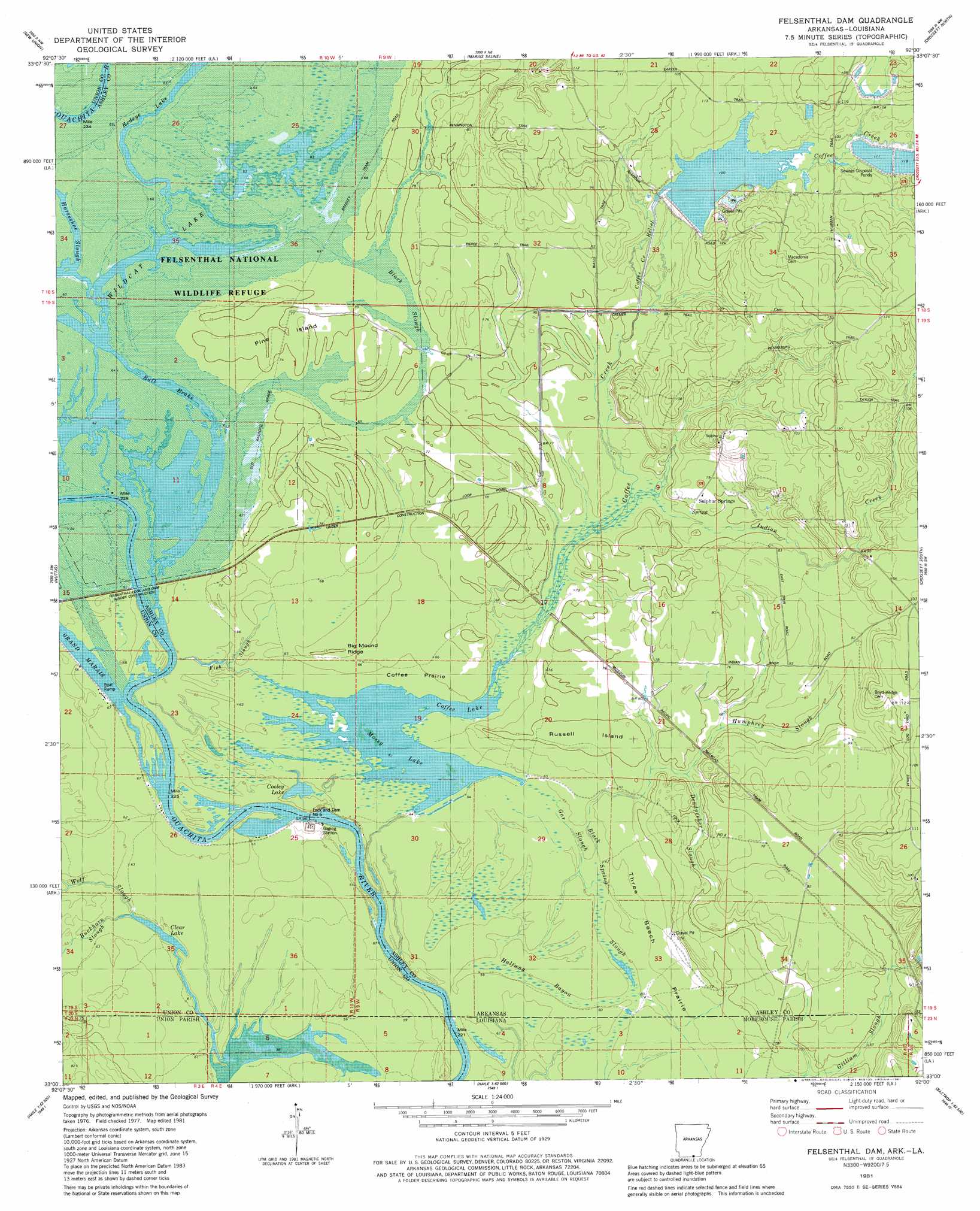
USGS Topo Quad 33092a1 - 1:24,000 scale
| Topo Map Name: | Felsenthal Dam |
| USGS Topo Quad ID: | 33092a1 |
| Print Size: | ca. 21 1/4" wide x 27" high |
| Southeast Coordinates: | 33° N latitude / 92° W longitude |
| Map Center Coordinates: | 33.0625° N latitude / 92.0625° W longitude |
| U.S. States: | AR, LA |
| Filename: | o33092a1.jpg |
| Download Map JPG Image: | Felsenthal Dam topo map 1:24,000 scale |
| Map Type: | Topographic |
| Topo Series: | 7.5´ |
| Map Scale: | 1:24,000 |
| Source of Map Images: | United States Geological Survey (USGS) |
| Alternate Map Versions: |
Felsenthal Dam AR 1981, updated 1981 Download PDF Buy paper map Felsenthal Dam AR 2011 Download PDF Buy paper map Felsenthal Dam AR 2014 Download PDF Buy paper map |
1:24,000 Topo Quads surrounding Felsenthal Dam
Moro Bay |
Marsden |
Vick |
Milo |
Fountain Hill |
New London |
New Union |
Marais Saline |
Crossett North |
Hamburg |
Strong |
Huttig |
Felsenthal Dam |
Crossett South |
Berlin |
Marion West |
Marion East |
Fish Lake |
Beckman |
Twin Oaks |
De Loutre |
Haille |
Harrell Lake |
Bastrop |
Mer Rouge |
> Back to 33092a1 at 1:100,000 scale
> Back to 33092a1 at 1:250,000 scale
> Back to U.S. Topo Maps home
Felsenthal Dam topo map: Gazetteer
Felsenthal Dam: Bars
Rolands Raft elevation 19m 62′Felsenthal Dam: Canals
Coffee Creek Relief elevation 27m 88′Felsenthal Dam: Dams
Felsenthal Lock and Dam elevation 17m 55′Lock and Dam Number 6 elevation 17m 55′
Mill Pond Dam elevation 26m 85′
Felsenthal Dam: Flats
Coffee Prairie elevation 20m 65′Russell Island elevation 24m 78′
Three Beech Prairie elevation 21m 68′
Three Beech Prairie elevation 23m 75′
Felsenthal Dam: Guts
Black Slough elevation 21m 68′Black Spring Slough elevation 20m 65′
Deadpecker Slough elevation 22m 72′
Deadpecker Slough elevation 24m 78′
Fish Slough elevation 19m 62′
Gar Slough elevation 20m 65′
Gilliam Slough elevation 25m 82′
Horseshoe Slough elevation 22m 72′
Humphrey Slough elevation 23m 75′
Felsenthal Dam: Islands
Pine Island elevation 22m 72′Felsenthal Dam: Lakes
Clear Lake elevation 18m 59′Coffee Lake elevation 17m 55′
Cooley Lake elevation 17m 55′
Mossy Lake elevation 20m 65′
Redeye Lake elevation 21m 68′
Wildcat Lake elevation 20m 65′
Felsenthal Dam: Populated Places
Sulphur Springs elevation 24m 78′Venice elevation 26m 85′
Felsenthal Dam: Reservoirs
Mill Pond elevation 26m 85′Ouachita River Reservoir elevation 21m 68′
Felsenthal Dam: Ridges
Big Mound Ridge elevation 25m 82′Felsenthal Dam: Springs
Sulphur Spring elevation 22m 72′Felsenthal Dam: Streams
Buckhorn Slough elevation 19m 62′Buckhorn Slough elevation 19m 62′
Coffee Creek elevation 20m 65′
Indian Creek elevation 23m 75′
Felsenthal Dam: Swamps
Bull Brake elevation 20m 65′Halfway Bayou elevation 19m 62′
Felsenthal Dam digital topo map on disk
Buy this Felsenthal Dam topo map showing relief, roads, GPS coordinates and other geographical features, as a high-resolution digital map file on DVD: