Harrell Brake Topo Map Arkansas
To zoom in, hover over the map of Harrell Brake
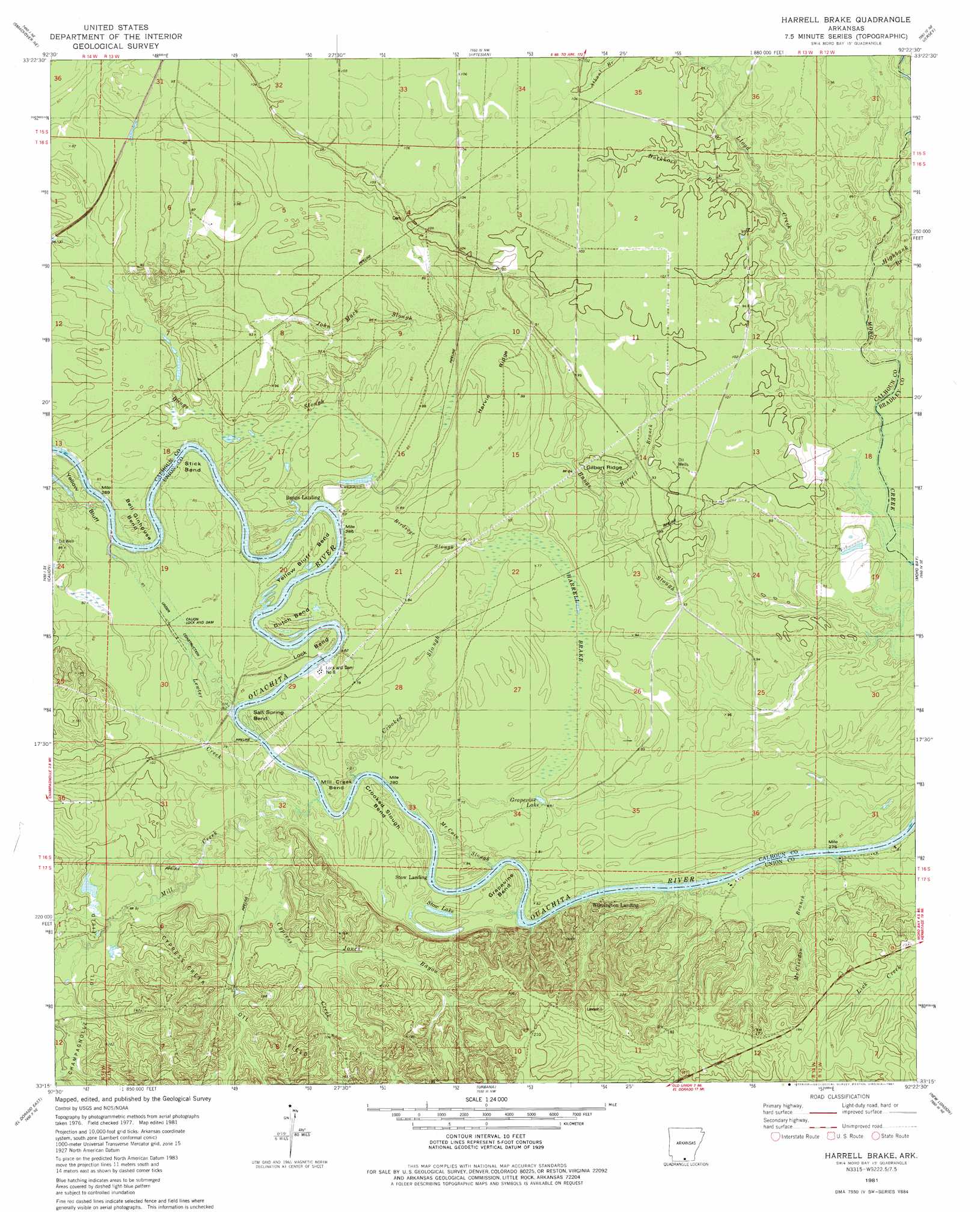
USGS Topo Quad 33092c4 - 1:24,000 scale
| Topo Map Name: | Harrell Brake |
| USGS Topo Quad ID: | 33092c4 |
| Print Size: | ca. 21 1/4" wide x 27" high |
| Southeast Coordinates: | 33.25° N latitude / 92.375° W longitude |
| Map Center Coordinates: | 33.3125° N latitude / 92.4375° W longitude |
| U.S. State: | AR |
| Filename: | o33092c4.jpg |
| Download Map JPG Image: | Harrell Brake topo map 1:24,000 scale |
| Map Type: | Topographic |
| Topo Series: | 7.5´ |
| Map Scale: | 1:24,000 |
| Source of Map Images: | United States Geological Survey (USGS) |
| Alternate Map Versions: |
Harrell Brake AR 1981, updated 1981 Download PDF Buy paper map Harrell Brake AR 2011 Download PDF Buy paper map Harrell Brake AR 2014 Download PDF Buy paper map |
1:24,000 Topo Quads surrounding Harrell Brake
East Camden |
Woodberry |
Hampton |
Banks |
Farmville |
Snow Hill |
Smackover Ne |
Artesian |
Jersey |
Hermitage |
Smackover |
Calion |
Harrell Brake |
Moro Bay |
Marsden |
El Dorado West |
El Dorado East |
Urbana |
New London |
New Union |
Junction City |
Lockhart |
Gardner |
Strong |
Huttig |
> Back to 33092a1 at 1:100,000 scale
> Back to 33092a1 at 1:250,000 scale
> Back to U.S. Topo Maps home
Harrell Brake topo map: Gazetteer
Harrell Brake: Bends
Bell Ginhouse Bend elevation 27m 88′Crooked Slough Bend elevation 22m 72′
Dutch Bend elevation 27m 88′
Grapevine Bend elevation 25m 82′
Lock Bend elevation 25m 82′
Mill Creek Bend elevation 25m 82′
Salt Spring Bend elevation 23m 75′
Stick Bend elevation 26m 85′
Yellow Bluff Bend elevation 26m 85′
Harrell Brake: Cliffs
Yellow Bluff elevation 28m 91′Harrell Brake: Crossings
Lloyd Ford elevation 25m 82′Harrell Brake: Dams
Calion Lock and Dam elevation 20m 65′Lock and Dam Number 8 elevation 22m 72′
Lock and Dam Number Eight elevation 23m 75′
Harrell Brake: Guts
Birdseye Slough elevation 27m 88′Crooked Slough elevation 25m 82′
John Mack Slough elevation 28m 91′
McCain Slough elevation 23m 75′
Harrell Brake: Lakes
Grapevine Lake elevation 23m 75′Stow Lake elevation 23m 75′
Harrell Brake: Oilfields
Cypress Creek Oil Field elevation 46m 150′Wilmington Oil and Gas Field elevation 54m 177′
Harrell Brake: Reservoirs
Ouachita River Reservoir elevation 23m 75′Harrell Brake: Ridges
Big Swamp Ridge elevation 28m 91′Gilbert Ridge elevation 30m 98′
Harvin Ridge elevation 27m 88′
Harrell Brake: Streams
Buckhorn Branch elevation 28m 91′Cypress Creek elevation 20m 65′
Harrell Branch elevation 27m 88′
Highbank Branch elevation 25m 82′
Hurricane Creek elevation 29m 95′
Jones Bayou elevation 31m 101′
Lewter Creek elevation 22m 72′
Lloyd Creek elevation 25m 82′
McClendon Branch elevation 25m 82′
Mill Creek elevation 22m 72′
Wolf Branch elevation 25m 82′
Harrell Brake: Swamps
Harrell Brake elevation 24m 78′Harrell Brake digital topo map on disk
Buy this Harrell Brake topo map showing relief, roads, GPS coordinates and other geographical features, as a high-resolution digital map file on DVD: